
September 30, 2024 (11:00 PM) – Typhoon Julian (#JulianPH) continues to strengthen as it moves westward over the Luzon Strait, maintaining maximum sustained winds of 175 km/h near the center, gusts of up to 215 km/h, and a central pressure of 935 hPa.
The center of the typhoon is currently located 155 km west-southwest of Itbayat, Batanes.
The typhoon is expected to bring strong winds and heavy rainfall to northern Luzon, prompting the Philippine Atmospheric, Geophysical and Astronomical Services Administration (PAGASA) to raise Tropical Cyclone Wind Signals (TCWS) in several areas.
Wind Signals in Effect:

- TCWS No. 3: Gale-force winds (89-117 km/h) expected in Batanes and northeastern Babuyan Islands. Moderate to significant damage to life and property is possible.
- TCWS No. 2: Gale-force winds (62-88 km/h) in the Babuyan Islands, Ilocos Norte, northern Apayao, and northwestern mainland Cagayan. Minor to moderate damage is anticipated.
- TCWS No. 1: Strong winds (39-61 km/h) in Ilocos Sur, La Union, Pangasinan, and parts of the Cordillera and Cagayan regions. Minimal to minor impacts expected.
Severe Weather Hazards:
- Heavy Rainfall: Typhoon Julian may cause flash floods and landslides, especially in mountainous areas and along rivers.
- Coastal Inundation: Life-threatening storm surges are forecast for low-lying areas in Batanes and Babuyan Islands within the next 48 hours.
- Sea Conditions: Gale warnings are in effect, with rough to high seas reaching up to 9 meters in Batanes and up to 8 meters in Babuyan Islands. All sea travel is advised to cease as conditions are extremely dangerous.
Forecast Track:
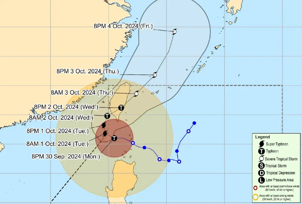
Typhoon Julian is expected to turn west-northwest tomorrow, potentially leaving the Philippine Area of Responsibility (PAR) by the morning of October 1.
It is projected to make landfall along Taiwan’s southwestern coast on October 2 before moving towards the East China Sea and exiting PAR on October 3.
The storm is expected to intensify into a super typhoon within 24 hours before weakening slightly due to its interaction with Taiwan’s mountainous terrain.
Authorities are advising residents in affected areas to stay alert, follow local evacuation protocols, and prepare for potentially dangerous conditions.
For more information on rainfall warnings and local weather advisories, monitor updates from PAGASA.