Super Typhoon Leon (Kong-rey) has moved closer to Batanes, bringing powerful winds and the risk of severe coastal flooding to Northern Luzon.
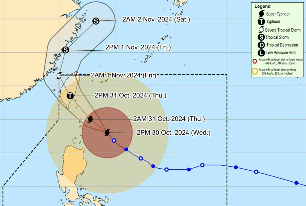
According to PAGASA’s 5:00 PM bulletin, Leon’s eye is now just 215 km east-southeast of Basco, Batanes, sustaining maximum winds of 185 km/h, with gusts reaching up to 230 km/h.
Path and Areas of Concern
Leon is advancing northwest at 20 km/h, and its extensive storm field means that typhoon-force winds can be felt up to 600 km from its center.
This places Batanes and Babuyan Islands under significant risk, with the storm expected to reach its peak intensity as it approaches late tonight or early tomorrow.
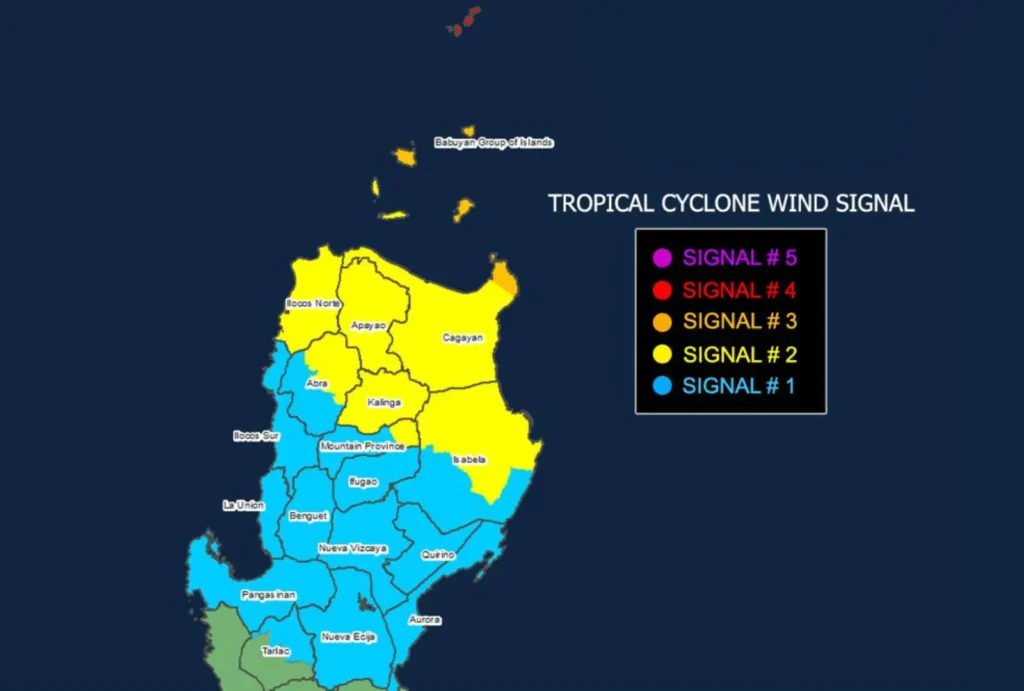
Tropical Cyclone Wind Signals in Effect

- Signal No. 4 is now raised in Batanes, indicating typhoon-force winds with speeds of 118-184 km/h and a severe threat to life and property.
- Signal No. 3 covers the eastern portion of Babuyan Islands and northeastern mainland Cagayan, where residents should prepare for strong winds that can cause moderate to significant damage.
- Signal No. 2 extends to other parts of Babuyan Islands, mainland Cagayan, and parts of Isabela, Apayao, Kalinga, Abra, and Ilocos Norte. These areas can expect gale-force winds, with possible minor to moderate impacts.
- Signal No. 1 is in effect for other parts of Northern Luzon, including the rest of Isabela, Quirino, Nueva Vizcaya, and parts of Mountain Province, Ifugao, and Benguet, with minimal to minor impacts expected.
Additional Hazards
The risk of life-threatening storm surges of over 3.0 meters is high along exposed coastlines of Batanes and Babuyan Islands, especially low-lying areas, within the next 48 hours.
Residents are advised to monitor for storm surge warnings and take immediate action as needed.
PAGASA has also issued Gale Warnings, with sea conditions forecasted to reach up to 14 meters along the Batanes seaboard.
Conditions along the eastern seaboards of Central and Southern Luzon are similarly dangerous, with waves up to 10 meters high expected.
All maritime travel is suspended across affected areas, and vessels are advised to remain in port until the typhoon passes.
Track and Outlook

Leon is forecast to make landfall along Taiwan’s eastern coast tomorrow afternoon.
After crossing Taiwan, it is expected to turn north-northwestward towards the East China Sea, with possible exit from the Philippine Area of Responsibility (PAR) by Thursday evening or early Friday morning.
While a direct landfall in Batanes is still possible, any close approach will bring intense conditions to the area.
Public Advisory
PAGASA advises residents in affected areas to prepare for worsening conditions, particularly in Batanes, where significant impacts from typhoon-force winds and coastal flooding are anticipated.
Communities should heed local evacuation orders and continue monitoring weather advisories.
