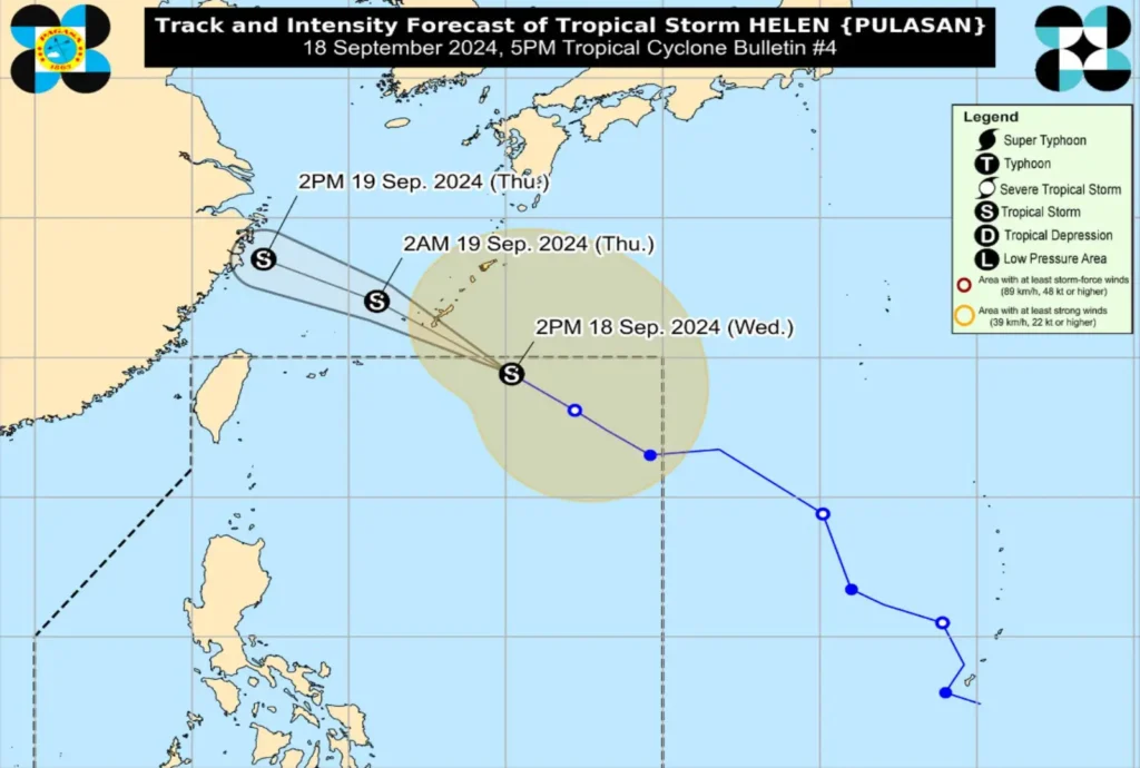
Issued at: 5:00 PM, 18 September 2024
Tropical Storm “Helen” (PULASAN) is about to exit the Philippine Area of Responsibility (PAR) as it continues to move northwestward at 40 km/h. The storm, currently located 930 km east northeast of Extreme Northern Luzon, has maximum sustained winds of 85 km/h and gustiness up to 105 km/h.
While Helen poses no direct threat to any part of the country, the Southwest Monsoon, enhanced by both Tropical Storm Helen and Tropical Storm Gener, is bringing strong to gale-force winds to several areas, especially along coastal and upland regions.
Areas Affected by Strong Winds Today:
- Zambales, Bataan, Pampanga, Bulacan, Metro Manila
- CALABARZON, MIMAROPA, Bicol Region, Visayas
- Zamboanga Peninsula, Northern Mindanao, Caraga, and Davao Region
Areas Affected by Strong Winds Tomorrow (19 September):
- Ilocos Region, Isabela, Aurora, Zambales, Bataan
- Metro Manila, CALABARZON, MIMAROPA, Bicol Region, Western Visayas
- Negros Island Region, Zamboanga Peninsula
Coastal Hazards
A Gale Warning is in effect over the western seaboards of Central Luzon, Occidental Mindoro, and Palawan, including Kalayaan Islands. Sea travel remains dangerous, especially for small vessels, due to rough sea conditions, with waves reaching 1.5 to 3.5 meters in certain areas.
Track and Intensity Forecast

Tropical Storm Helen is expected to exit PAR within the next three hours and will gradually weaken as it moves over the East China Sea. Despite no direct land impact, the public is advised to stay updated on the heavy rainfall and severe wind advisories due to the Southwest Monsoon.
Safety Advisory
Residents in areas susceptible to flooding or landslides should take necessary precautions and follow any evacuation instructions from local authorities. Stay tuned to PAGASA for more localized severe weather updates.
