
Super Typhoon Julian (KRATHON) has intensified slightly as it moves westward, now positioned 235 km west of Itbayat, Batanes, according to the Philippine Atmospheric, Geophysical, and Astronomical Services Administration (PAGASA).
The storm exited the Philippine Area of Responsibility (PAR) earlier today, but it could re-enter tomorrow as it tracks towards Taiwan.
Current Status and Location
As of 10:00 AM today, the eye of Super Typhoon Julian was located at 20.7°N, 119.6°E. It has maximum sustained winds of 195 km/h near the center, gusts up to 240 km/h, and a central pressure of 915 hPa.
The typhoon is moving slowly westward, with its wind field extending up to 630 km from the center, generating strong to typhoon-force winds.
Tropical Cyclone Wind Signals in Effect
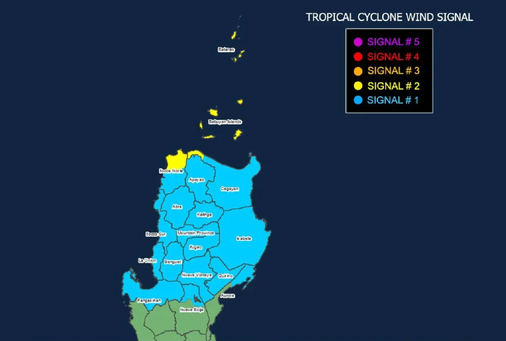
- Tropical Cyclone Wind Signal (TCWS) No. 2 remains in effect for Batanes, Babuyan Islands, northern Ilocos Norte, and the northwestern portion of mainland Cagayan. These areas are expected to experience gale-force winds (62 to 88 km/h) within the next 24 hours, posing a minor to moderate threat to life and property.
- TCWS No. 1 is hoisted over the rest of Ilocos Norte, Ilocos Sur, La Union, Pangasinan, Apayao, Kalinga, Abra, Mountain Province, Ifugao, Benguet, and parts of Cagayan, Isabela, Quirino, Nueva Vizcaya, Aurora, and Nueva Ecija. Strong winds (39 to 61 km/h) are expected in these areas, with minimal to minor impacts on life and property.
Rainfall and Wind Impacts
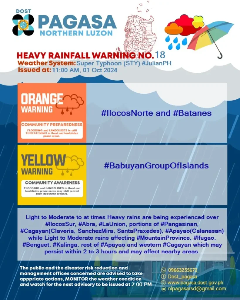
Though Julian is currently outside the PAR, its circulation will continue to enhance local weather conditions in Northern Luzon.
Areas under TCWS are expected to experience strong winds, particularly coastal and upland regions exposed to the typhoon’s gusts. Gale-force gusts are also likely in Ilocos Region, Cordillera Administrative Region, and parts of Cagayan and Isabela.
Coastal Hazards and Sea Conditions
- Gale warnings remain in effect for the northern and western seaboards of Northern Luzon. Seas in Batanes could reach up to 7 meters in height, while the Babuyan Islands and Ilocos Norte may see waves up to 6 meters. Smaller sea vessels and motorbancas are advised to stay in port due to these dangerous sea conditions.
- There is also a moderate to high risk of storm surge in low-lying coastal areas of Batanes and Babuyan Islands over the next 48 hours, with potentially life-threatening flooding in these areas.
Typhoon Track and Outlook
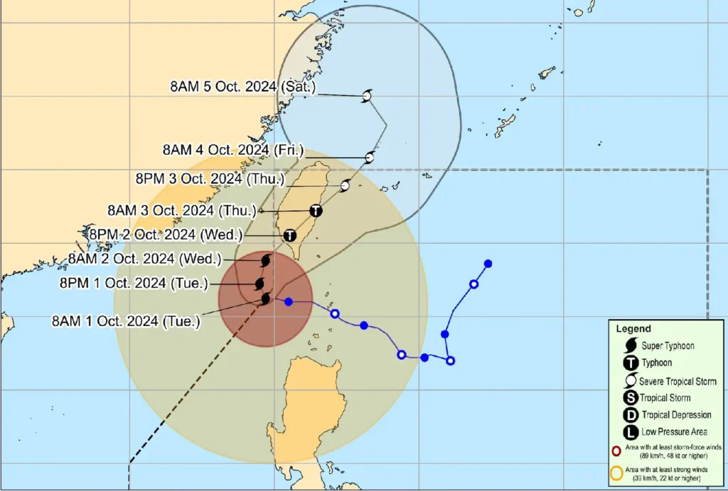
Julian is forecast to move towards Taiwan, with landfall expected along its southwestern coast by tomorrow morning or afternoon. It will then traverse Taiwan’s mountainous terrain, which may weaken it to a severe tropical storm by Thursday. PAGASA also noted the possibility of Julian re-entering the PAR tomorrow before it moves towards the East China Sea by Friday morning.
Preparedness Measures
PAGASA urges the public, particularly those in affected areas, to continue monitoring weather updates and follow instructions from local disaster risk reduction and management offices. Residents in areas prone to landslides, flooding, and storm surges should remain vigilant and be ready for possible evacuation.
For more localized weather updates, including heavy rainfall advisories and storm surge warnings, refer to PAGASA’s Weather Advisory No. 23 and Storm Surge Warning No. 8.