
Severe Tropical Storm Pepito (Man-Yi) has weakened and is now over the West Philippine Sea, according to the latest Tropical Cyclone Bulletin issued at 11:00 AM today.
As of 10:00 AM, the center of Pepito was located 270 km west of Batac, Ilocos Norte, with maximum sustained winds of 110 km/h near the center and gustiness of up to 135 km/h.
The storm is moving west northwestward at a speed of 20 km/h.
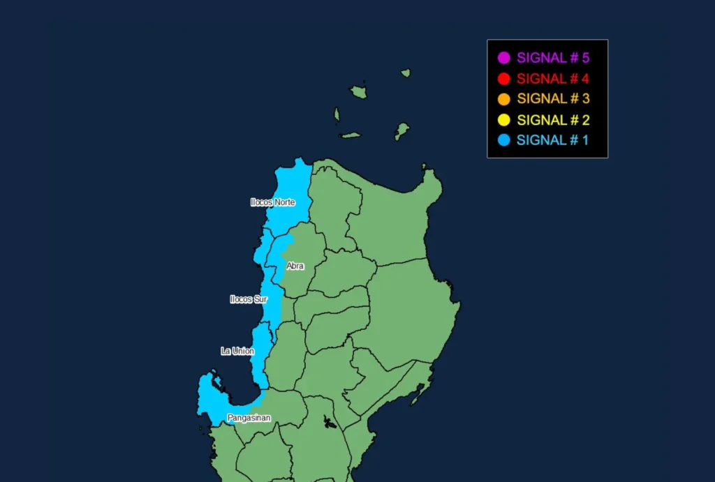
Currently, Tropical Cyclone Wind Signal No. 1 is raised over Ilocos Norte, Ilocos Sur, La Union, the western portion of Pangasinan (including Burgos, Dasol, Sual, Mabini, Binmaley, San Fabian, Dagupan City, Lingayen, Labrador, City of Alaminos, Bolinao, Anda, Bani, Agno, Infanta, Bugallon, and Mangaldan), and the western portion of Abra (covering Danglas, Bangued, Langiden, La Paz, Pidigan, San Quintin, San Isidro, Pilar, Peñarrubia, Villaviciosa, and Lagayan).
Areas under this signal may experience strong winds ranging from 39 to 61 km/h within 36 hours, posing minimal to minor threats to life and property.
Sea Conditions and Warnings:
The threat of storm surge has diminished as Pepito continues to move away from the Philippines.
However, a Gale Warning remains in effect for the northern seaboard of Northern Luzon. Up to very rough seas, with waves reaching up to 4.5 meters, are expected along the seaboard of Batanes.
Additionally, rough sea conditions are anticipated over the seaboards of Ilocos Norte and the western seaboard of the Babuyan Islands, with wave heights of up to 4.0 meters.
Mariners of small seacrafts are strongly advised to avoid sea travel under these conditions.
Moderate sea conditions, with waves up to 2.5 meters, are also expected over other seaboards, including the remaining areas of Cagayan Valley, northern Aurora, northern Zambales, and the Kalayaan Islands.
Precautionary measures are advised for all mariners in these areas.
Track and Intensity Outlook:
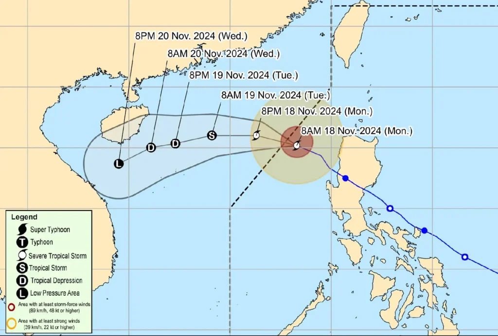
Pepito is forecast to continue its west northwestward trajectory today and exit the Philippine Area of Responsibility (PAR) by noon or afternoon.
Upon leaving PAR, it is expected to turn westward or west southwestward on Tuesday, influenced by an incoming northeasterly wind surge.
Further weakening is anticipated, with Pepito potentially becoming a remnant low by Wednesday, November 20.
Communities and local disaster response units are urged to take the necessary precautions to ensure safety and protect property.
Residents in hazard-prone areas should remain alert for instructions from local authorities and monitor updates from PAGASA for severe weather advisories.