


15 November 2024, 5:00 AM — Severe Tropical Storm Pepito (MAN-YI) continues to strengthen, drawing closer to reaching typhoon status as it tracks westward at 25 km/h across the Philippine Sea.
As of 4:00 AM, Pepito was located 795 kilometers east of Guiuan, Eastern Samar, with maximum sustained winds of 110 km/h near the center, gusts up to 135 km/h, and a central pressure of 980 hPa.
Areas Under Tropical Cyclone Wind Signal No. 1
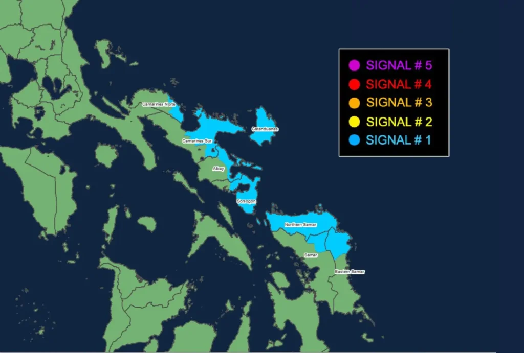
The eastern provinces of Luzon and portions of the Visayas are under Signal No. 1, which indicates a 36-hour warning lead time for strong winds ranging from 39 to 61 km/h. The affected areas include:
- Luzon: Catanduanes, eastern Camarines Norte, eastern Camarines Sur, eastern Albay, and parts of Sorsogon
- Visayas: Northern Samar, northern Eastern Samar, and northeastern Samar
Residents in these areas should prepare for potential minimal to minor impacts on life and property, with particular caution in exposed and mountainous locations.
Heavy Rainfall and Wind Hazards
Though Pepito is not yet directly affecting the country, a heavy rainfall advisory has been issued, anticipating the storm’s impacts. Strong winds may be locally intensified along coastal and elevated areas.
The possibility of life-threatening storm surges, reaching 2.0 to 3.0 meters, threatens low-lying communities in Camarines Sur, Catanduanes, Albay, Sorsogon, and parts of Samar and Northern Samar.
Coastal Waters and Sea Conditions
Mariners are advised of hazardous sea conditions, with wave heights up to 5.0 meters in Batanes and the Babuyan Islands’ seaboards, and up to 4.5 meters in Ilocos Norte and Cagayan.
Sea travel is deemed highly risky for all vessels in these areas. Rough seas are also expected along the eastern coastlines of Northern Samar, Eastern Samar, and down to Dinagat Islands.
Track and Intensity Forecast
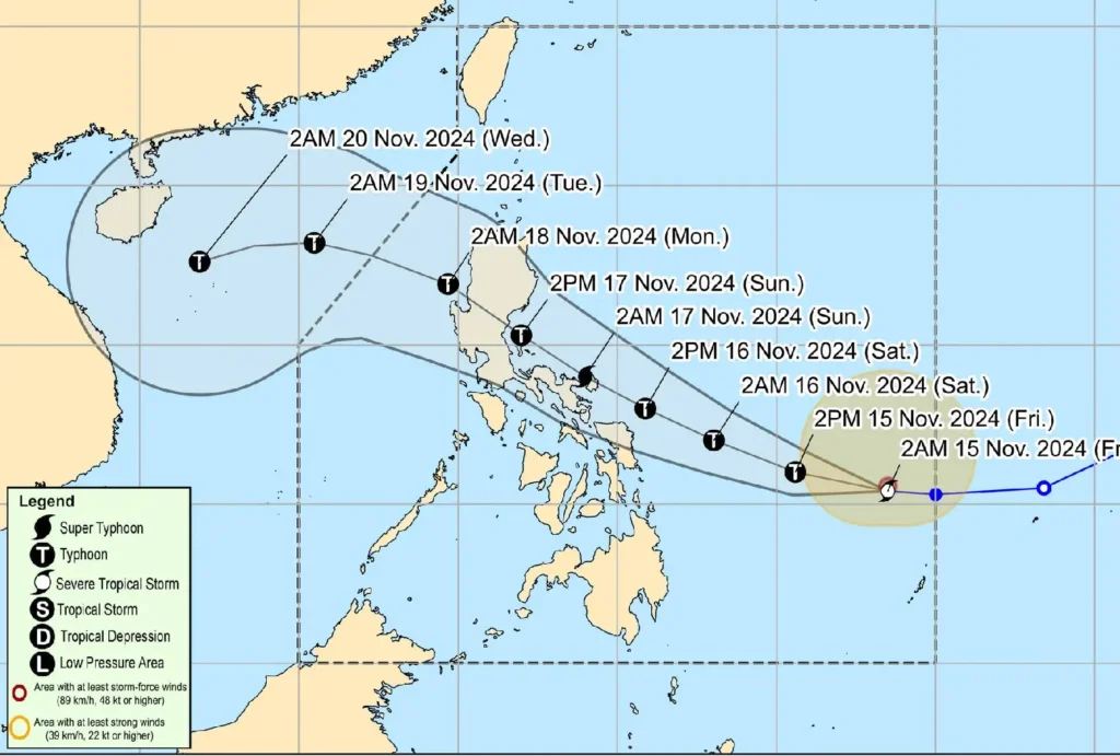
Pepito is projected to intensify into a typhoon within 12 hours and may escalate into a super typhoon by Saturday evening, possibly reaching peak strength before making landfall.
The cyclone is expected to impact Central and Southern Luzon with violent conditions over the weekend, bringing widespread disruptions and heavy rains until Sunday.
A weakening trend is anticipated as it crosses mainland Luzon, likely exiting the Philippine Area of Responsibility by Monday evening.
Advisory
Communities in the projected path and adjacent areas should continue to monitor updates and heed advisories from local authorities, especially concerning storm surge risks and travel restrictions. Mariners, in particular, must remain vigilant and avoid venturing out to sea.