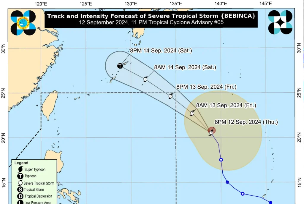
Severe Tropical Storm BEBINCA slightly weakened as it began turning north-northwestward, according to the latest weather bulletin issued by PAGASA. At 10:00 PM, the center of BEBINCA was located approximately 1,725 km east of Extreme Northern Luzon, based on all available data.
The storm’s maximum sustained winds were recorded at 95 km/h near its center, with gusts reaching up to 115 km/h and a central pressure of 990 hPa.
The storm is currently moving north-northwestward at a speed of 25 km/h. Strong winds extending up to 580 km from the center are being experienced.

In the next 24 hours, moderate to rough seas, ranging from 1.0 to 3.5 meters in height, are expected along the eastern seaboard of Mindanao, Palawan, and the western seaboard of Visayas. Northern Luzon and the southern seaboard of Mindanao will also experience rough sea conditions.
Mariners operating small seacrafts, particularly motorbancas, are strongly advised against sea travel during this period due to hazardous conditions.
Additionally, BEBINCA is expected to shift northwestward tomorrow, and by Saturday, it will continue on a west-northwestward path.
BEBINCA is forecast to enter the Philippine Area of Responsibility (PAR) by tomorrow afternoon or evening, and exit PAR late tomorrow evening or early Saturday morning.
Although the storm is projected to remain distant from the Philippine landmass, it is likely to intensify into a typhoon by Saturday.
The public is urged to stay updated on developments related to BEBINCA, and disaster risk reduction and management offices are advised to maintain preparedness.
The next tropical cyclone advisory is scheduled for 11:00 AM tomorrow, unless an intermediate bulletin is issued.
