Severe Tropical Storm “Bebinca” Maintains Strength as It Approaches Philippine Area of Responsibility (PAR)
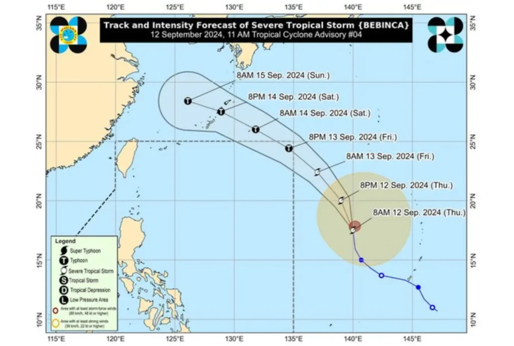
The Severe Tropical Storm “Bebinca” continues to move northward over the Philippine Sea, maintaining its strength as it approaches the Philippine Area of Responsibility (PAR).
As of 10:00 AM today, the center of “Bebinca” was located 1,975 km east of Central Luzon and 1,930 km east of Northern Luzon, with maximum sustained winds of 95 km/h and gusts reaching up to 115 km/h.
The storm is moving west-northwestward at 25 km/h.

Strong to storm-force winds extend up to 580 km from the center, prompting warnings for rough seas in the coming days.
Mariners and operators of small seacrafts and motorbancas are advised to avoid sea travel due to potentially hazardous conditions.
The enhanced Southwest Monsoon is expected to bring moderate to rough seas, particularly along the eastern seaboard of Mindanao (waves between 1.0 to 3.5 meters) and the western seaboards of Palawan, Visayas, and Mindanao.
Up to moderate seas (waves up to 2.0 meters) are forecast over the southern seaboard of Mindanao, with mariners advised to take precautionary measures. Small vessels are particularly cautioned against venturing out during these conditions.
The forecast indicates that “Bebinca” will enter the PAR by tomorrow evening and intensify into a typhoon by Friday night.
However, the storm is expected to remain far from the Philippine landmass and is predicted to exit the PAR by late tomorrow or early Saturday morning.
The public and disaster management offices are urged to stay updated on the latest advisories from the authorities. The next tropical cyclone advisory will be issued at 11:00 PM today.
