
16 November 2024, 11:00 AM – Super Typhoon Pepito (international name: MAN-YI) continues to intensify as it approaches the Bicol Region, carrying maximum sustained winds of 185 km/h and gusts of up to 230 km/h.
The Philippine Atmospheric, Geophysical and Astronomical Services Administration (PAGASA) reports that the typhoon’s eye was located 185 km east of Catarman, Northern Samar, or 250 km east of Juban, Sorsogon, moving west-northwest at 25 km/h.
Areas Under Tropical Cyclone Wind Signals:
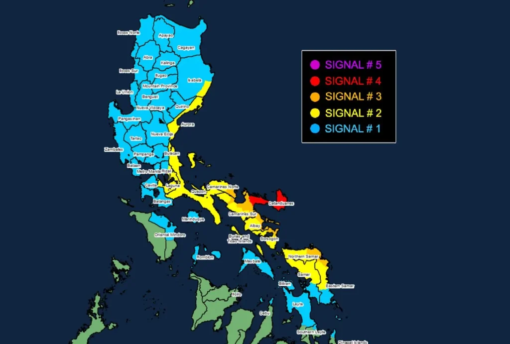
- Signal No. 4: Catanduanes and northeastern Camarines Sur will experience typhoon-force winds with speeds between 118 to 184 km/h, posing a severe threat to life and property. Residents must take immediate precautions as impacts will be significant.
- Signal No. 3: Parts of Camarines Norte, Albay, and Northern Samar are under storm-force winds, with speeds up to 117 km/h. Moderate to significant damage is expected.
- Signal No. 2: Gale-force winds are forecast for areas in Isabela, Aurora, Quezon, and Laguna, among others. These areas will face minor to moderate damage.
- Signal No. 1: Strong winds of 39 to 61 km/h will affect Metro Manila, Ilocos Region, and other parts of Luzon, with minimal to minor threats anticipated.
Coastal Hazards
PAGASA warns of life-threatening storm surges exceeding 3 meters along the coastlines of Ilocos Region, Isabela, Metro Manila, CALABARZON, Bicol, Northern Samar, and Leyte.
Mariners should avoid sea travel, with very rough seas up to 14 meters expected in Catanduanes and surrounding waters.
Rainfall and Severe Wind Outlook
Heavy rain is expected, which may lead to flooding and landslides. The public is urged to refer to PAGASA’s Weather Advisory No. 43 for the three-day rainfall outlook. Severe winds may also affect areas outside the landfall point, and caution is advised.
Typhoon Track and Intensity
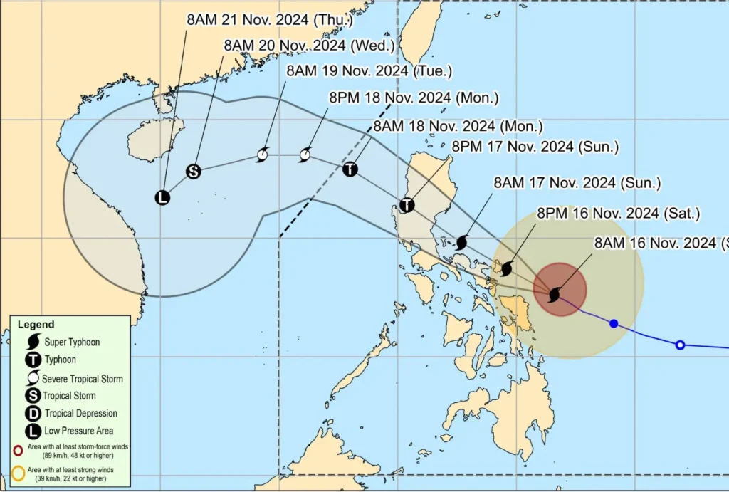
Pepito is forecast to make landfall in Catanduanes late tonight or early tomorrow, with a possible impact in Camarines Sur or Albay.
The system will then move across Bicol, Quezon, Aurora, Nueva Ecija, and Pangasinan before emerging over the West Philippine Sea by Monday.
The typhoon may further strengthen if its eyewall replacement cycle completes before landfall.
Residents are strongly advised to remain vigilant, follow local authorities’ instructions, and prepare for possible evacuations in high-risk areas.