
- Advertisement -
Super Typhoon Ofel (Usagi) remains an extreme threat as it heads toward the Cagayan Valley Region, packing maximum sustained winds of 185 km/h near the center and gusts reaching up to 230 km/h.
The cyclone is currently moving west-northwest at 15 km/h, with its eye located over the coastal waters of Divilacan, Isabela as of 10:00 AM.
- Advertisement -
Tropical Cyclone Wind Signals in Effect
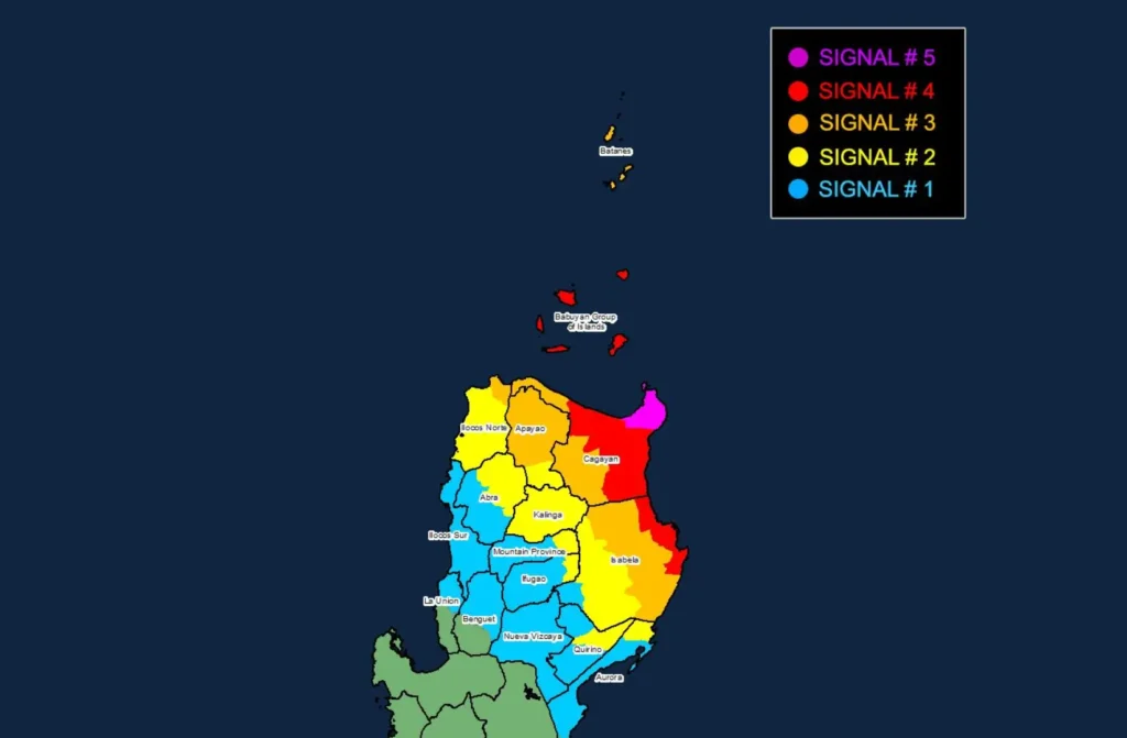
- Signal No. 5: Northeastern mainland Cagayan (Santa Ana, Gonzaga) facing typhoon-force winds within 12 hours. Extreme damage to life and property is anticipated.
- Signal No. 4: Babuyan Islands and parts of mainland Cagayan and northeastern Isabela (e.g., Palanan, Baggao) could experience significant damage from intense winds.
- Signal No. 3: Storm-force winds threaten Batanes, northern Apayao, and parts of Ilocos Norte, with moderate to severe impact risks.
- Signal No. 2: Gale-force winds will affect Kalinga, Ifugao, and parts of Mountain Province and Ilocos Norte, bringing a moderate threat to life and property.
- Signal No. 1: Strong winds expected in Nueva Vizcaya, the rest of Quirino, and northern La Union, posing minimal to minor risks.
Hazards and Safety Precautions
- Heavy Rainfall: Extreme rainfall warnings are in effect; refer to Weather Advisory No. 30.
- Severe Winds: Areas under higher wind signals should prepare for destructive wind impacts, with enhanced local winds possible in elevated or coastal zones.
- Storm Surge Warning: Coastal areas from Batanes to northern Aurora may face life-threatening storm surges up to 3.0 meters. Residents are advised to evacuate if necessary.
- Sea Conditions:
- Very rough seas (up to 12 meters) near Cagayan’s seaboard, extremely hazardous for all vessels.
- Risky sea travel conditions are expected across Isabela and Batanes coasts, with waves reaching up to 8 meters.
- Mariners and small boat operators are urged to remain in port or seek shelter until conditions improve.
Track and Intensity Forecast
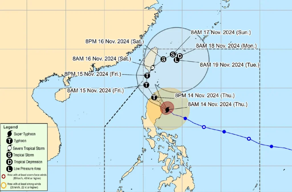
Super Typhoon Ofel is set to make landfall this afternoon along Cagayan’s eastern coast.
It will traverse the Babuyan Channel and may affect Babuyan Islands before moving northward over the waters west of Batanes by Friday, then turning northeast over the sea east of Taiwan by Saturday. Despite gradual weakening, the typhoon is expected to remain dangerously strong upon landfall.
- Advertisement -