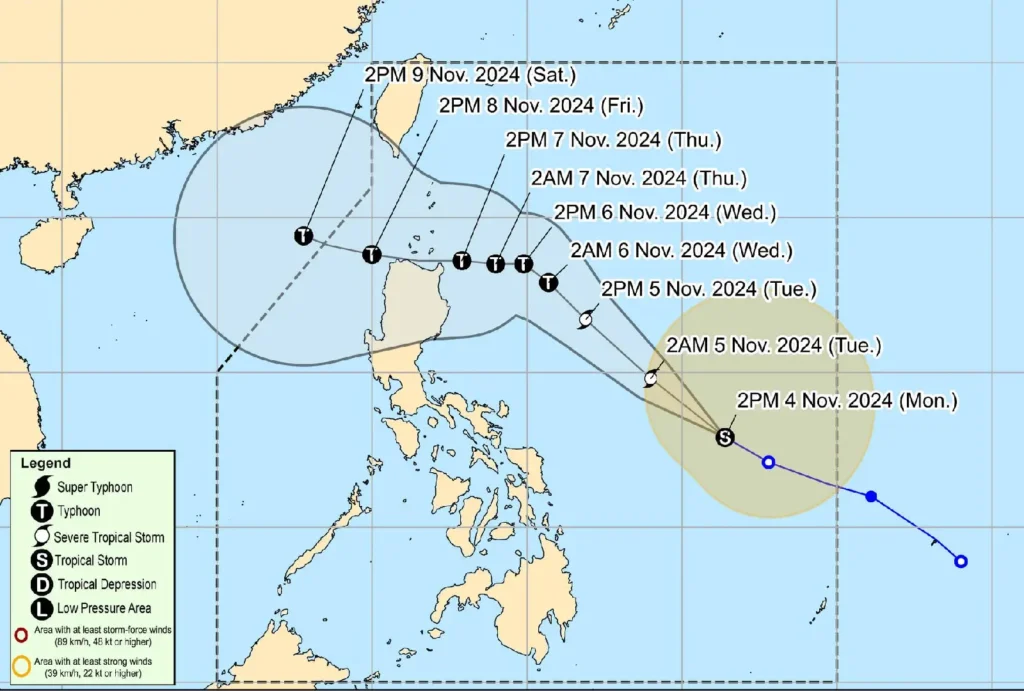
Tropical Storm Marce (Yinxing) has intensified over the Philippine Sea, now situated approximately 740 km east of Virac, Catanduanes.
With maximum sustained winds of 85 km/h near its center and gusts reaching 105 km/h, Marce is moving west-northwestward at 30 km/h, according to PAGASA’s latest bulletin.
Wind Signals and Potential Landfall

While no tropical cyclone wind signals are currently in effect, PAGASA forecasts that Wind Signal No. 1 may be raised over parts of Cagayan tonight or tomorrow.
Marce could intensify to a typhoon by Wednesday and make landfall near the Babuyan Islands or mainland northern Cagayan on Thursday evening or Friday morning.
There is also a potential for further changes to the track, possibly shifting landfall towards mainland Cagayan or Isabela.
Rainfall and Wind Outlook
Marce’s circulation is expected to enhance the northeasterly wind flow, bringing heavy rains to Extreme Northern Luzon and the eastern part of Luzon beginning tomorrow.
Residents are advised to monitor PAGASA updates as the tropical storm moves closer to the region, with rainfall expected to increase progressively.
Additionally, strong to gale-force winds are forecast over parts of Northern Luzon:
- November 4: Batanes, Cagayan (including Babuyan Islands), Isabela, Ilocos Norte, Aurora, and northern Quezon.
- November 5: Batanes, Cagayan, Isabela, Ilocos Norte, Ilocos Sur, Aurora, Quezon, and Camarines Norte.
- November 6: Ilocos Region, Quezon, Camarines Norte, Camarines Sur, and Catanduanes.
Coastal Conditions and Gale Warnings
Rough seas, reaching up to 3.5 meters, are expected along the seaboards of Batanes, Babuyan Islands, Ilocos Norte, and other areas along northern Luzon.
Mariners, especially those with small boats, are advised against sea travel due to dangerous conditions. Gale warnings are anticipated for Northern Luzon’s seaboard by tomorrow.
Public Advisory
With Marce forecasted to intensify further, local authorities and residents in potentially affected areas are advised to prepare for worsening weather.
PAGASA and local disaster management offices recommend vigilance for possible evacuations and adherence to safety advisories.
Further updates on heavy rainfall and wind advisories will be issued as Marce advances toward Northern Luzon.
