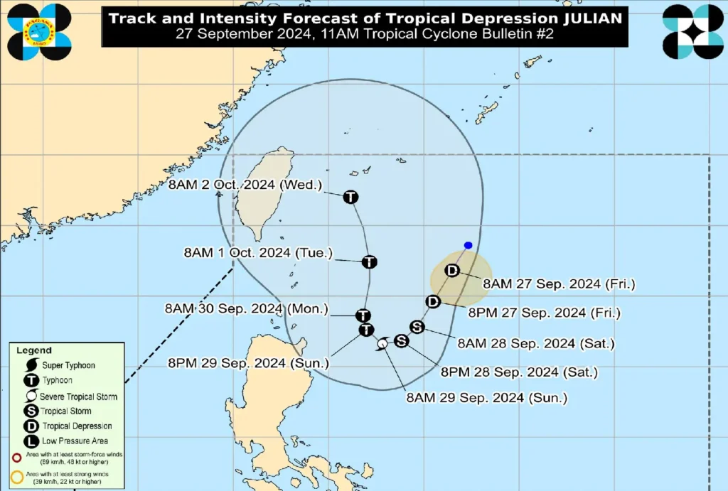
The Philippine Atmospheric, Geophysical, and Astronomical Services Administration (PAGASA) has issued its second tropical cyclone bulletin for Tropical Depression Julian, which remains almost stationary over the Philippine Sea, east of Batanes.
As of 10:00 AM today, the center of the tropical depression was located 525 km east of Itbayat, Batanes (20.9°N, 126.9°E).
Storm Intensity and Movement
Tropical Depression Julian is currently packing maximum sustained winds of 55 km/h near the center, with gustiness reaching up to 70 km/h.
The system’s central pressure is at 1004 hPa, and it remains almost stationary over the region.
Strong winds extend outward up to 150 km from the storm’s center, making conditions hazardous over a broad area.
Possible Tropical Cyclone Wind Signals
Tropical Cyclone Wind Signal No. 1 may be raised over parts of the Cagayan Valley region within the day, with the potential for Wind Signal No. 2 or 3 in the coming days, depending on Julian’s intensification.
The wind circulation of the tropical depression may bring strong to gale-force gusts over areas including Aurora and northern Quezon by tomorrow, and Aurora, CALABARZON, Romblon, Marinduque, Bicol Region, Aklan, and northern Antique by Sunday.
Heavy Rainfall Outlook
PAGASA has issued Weather Advisory No. 2 for areas at risk of heavy rainfall associated with Julian.
While no specific warnings have been raised as of this report, residents are urged to stay alert for potential flooding and landslides, especially in low-lying and mountainous areas.
Coastal Waters Hazards
In addition to heavy rainfall, rough sea conditions are expected over the following areas within the next 24 hours:
- Seaboards of Batanes and Babuyan Islands and the eastern seaboard of mainland Cagayan, with waves reaching up to 3.0 meters.
- Mariners of small vessels and motorbancas are advised not to venture out to sea, especially in these areas where conditions may be hazardous.
Moderate sea conditions with waves up to 2.5 meters are expected over the remaining seaboard of Cagayan and the seaboard of Isabela.
Mariners are advised to take extra precautions while navigating these waters.
Track and Forecast

Julian is expected to follow a looping path over the waters east of Batanes and Cagayan for the next five days.
Initially, it will head south-southwestward or southwestward today and tomorrow, then move slowly westward to northwestward on Sunday.
By Monday, Julian is forecasted to accelerate northward. It is also expected to intensify into a tropical storm by tonight or tomorrow morning, with the potential to reach typhoon status by Sunday.
Public Advisory
Residents, particularly those in areas identified to be highly susceptible to flooding, strong winds, and landslides, are advised to take necessary precautions and heed the instructions of local authorities.
Disaster management offices are encouraged to prepare for potential evacuations.
Regular updates on rainfall advisories, severe weather warnings, and evacuation notices will be issued by PAGASA and local officials.
