November 16, 2024 – Typhoon Pepito continues to rapidly strengthen and poses a significant threat to Southern Luzon and Eastern Visayas, with potential to reach super typhoon status before making landfall.
The Philippine Atmospheric, Geophysical, and Astronomical Services Administration (PAGASA) has raised Tropical Cyclone Wind Signals (TCWS) in various regions as the storm barrels toward the Philippines.
Current Position and Intensity
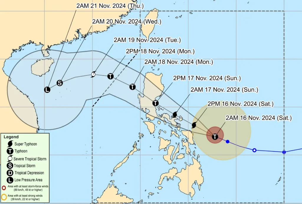
As of 4:00 AM today, Typhoon Pepito was located 220 km east northeast of Borongan City, Eastern Samar, or 305 km east of Catarman, Northern Samar.
It is moving west northwest at 25 km/h, packing maximum sustained winds of 175 km/h near the center and gusts of up to 215 km/h.
The storm’s central pressure has dropped to 940 hPa, and typhoon-force winds extend up to 440 km from the center.
Tropical Cyclone Wind Signals in Effect

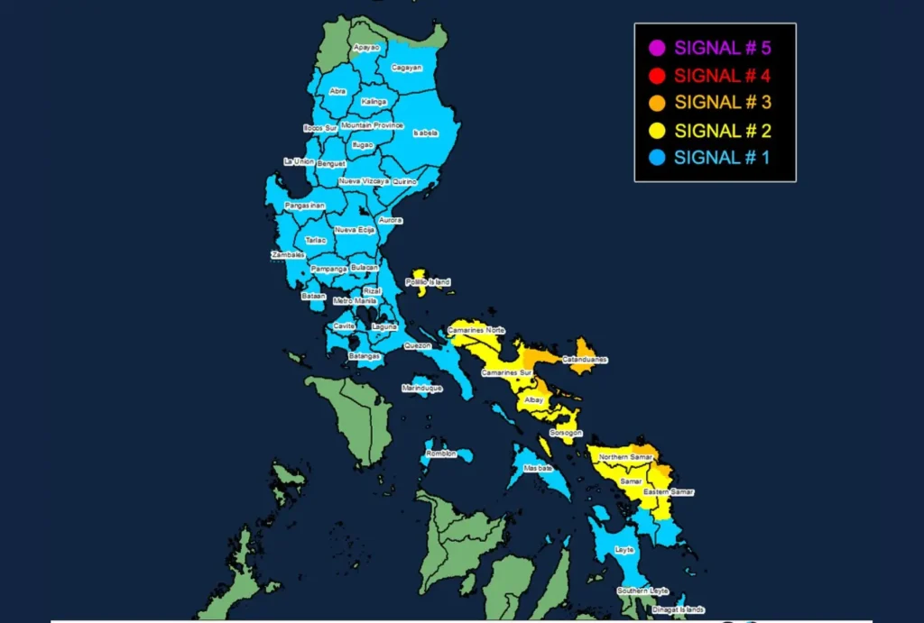
- TCWS No. 3 (Storm-Force Winds)
- Luzon: Catanduanes, eastern Albay (Rapu-Rapu, Bacacay, Tabaco City, Malilipot, Tiwi, Malinao), eastern Camarines Sur (Caramoan, Presentacion, San Jose, Garchitorena, Lagonoy, Sagñay, Tigaon, Goa), easternmost Sorsogon (Prieto Diaz)
- Visayas: Eastern Northern Samar (Palapag, Laoang, Mapanas, Gamay, Lapinig, Catubig, Pambujan), northernmost Eastern Samar (San Policarpo, Arteche, Oras, Jipapad)
- TCWS No. 2 (Gale-Force Winds)
- Luzon: Rest of Camarines Sur, rest of Albay, rest of Sorsogon, Ticao Island, Camarines Norte, easternmost mainland Quezon (Tagkawayan), Pollilo Islands
- Visayas: Northern Eastern Samar (Dolores, Maslog, Can-Avid, Taft, Sulat, San Julian, Borongan City), Northern Samar, and rest of Samar provinces
- TCWS No. 1 (Strong Winds)
- Luzon: Masbate (including Burias Island), Marinduque, Romblon, rest of Quezon, Laguna, Rizal, Cavite, Batangas, Metro Manila, Zambales, Bataan, Bulacan, Pampanga, Tarlac, Nueva Ecija, Aurora, Quirino, Nueva Vizcaya, Isabela, parts of Cagayan, Pangasinan, La Union, Ilocos Sur, Abra, southern Apayao, Kalinga, Mountain Province, Ifugao, Benguet
- Visayas: Remaining areas of Samar, Eastern Samar, Biliran, parts of Leyte and Cebu, northern Iloilo
- Mindanao: Northern Dinagat Islands
Coastal and Maritime Hazards
A Gale Warning is in effect for the eastern and southern seaboards of Southern Luzon and the eastern seaboard of Visayas. Seas will be extremely dangerous, with wave heights of:
- Up to 14.0 m along Catanduanes
- Up to 12.0 m along northern Camarines Sur
- Up to 9.0 m along Northern Samar and Camarines Norte
- Up to 7.0 m along Eastern Samar, Albay, and Sorsogon
Mariners are advised against sea travel in these areas. Even larger vessels may face hazardous conditions, and smaller crafts are highly discouraged from setting out.
Forecasted Track and Impact

Typhoon Pepito is expected to continue moving west northwestward, likely making landfall in Catanduanes tonight or early tomorrow morning.
However, the storm could veer slightly, impacting areas like Camarines Sur, Albay, Sorsogon, or even the eastern coast of Quezon or Aurora tomorrow afternoon or evening.
Pepito may intensify further today and is projected to reach super typhoon strength.
The storm will weaken as it crosses the Central Luzon landmass, but it is expected to remain a typhoon until it exits into the West Philippine Sea on Monday.
Heavy Rainfall and Flooding Threat
PAGASA has warned of intense to torrential rainfall over parts of Southern Luzon and Visayas.
Low-lying and mountainous areas should prepare for possible flooding and landslides. The public and disaster risk reduction offices are urged to take all necessary precautions to safeguard life and property.
