
- Advertisement -
Typhoon Ofel (Usagi) has weakened but continues to pose a serious threat after making landfall in Baggao, Cagayan at 1:30 PM.
The storm is currently moving west-northwest at 20 km/h, with maximum sustained winds of 175 km/h and gusts of up to 240 km/h. The typhoon’s eye was last spotted over Baggao’s coastal waters.
- Advertisement -
Current Tropical Cyclone Wind Signals
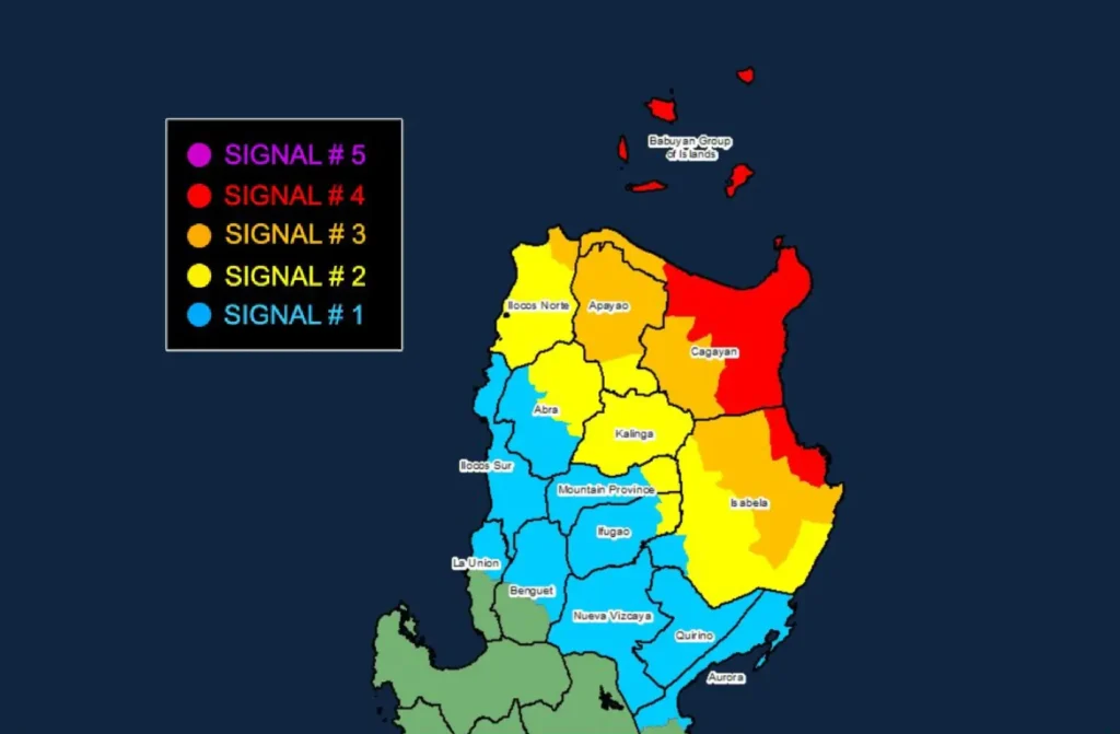
- Signal No. 4: Babuyan Islands, northern and eastern mainland Cagayan (e.g., Santa Ana, Baggao, Gonzaga), and northeastern Isabela. Expect typhoon-force winds within 12 hours with a significant threat to life and property.
- Signal No. 3: Batanes, the rest of Cagayan, parts of northern Isabela, Apayao, and Ilocos Norte are facing storm-force winds with a moderate to significant impact.
- Signal No. 2: Areas in southern Isabela, Apayao, Kalinga, parts of Abra, and Mountain Province will experience gale-force winds posing a moderate threat.
- Signal No. 1: Quirino, Nueva Vizcaya, parts of Benguet, Ilocos Sur, northern La Union, and northern Aurora face minimal to minor wind threats.
Impacts and Precautions
- Heavy Rainfall: Areas under the typhoon’s path will see intense rain. Refer to Weather Advisory No. 31 for detailed rainfall outlooks.
- Severe Winds: Typhoon-force winds are likely to cause significant damage, especially in areas under Signal No. 4.
- Storm Surge: Coastal regions from Batanes to northern Aurora face a high risk of storm surges over 3.0 meters, which can be life-threatening. Residents should follow evacuation orders.
- Sea Travel Risks: Very rough seas are expected, with waves reaching 12 meters near Cagayan and Babuyan Islands. All vessels, regardless of size, are strongly advised to stay in port.
Coastal Waters Advisory
- High Seas: The northern seaboards of Cagayan and Batanes face waves up to 12 meters, extremely hazardous for any sea travel.
- Rough Seas: Aurora and Ilocos Norte can expect waves of up to 6 meters. Small boats should not venture out.
- Moderate Seas: Waves of 2.0 to 2.5 meters may affect Camarines Norte and other regions, requiring caution for small vessels.
Track and Forecast
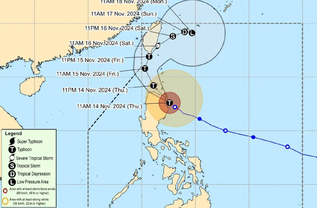
Typhoon Ofel will continue to traverse northeastern Luzon and head toward the Babuyan Islands by tonight.
It is expected to weaken further due to the interaction with Luzon’s terrain and an unfavorable environment near Taiwan.
Despite weakening, Ofel’s winds and rains remain dangerous, with the potential for further damage and flooding in affected regions.
- Advertisement -