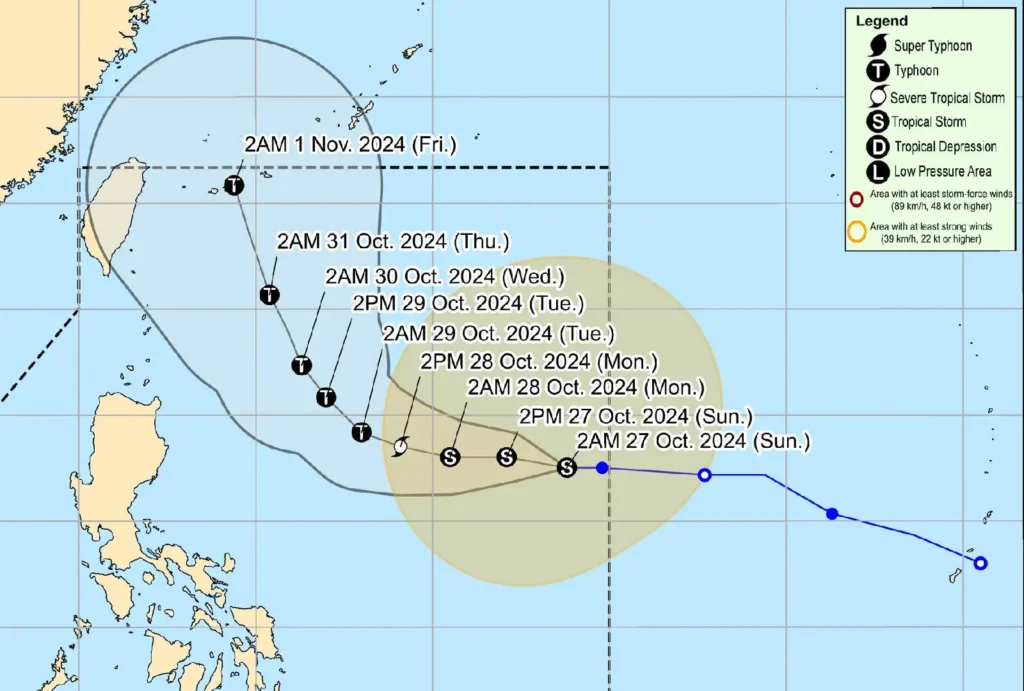
Tropical Storm Leon (Kong-Rey), currently moving westward across the Philippine Sea, remains strong but poses no immediate threat to the Philippines, according to the latest update from PAGASA.
Key Details on Tropical Storm Leon
- Location: As of 4:00 AM today, the storm’s center is approximately 1,195 km east of Central Luzon, at coordinates 16.4°N, 133.3°E.
- Intensity: Leon has sustained winds reaching 65 km/h near its center, gusts of up to 80 km/h, and a central pressure of 994 hPa.
- Movement: The storm is moving westward at 20 km/h.
- Wind Extent: Gale-force winds extend up to 640 km from the center.
No Tropical Cyclone Wind Signals Yet
Currently, there are no Tropical Cyclone Wind Signals (TCWS) raised over any parts of the Philippines. However, PAGASA noted that Wind Signal No. 1 could be hoisted over portions of Cagayan Valley and the Bicol Region by this evening, with Wind Signal No. 2 a possibility should the storm’s path shift westward.
Rainfall and Wind Outlook
Although Leon is not expected to make landfall in the Philippines, it could affect the country’s weather in the following ways:
- Outer Rainbands: Depending on the storm’s movement, rainbands may impact Extreme Northern Luzon.
- Southwesterly Windflow: Leon could enhance winds already influenced by Severe Tropical Storm Trami (formerly Kristine), bringing gusty conditions over western Southern Luzon, Visayas, and Mindanao in the coming days.
Expected areas to experience strong to gale-force gusts include:
- Today, October 27: Catanduanes, Northern Samar, Eastern Samar, and Dinagat Islands.
- Tomorrow, October 28: Northern Samar, Romblon, Masbate (including Burias and Ticao Islands), northern portions of Antique, Capiz, and parts of Negros Oriental, among others.
- Tuesday, October 29: Batangas, Oriental Mindoro, Northern Samar, Camarines provinces, and other areas in Luzon and Visayas.
Sea Condition Advisory
Coastal conditions will be affected, with seas reaching up to 3.0 meters along the western seaboard of Luzon and up to 2.5 meters in areas along Northern Luzon, Catanduanes, and parts of Samar and Eastern Samar.
Mariners are advised to take necessary precautions, especially those operating small vessels.
Forecast Track and Intensity

Leon is expected to maintain a westward course until early tomorrow, turning west-northwestward by October 28. By Friday, November 1, the storm could make landfall over Japan’s Ryukyu Islands.
Intensification is forecast in the next 24 hours, with Leon potentially reaching severe tropical storm status by Monday and possibly strengthening to typhoon status by Tuesday.
