Issued at 5:00 PM, September 28, 2024
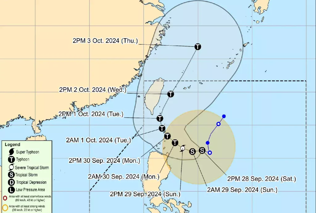
Tropical Storm Julian has slightly intensified as it continues its west-northwestward movement over the Philippine Sea, currently located approximately 380 km east of Aparri, Cagayan.
With maximum sustained winds of 75 km/h and gustiness of up to 90 km/h, Julian poses significant weather challenges in the region.
Current Conditions:
- Location of Center: 380 km East of Aparri, Cagayan (18.6°N, 125.2°E)
- Central Pressure: 996 hPa
- Present Movement: West northwestward at 15 km/h
- Wind Extent: Strong to gale-force winds extend outward up to 420 km from the center.
Tropical Cyclone Wind Signals in Effect:

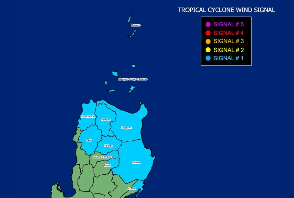
TCWS No. 1 is currently raised in the following areas, indicating strong winds (39 to 61 km/h) expected within 36 hours:
- Affected Areas: Batanes, Cagayan (including Babuyan Islands), Isabela, Apayao, Kalinga, eastern portions of Mountain Province and Ifugao, Ilocos Norte, and the northern portion of Aurora (Dilasag, Casiguran).
Potential impacts include minimal to minor threats to life and property. Residents are advised to take necessary precautions.
Heavy Rainfall Outlook:
As per Weather Advisory No. 7, heavy rainfall is anticipated due to Tropical Storm Julian. Areas experiencing strong winds may also see localized heavy rains, which can lead to flash floods and landslides.
Hazards Affecting Coastal Waters:
24-Hour Sea Condition Outlook:
- Very Rough Sea Conditions:
- Up to 6.0 m over Batanes
- Up to 5.0 m over Babuyan Islands
- Rough Sea Conditions:
- Up to 4.0 m over the northern seaboard of mainland Cagayan
- Up to 3.5 m over the northern seaboard of Ilocos Norte
- Mariners are advised to remain in port or seek safe shelter.
Traveling in small seacrafts is highly discouraged under these conditions.
Track and Intensity Outlook:

Tropical Storm Julian is expected to move west-southwestward through September 29 and then generally northwestward toward the Batanes-Babuyan Islands area. A landfall or close approach is highly likely from Monday through Tuesday early morning. As it continues to intensify, Julian is forecasted to reach typhoon category by Monday, with the possibility of rapid intensification to super typhoon status.
Public Advisory: Given these developments, the public and disaster risk management offices are urged to take all necessary measures to protect lives and property. Residents in high-risk areas should heed evacuation orders and instructions from local officials. For updated weather information, please monitor advisories from your local PAGASA Regional Services Division.
