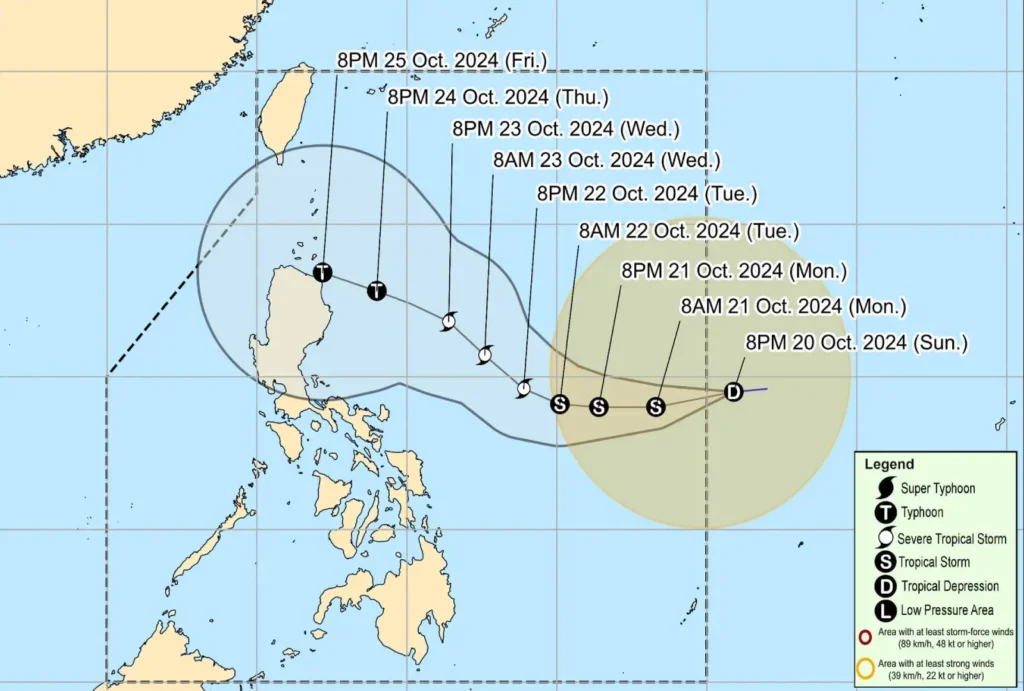
The low-pressure area (LPA) outside the Philippine Area of Responsibility (PAR) has developed into a tropical depression and is now moving towards the country.
As of 10:00 PM, the center of the tropical depression was located 1,255 km east of Southeastern Luzon, with maximum sustained winds of 55 km/h and gusts of up to 70 km/h.
The depression is moving westward at 30 km/h.
This weather disturbance is expected to enter PAR early tomorrow morning (October 21) and will be locally named “Kristine.”
The tropical depression is predicted to strengthen into a tropical storm within the next 12 hours, reaching severe tropical storm status by Tuesday afternoon or evening.
It may further intensify into a typhoon by Thursday, October 24, prior to making landfall over the northeastern portion of Cagayan on Friday evening, October 25.
Sea Conditions and Marine Warnings
Moderate to rough seas are expected in several coastal areas over the next 24 hours, with wave heights reaching up to 3.5 meters in Batanes, the Babuyan Islands, Isabela, and the eastern seaboard of Cagayan.
Mariners operating small vessels are strongly advised to avoid venturing into these waters, especially if inexperienced or ill-equipped.
Meanwhile, seas of up to 2.5 meters are forecast along the coasts of Ilocos Norte, Aurora, Quezon, Bicol Region, and the southern seaboard of Davao Region.
Forecast Track and Outlook

The tropical depression is forecast to continue moving westward until Tuesday morning before shifting west-northwestward to northwestward.
Intensification is likely due to favorable sea surface temperatures and low wind shear in the region.
The public is advised to monitor further updates as shifts in the cyclone’s track could still occur in the coming days.
Authorities are urging local disaster risk management offices and residents in affected areas to prepare for heavy rainfall, strong winds, and rough seas.
