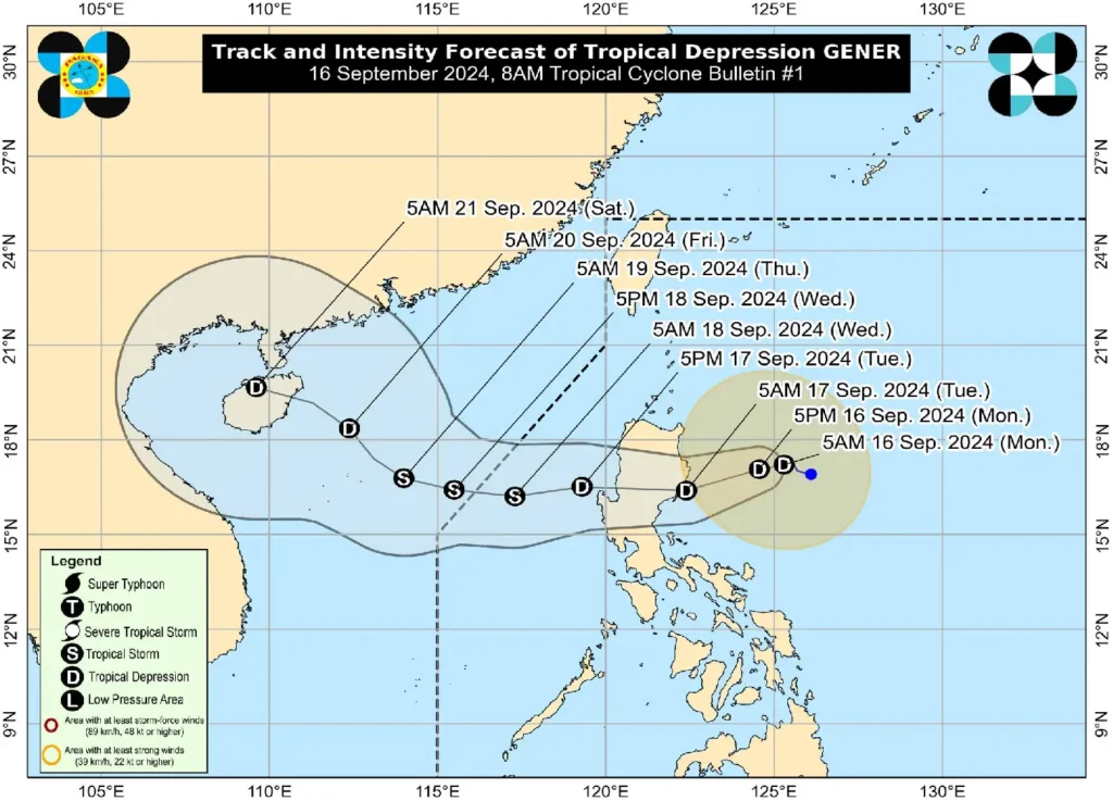
The low-pressure area east of Aurora has intensified into Tropical Depression “Gener,” with its center located 315 km east-northeast of Casiguran, Aurora as of 7:00 AM today. “Gener” is currently moving west-northwestward at 10 km/h, packing maximum sustained winds of 45 km/h and gusts up to 55 km/h. Strong winds extend outward up to 360 km from the center.
Tropical Cyclone Wind Signal No. 1 Raised
The Philippine Atmospheric, Geophysical, and Astronomical Services Administration (PAGASA) has issued Tropical Cyclone Wind Signal (TCWS) No. 1 for several provinces in Luzon, including parts of Cagayan, Isabela, Quirino, Apayao, Kalinga, Mountain Province, Ifugao, Aurora, Nueva Ecija, and Quezon. Areas under TCWS No. 1 can expect strong winds of 39 to 61 km/h within 36 hours, with minimal to minor damage possible to life and property.
Heavy Rainfall and Winds Expected
The Southwest Monsoon, enhanced by both “Gener” and Tropical Depression “PULASAN,” will bring heavy rains and strong winds over parts of MIMAROPA, Bicol Region, Visayas, Zamboanga Peninsula, Northern Mindanao, Caraga, and Davao Region. Gale warnings have also been issued for various coastal areas, making sea travel risky, particularly for small seacrafts.
Track and Intensity Forecast

“Gener” is forecast to make landfall over either Isabela or Aurora within the next 24 hours, with the storm potentially reaching Tropical Storm intensity by Wednesday after moving into the West Philippine Sea. The storm is expected to exit the Philippine Area of Responsibility (PAR) by Wednesday, before weakening into a Tropical Depression as it heads toward Hainan, China.
Residents and disaster preparedness teams are advised to stay alert and follow local advisories regarding evacuation and safety measures.
