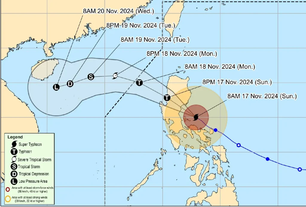
17 November 2024, 11:00 AM — Super Typhoon Pepito (international name: MAN-YI) maintains its strength and continues to threaten Aurora and Northern Quezon, bringing extreme winds and a significant risk of severe weather impacts to affected areas.
The center of the storm was located at 120 km east southeast of Baler, Aurora, as of 10:00 AM.
It carries maximum sustained winds of 185 km/h near the center and gusts reaching up to 230 km/h, moving northwest at 20 km/h.
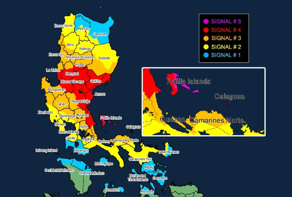
Current Alerts and Wind Signals

Tropical Cyclone Wind Signal No. 5
- Luzon: Eastern portion of Polillo Islands (Burdeos, Patnanungan, Jomalig)
Tropical Cyclone Wind Signal No. 4
- Luzon: Aurora, Quirino, Nueva Vizcaya, southern portion of Ifugao (Kiangan, Lamut, Tinoc, Asipulo, Lagawe), southern portion of Benguet (Bokod, Itogon, Tuba, Baguio City, Kabayan, La Trinidad, Sablan, Tublay, Kapangan, Atok), southern portion of La Union (Burgos, Naguilian, Bauang, Caba, Tubao, Pugo, Aringay, Santo Tomas, Rosario, Agoo, Bagulin, City of San Fernando), eastern portion of Pangasinan (Sison, Tayug, Binalonan, San Manuel, Umingan, Asingan, San Quintin, Santa Maria, Natividad, San Nicolas, Balungao, Pozorrubio, Laoac, San Jacinto, San Fabian, Manaoag, City of Urdaneta, Villasis, Rosales), eastern portion of Nueva Ecija (General Tinio, Gabaldon, Laur, Bongabon, Palayan City, Pantabangan, Rizal, General Mamerto Natividad, Lupao, San Jose City, Llanera, Carranglan), northern portion of Quezon (General Nakar, Infanta) including the rest of Polillo Islands, Calaguas Islands
Tropical Cyclone Wind Signal No. 3
- Luzon: Southern portion of Isabela (San Agustin, Jones, Echague, San Guillermo, Angadanan, Alicia, San Mateo, Ramon, San Isidro, City of Santiago, Cordon, Dinapigue, Roxas, San Manuel, Aurora, Cabatuan, City of Cauayan, Luna), rest of Ifugao, Mountain Province, southern portion of Abra (Tubo, Luba, Pilar, Villaviciosa, San Isidro, Pidigan, Langiden, San Quintin), Ilocos Sur, rest of Benguet, rest of La Union, rest of Pangasinan, northern portion of Zambales (Santa Cruz, Candelaria, Masinloc, Palauig), Tarlac, rest of Nueva Ecija, northern portion of Pampanga (Candaba, Arayat, Magalang, San Luis, San Simon, Mexico, Santa Ana, Apalit, Santo Tomas, City of San Fernando, Mabalacat City, Angeles City), northern portion of Bulacan (Norzagaray, San Miguel, San Ildefonso, San Rafael, Doña Remedios Trinidad, Angat, City of San Jose del Monte, Santa Maria, Pandi, Baliuag, Bustos, Pulilan, Plaridel), northern portion of Rizal (Pililla, Tanay, City of Antipolo, Rodriguez, Baras, San Mateo, Morong, Teresa), eastern portion of Laguna (Santa Maria, Famy, Mabitac, Pakil, Pangil, Siniloan, Paete, Kalayaan, Lumban, Cavinti), central and eastern portion of Quezon (Real, Perez, Calauag, Alabat, Quezon, Mauban, Sampaloc), western portion of Camarines Norte (Santa Elena, Labo, Capalonga, Paracale, Vinzons, San Vicente, Talisay, Daet, Jose Panganiban)
Tropical Cyclone Wind Signal No. 2
- Luzon: Rest of Isabela, southwestern portion of mainland Cagayan (Enrile, Tuao, Solana, Tuguegarao City, Piat, Rizal), Kalinga, southern portion of Apayao (Conner, Kabugao), rest of Abra, Ilocos Norte, rest of Zambales, Bataan, rest of Pampanga, rest of Bulacan, Metro Manila, rest of Rizal, Cavite, rest of Laguna, rest of Quezon, rest of Camarines Norte, Camarines Sur, western portion of Catanduanes (Pandan, Caramoran, San Andres)
Tropical Cyclone Wind Signal No. 1
- Luzon: Rest of mainland Cagayan, rest of Apayao, Batangas, northern portion of Occidental Mindoro (Abra de Ilog, Paluan) including Lubang Islands, northern portion of Oriental Mindoro (Puerto Galera, San Teodoro, Naujan, Baco, Victoria, Socorro, Pinamalayan, Gloria, Pola, City of Calapan), northern portion of Romblon (Cajidiocan, San Fernando, Magdiwang, Romblon, Banton, Corcuera, Concepcion, San Andres, Calatrava, San Agustin), Marinduque, northern portion of Masbate (City of Masbate, Mobo, Aroroy, Baleno) including Burias and Ticao Islands, Albay, Sorsogon, rest of Catanduanes
Heavy Rainfall and Coastal Hazards
The typhoon is set to bring intense rainfall over its path, with a high risk of life-threatening storm surges.
Coastal areas, including Ilocos Region, Central Luzon, Metro Manila, CALABARZON, Marinduque, and Bicol, may experience peak surges exceeding 3 meters over the next 48 hours.
Rough to very rough sea conditions are anticipated, with wave heights up to 14 meters near Polillo Islands and Aurora.
Expected Track and Impacts

Pepito is forecast to make landfall in Aurora this afternoon and cross Central and Northern Luzon through the Sierra Madre, Caraballo, and Cordillera mountains, exiting Luzon tonight.
It may weaken over land but will continue to affect nearby areas with strong winds and rain.
As it moves into the West Philippine Sea, further weakening is expected due to an incoming northeasterly wind surge.
Safety and Precautions
Residents in areas under high wind signals should prepare for extreme weather and consider preemptive evacuations if necessary.
Sea travel remains extremely dangerous across affected coastal waters, and mariners are advised to seek shelter. Stay tuned for updates and heed warnings from local authorities to ensure safety.
