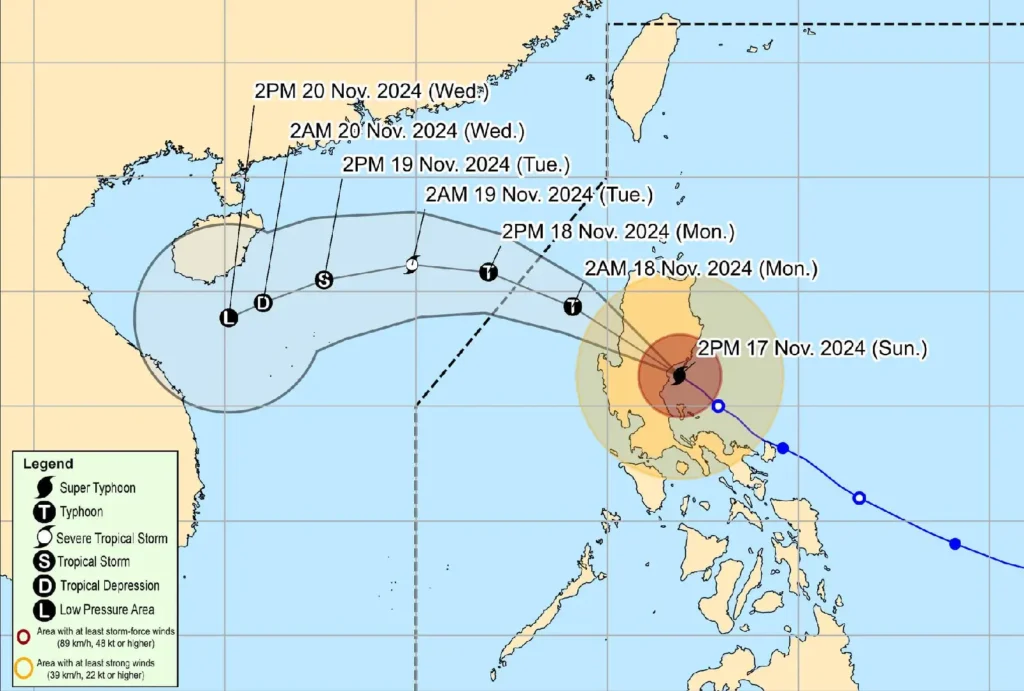
17 November 2024, 5:00 PM – Super Typhoon Pepito (international name: MAN-YI) has made its second landfall in Dipaculao, Aurora, at approximately 3:20 PM today and is currently over the vicinity of Nagtipunan, Quirino.
Typhoon Details:
- Location of Eye: As of 4:00 PM, the center was pinpointed over Nagtipunan, Quirino (16.1°N, 121.5°E), based on all available data, including the Baler Weather Radar.
- Intensity: Pepito carries maximum sustained winds of 185 km/h near its center, with gusts reaching up to 305 km/h and a central pressure of 935 hPa.
- Movement: The typhoon is moving northwestward at 25 km/h.
- Wind Extent: Typhoon-force winds extend up to 300 km from the center.
Tropical Cyclone Wind Signals (TCWS) in Effect:

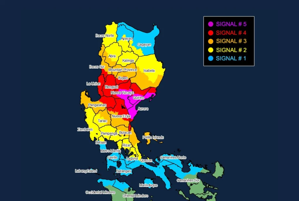
TCWS No. 5
- Areas: Central Aurora, southern Quirino, southern Nueva Vizcaya
- Wind Speeds: ≥185 km/h
- Impact: Extreme threat to life and property
TCWS No. 4
- Areas: Rest of Aurora, rest of Nueva Vizcaya, rest of Quirino, parts of Ifugao, Benguet, La Union, parts of Ilocos Sur, eastern Pangasinan, northern Nueva Ecija
- Wind Speeds: 118–184 km/h
- Impact: Severe threat to life and property
TCWS No. 3
- Areas: Southern Isabela, rest of Ifugao, Mountain Province, southern Kalinga, southern Abra, northern Quezon including Polillo Islands, and others
- Wind Speeds: 89–117 km/h
- Impact: Significant threat to life and property
TCWS No. 2
- Areas: Southwestern Cagayan, Kalinga, Apayao, Ilocos Norte, Zambales, Bataan, Metro Manila, parts of Quezon and more
- Wind Speeds: 62–88 km/h
- Impact: Moderate threat to life and property
TCWS No. 1
- Areas: Remaining parts of Cagayan, Apayao, Bataan, Cavite, Batangas, and several provinces in Southern Luzon
- Wind Speeds: 39–61 km/h
- Impact: Minimal threat to life and property
Hazards:
Heavy Rainfall: Expect heavy to intense rain, especially in areas along the storm’s path.
Severe Winds: Typhoon-force winds may bring extreme damage, particularly in Aurora and nearby regions.
Storm Surge: Life-threatening storm surges up to 3.0 meters may affect exposed coastal areas of Ilocos, southeastern Cagayan, Isabela, Central Luzon, Metro Manila, and parts of Batangas and Quezon.
Sea Conditions:
Very Rough Seas: Up to 9.0 meters along Aurora’s coast, 8.0 meters off Isabela, and 6.0 meters along Cagayan’s eastern seaboard. Sea travel remains dangerous for all vessels.
Forecast Track and Intensity:

Pepito will traverse upland regions in Central and Northern Luzon and is expected to weaken due to land interaction.
By tomorrow morning, it will emerge over the West Philippine Sea and exit the Philippine Area of Responsibility by late morning or noon.
As Pepito heads westward, an incoming northeasterly wind surge will further weaken it.
