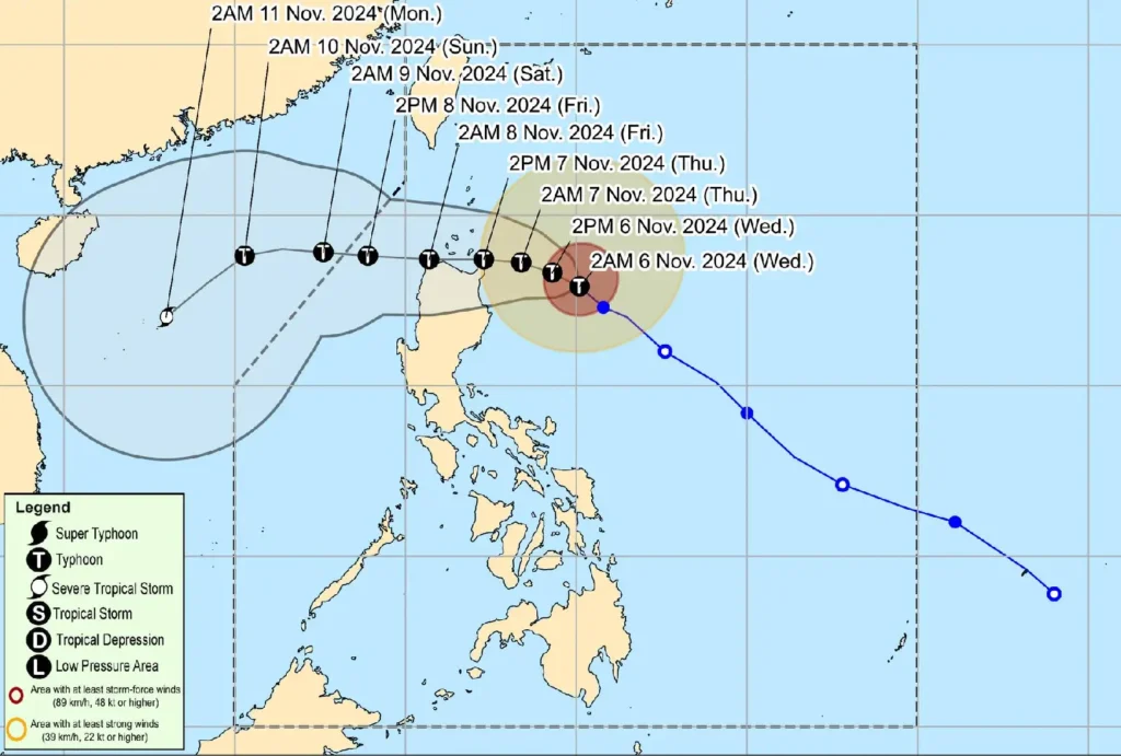
The Philippine Atmospheric, Geophysical and Astronomical Services Administration (PAGASA) issued the latest update on Typhoon Marce (international name: Yinxing), which has maintained its strength as it moves northwestward across the Philippine Sea.
Marce’s center was last located approximately 345 km east of Tuguegarao City, Cagayan, packing maximum sustained winds of 140 km/h near the center, with gusts reaching up to 170 km/h.
Current Typhoon Path and Intensity Marce is traveling northwest at 15 km/h, with strong winds extending up to 400 km from the center.
The typhoon is expected to intensify further, potentially reaching peak strength later today.
By Thursday, Marce may make landfall or pass close to the Babuyan Islands or the northern part of mainland Cagayan.
Wind Alerts and Areas Affected

- Signal No. 2: Gale-force winds between 62-88 km/h are expected within 24 hours, posing minor to moderate risks to life and property. Affected areas include the eastern Babuyan Islands (Camiguin and Babuyan Islands) and the northeastern parts of Cagayan (Santa Ana, Gonzaga, Lal-Lo, Santa Teresita, Buguey).
- Signal No. 1: Strong winds of 39-61 km/h could impact Batanes, the remaining areas of Cagayan, Ilocos Norte, Ilocos Sur, Apayao, Abra, Kalinga, Mountain Province, Ifugao, parts of Benguet, Isabela, Nueva Vizcaya, Quirino, and parts of Aurora. Minimal to minor impacts on life and property are anticipated within 36 hours.
Coastal and Sea Condition Warnings
A Gale Warning has been issued for the seaboards of Northern and Central Luzon due to hazardous sea conditions, with wave heights projected as follows:
- Up to 8.0 meters along northeastern Cagayan and the eastern Babuyan Islands.
- Up to 7.0 meters in other areas around Cagayan and Babuyan Islands.
- Up to 6.0 meters along northern Ilocos Norte and northeastern Isabela. Due to dangerous sea conditions, mariners are advised to avoid sea travel, especially small vessels and motorbancas.
Storm Surge and Rainfall Hazards
Residents in low-lying or coastal areas of Batanes, Cagayan, Isabela, Ilocos Norte, and Ilocos Sur face a moderate to high risk of storm surges between 2.0-3.0 meters over the next 48 hours.
Heavy rainfall may also affect these regions, with flash floods and landslides possible in susceptible areas.
Track and Forecast

Marce is projected to decelerate over the Philippine Sea today, continuing its west-northwestward movement.
As it approaches Northern Luzon, residents in affected areas are urged to monitor updates and heed local authorities’ instructions, especially in areas with evacuation orders.
