Issued: 2:00 AM, September 30, 2024
Valid Until: 5:00 AM, September 30, 2024
Typhoon Julian (Krathon) continues to intensify as it moves west-northwestward over the Balintang Channel, further threatening Northern Luzon, particularly the Batanes and Babuyan Islands.
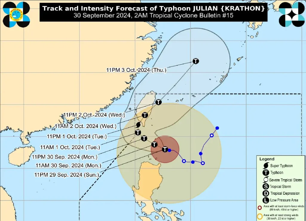
As of 1:00 AM, Julian’s center was located 95 kilometers southeast of Basco, Batanes, with maximum sustained winds of 155 km/h and gusts reaching 190 km/h.
Current Situation:
- Location of Typhoon: 95 km Southeast of Basco, Batanes (19.8°N, 122.6°E)
- Intensity: Maximum sustained winds of 155 km/h; gusts up to 190 km/h; central pressure at 955 hPa.
- Movement: West northwestward at 15 km/h.
- Wind Extent: Strong to typhoon-force winds extend up to 560 km from the center.
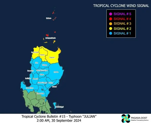
Tropical Cyclone Wind Signals (TCWS) in Effect:

- TCWS No. 4:
- Affected Areas: Batanes and the northern portion of Babuyan Islands (Babuyan and Calayan Islands)
- Wind Threat: Typhoon-force winds (118 to 184 km/h)
- Warning Lead Time: 12 hours
- Impact: Significant to severe threat to life and property
- TCWS No. 3:
- Affected Areas: Rest of Babuyan Islands and northeastern mainland Cagayan (Santa Ana)
- Wind Threat: Storm-force winds (89 to 117 km/h)
- Warning Lead Time: 18 hours
- Impact: Moderate to significant threat to life and property
- TCWS No. 2:
- Affected Areas: Rest of mainland Cagayan, Apayao, and Ilocos Norte
- Wind Threat: Gale-force winds (62 to 88 km/h)
- Warning Lead Time: 24 hours
- Impact: Minor to moderate threat to life and property
- TCWS No. 1:
- Affected Areas: Ilocos Sur, La Union, Pangasinan, Abra, Kalinga, Ifugao, Mountain Province, Benguet, Isabela, Nueva Vizcaya, Quirino, Aurora, Polillo Islands, and parts of Nueva Ecija
- Wind Threat: Strong winds (39 to 61 km/h)
- Warning Lead Time: 36 hours
- Impact: Minimal to minor threat to life and property
Other Hazards:
- Heavy Rainfall: Monitor Weather Advisory No. 15 for updated rainfall outlooks. Flooding and landslides may occur in affected areas.
- Coastal Inundation: Moderate to high risk of life-threatening storm surge is expected in low-lying coastal areas of Batanes, Babuyan Islands, and northern Cagayan over the next 48 hours.
Sea Conditions:
- Gale Warning: Rough to very rough seas up to 14 meters are expected along the seaboards of Batanes and Babuyan Islands, making sea travel extremely dangerous. Mariners are advised to remain in port or seek safe harbor immediately.
Track and Intensity Outlook:

Typhoon Julian is forecast to continue moving west-northwestward through Tuesday, potentially making landfall or passing very close to Batanes this morning or afternoon.
By October 1, Julian is expected to turn northward toward Taiwan, where it could make another landfall as it reaches super typhoon strength.
Public Advisory:
Residents in the affected areas are urged to take all necessary precautions to protect life and property.
Evacuation may be necessary in highly susceptible areas, and local authorities’ advisories should be followed strictly.
Stay updated on the latest warnings issued by PAGASA and local disaster management offices.
The next tropical cyclone bulletin will be issued at 5:00 AM today. Stay tuned for further updates.
