Severe Tropical Storm Nika (international name: Toraji) has intensified and is moving west-northwest toward Luzon, threatening multiple provinces with strong winds, heavy rainfall, and hazardous sea conditions.
Current Status and Location
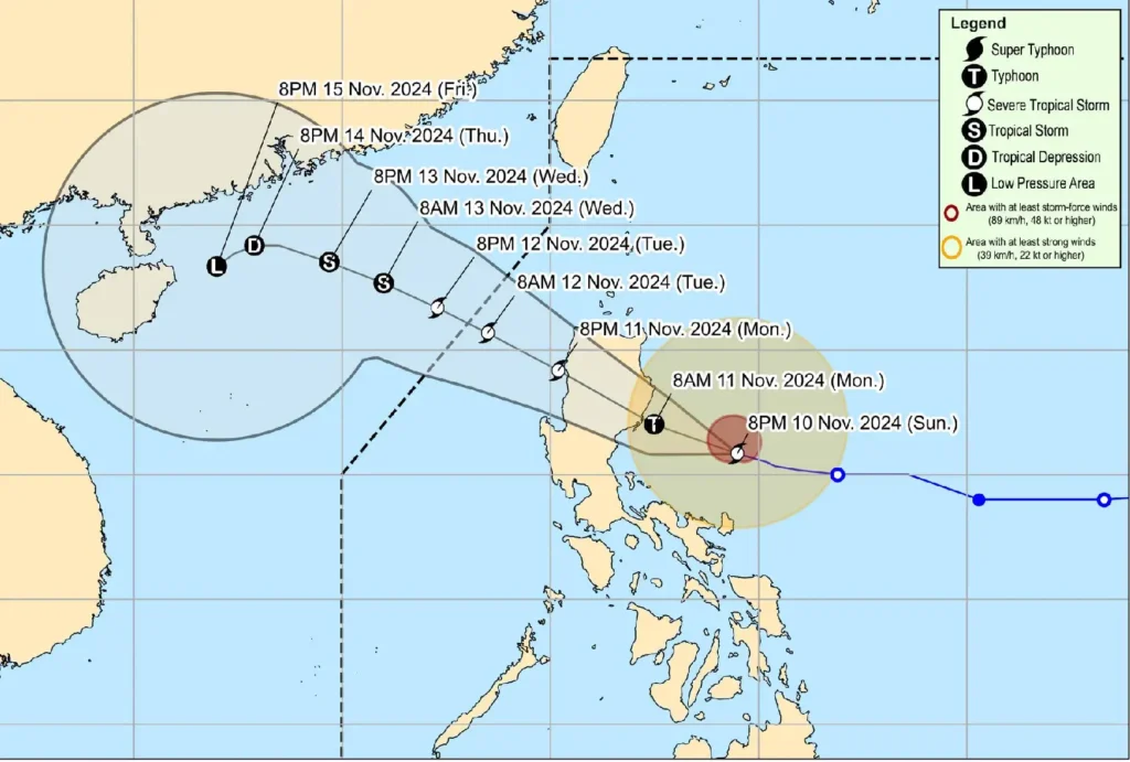
As of 4:00 PM today, the center of Severe Tropical Storm Nika was located 265 km east of Baler, Aurora. The storm has maximum sustained winds of 110 km/h near the center, gusts reaching up to 135 km/h, and a central pressure of 980 hPa.
Moving west-northwest at a speed of 15 km/h, Nika’s strong to storm-force winds extend up to 340 km from the center.
Tropical Cyclone Wind Signals (TCWS)

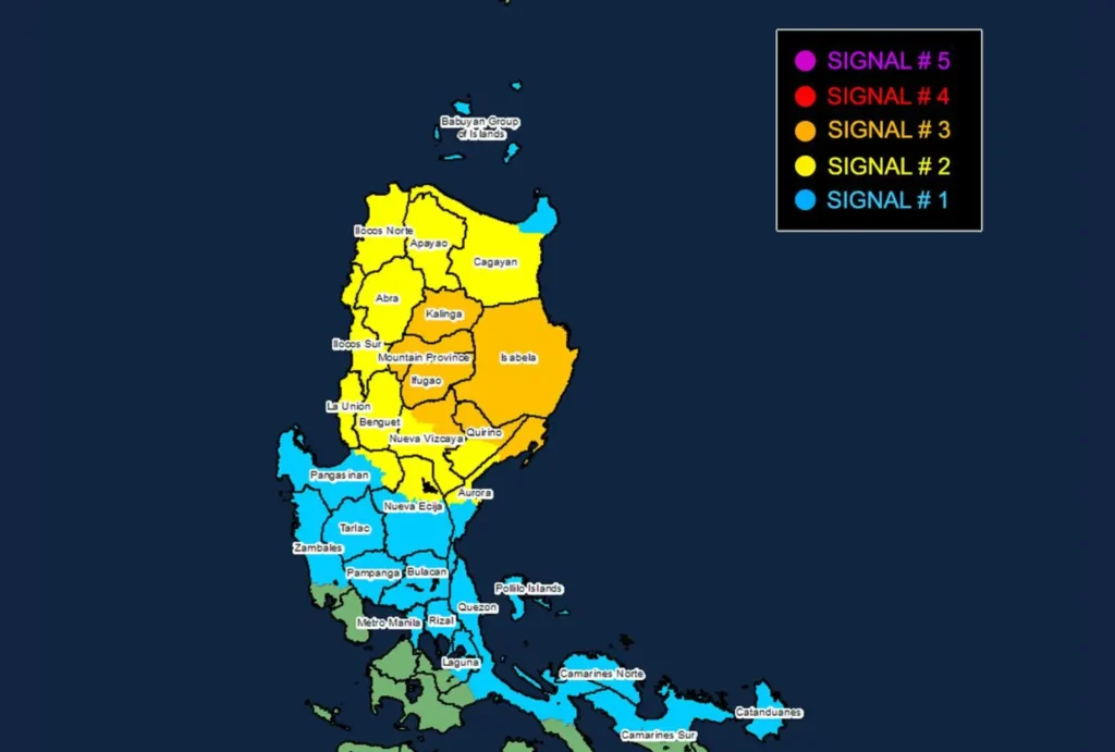
- TCWS No. 3: Storm-force winds (89-117 km/h) are expected within 18 hours, posing moderate to significant threats to life and property. This signal is in effect for areas including Isabela, northern portions of Nueva Vizcaya and Quirino, Kalinga, Mountain Province, Ifugao, and northern Aurora.
- TCWS No. 2: Gale-force winds (62-88 km/h) are expected within 24 hours, with minor to moderate threats. Affected provinces include Ilocos Norte, Ilocos Sur, La Union, parts of Pangasinan, Apayao, Abra, Benguet, portions of Cagayan, and central Aurora.
- TCWS No. 1: Strong winds (39-61 km/h) expected within 36 hours, with minimal to minor threats. This warning covers Metro Manila, Rizal, parts of Zambales, Nueva Ecija, Bulacan, and the eastern section of Laguna, among others.
Heavy Rainfall and Flooding Concerns
Heavy rain is anticipated, particularly in areas under Wind Signals No. 2 and No. 3. Residents are advised to prepare for potential flooding, landslides, and overflowing rivers. Authorities have urged those in flood-prone and mountainous areas to heed evacuation orders and stay updated on local advisories.
Coastal and Sea Hazards
A significant storm surge risk exists for low-lying coastal areas, especially in Ilocos Norte, Cagayan, and Quezon, including the Polillo Islands. Gale warnings are also in effect:
- Up to 8.0 meters high waves: Isabela and northern Aurora’s seaboards.
- Up to 5.5 meters: The remaining seaboards of Aurora and parts of Camarines Norte.
- Up to 4.5 meters: Coastal areas of Cagayan and Ilocos provinces.
Mariners, particularly those operating small or inadequately equipped vessels, are advised to remain in port. Conditions are deemed extremely dangerous for sea travel across various affected regions, with waves reaching up to 8 meters high.
Forecast Track and Intensity

Nika is forecast to make landfall in Isabela or northern Aurora tomorrow morning or early afternoon. The storm is expected to intensify further, possibly reaching typhoon status before landfall, with peak winds of 130 km/h.
As Nika crosses Luzon, a period of weakening is anticipated, but re-intensification is possible once it emerges over the West Philippine Sea.
Safety and Preparedness
Authorities urge the public to prepare for strong winds, heavy rainfall, and the possibility of storm surges. Residents in threatened areas should stay indoors, secure loose objects, and stock up on emergency supplies.
Those in vulnerable coastal and low-lying areas should move to higher ground or evacuation centers as directed by local officials.
