
Typhoon Pepito (international name: Man-Yi) has weakened slightly as it traverses the coastal waters near La Union and Pangasinan, but it continues to pose a significant threat, with typhoon-force winds extending up to 300 kilometers from its center.
As of 10:00 PM today, the Philippine Atmospheric, Geophysical and Astronomical Services Administration (PAGASA) located the eye of Typhoon Pepito over the waters of San Fernando, La Union, with maximum sustained winds of 155 km/h and gusts of up to 255 km/h.
It is moving west-northwest at 25 km/h, with a central pressure of 950 hPa.
Tropical Cyclone Wind Signals (TCWS) in Effect:
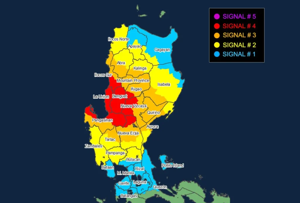
- Signal No. 4: Typhoon-force winds expected in the southern parts of Ilocos Sur, all of La Union, northern Pangasinan, Benguet, portions of Ifugao, and parts of Nueva Vizcaya and Nueva Ecija. These areas face severe threats to life and property.
- Signal No. 3: Storm-force winds will impact remaining areas in Pangasinan, parts of Abra, Kalinga, Mountain Province, Ifugao, Isabela, Quirino, Nueva Vizcaya, Tarlac, Nueva Ecija, and Aurora, bringing moderate to significant damage.
- Signal No. 2: Gale-force winds are expected across Ilocos Norte, Apayao, the rest of Abra, Kalinga, Cagayan, Isabela, Aurora, Zambales, and parts of Central Luzon and Bulacan.
- Signal No. 1: Strong winds will affect Metro Manila, Rizal, Cavite, Laguna, northern Quezon, Batangas, and parts of mainland Cagayan and Apayao.
Coastal Hazards and Sea Conditions
A High Risk of storm surge remains for the coastal areas of the Ilocos Region, southeastern mainland Cagayan, Isabela, Central Luzon, Metro Manila, Cavite, Quezon (including Polillo Islands), and Camarines Norte.
Residents are advised to heed local warnings and evacuation advisories.
Sea conditions remain dangerous, with rough to very rough seas along the eastern and western seaboards of Luzon, posing a significant threat to all types of sea vessels.
Mariners are urged to remain in port and take necessary precautions.
Outlook and Path
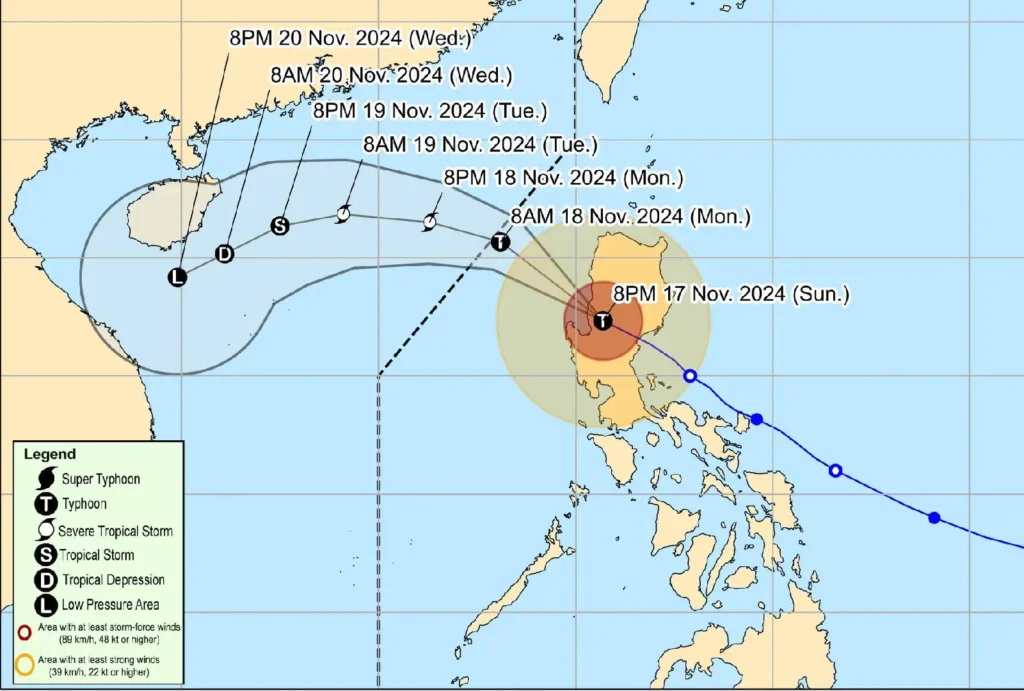
Typhoon Pepito is forecast to continue moving over the West Philippine Sea and may exit the Philippine Area of Responsibility (PAR) tomorrow morning or by noon.
Further weakening is expected as it encounters an incoming northeasterly wind surge.
Residents are reminded that heavy rain, severe winds, and storm surges remain possible even outside the predicted landfall area. For detailed rainfall advisories and local warnings, stay tuned to PAGASA updates.