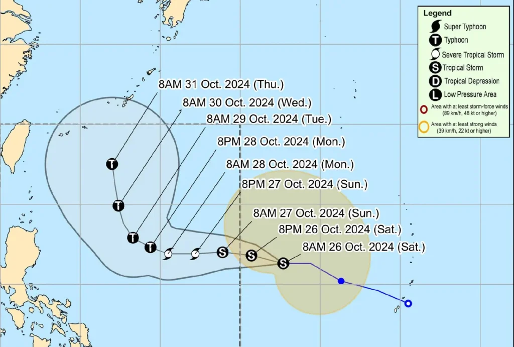
Tropical Storm Kong-Rey remains strong as it moves westward and is projected to enter the Philippine Area of Responsibility (PAR) by late tonight or early tomorrow morning, where it will be assigned the local name “Leon.”
At 10:00 AM, Kong-Rey’s center was estimated 1,630 km east of Central Luzon, carrying maximum sustained winds of 65 km/h and gusts reaching up to 80 km/h.
The storm is moving westward at 30 km/h, with strong to gale-force winds extending up to 630 km from its center.

Kong-Rey is forecasted to continue its westward path over the weekend, shift to a west northwest direction by Monday, and eventually turn north northwest in the following days.
Although it will remain far from the Philippine landmass, there is a possibility of the storm’s path adjusting, especially on days four and five of its projected course.
Kong-Rey is expected to intensify gradually, reaching the severe tropical storm category on Sunday and possibly becoming a typhoon by Monday.
Outer rainbands from Kong-Rey may impact Extreme Northern Luzon, and the storm may also amplify the southwesterly windflow previously influenced by Severe Tropical Storm Kristine. This may bring rain to the western sections of Southern Luzon, Visayas, and Mindanao.
Mariners are advised of moderate to rough seas along the northern and eastern coasts of Luzon and the eastern seaboard of Visayas, where monitoring and caution are recommended.
Disaster risk reduction offices and the public are urged to stay updated on Kong-Rey’s progress as PAGASA continues to monitor the tropical cyclone’s movement and potential impacts.
The next tropical cyclone advisory will be issued by PAGASA at 11:00 PM tonight unless an intermediate update is necessary.
