Issued at 8:00 PM, 17 November 2024 – Typhoon Pepito (Man-Yi) has weakened as it moves over Nueva Vizcaya, but it remains a formidable system, bringing strong winds and heavy rains across multiple provinces in Luzon.
Current Situation
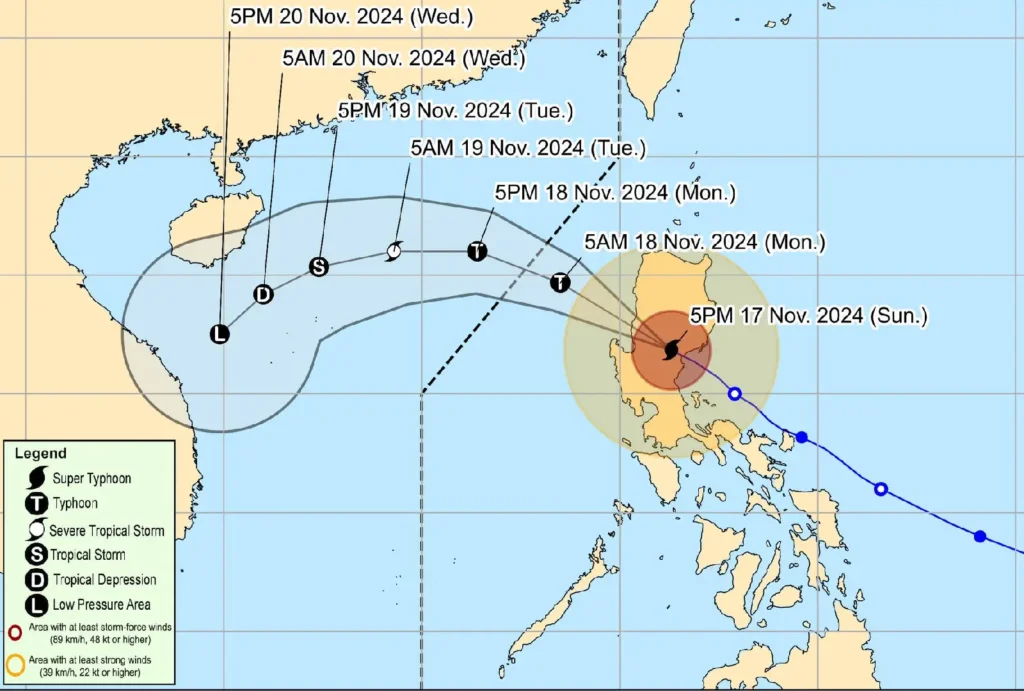
As of 7:00 PM today, the center of Typhoon Pepito was located near Santa Fe, Nueva Vizcaya (16.2°N, 120.9°E).
It is moving west-northwest at a speed of 25 km/h, with maximum sustained winds of 165 km/h and gusts up to 275 km/h.
Typhoon-force winds extend up to 300 kilometers from the center.
Tropical Cyclone Wind Signals

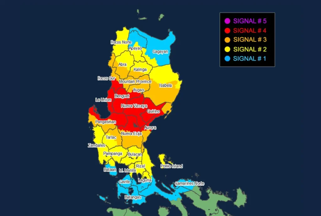
The areas affected by Typhoon Pepito are extensive. Under Tropical Cyclone Wind Signal No. 4, with typhoon-force winds expected within 12 hours, the following regions are at significant risk: central Aurora (Dinalungan, Dipaculao, Baler, Maria Aurora), Quirino, Nueva Vizcaya, southern Ifugao (Kiangan, Lamut, Tinoc, Asipulo, Lagawe), Benguet, southern Ilocos Sur (Alilem, Sugpon, Suyo, Santa Cruz, Tagudin, City of Candon, Santa Lucia, Salcedo, Galimuyod, Cervantes, Sigay), La Union, and the northern and eastern parts of Pangasinan (Sison, Tayug, Binalonan, San Manuel, Asingan, San Quintin, Santa Maria, Natividad, San Nicolas, Balungao, Pozorrubio, Laoac, San Jacinto, San Fabian, Manaoag, City of Urdaneta, Rosales, Umingan, Mangaldan, Mapandan, Villasis, Santo Tomas, Dagupan City, Anda, Bolinao, Bani, City of Alaminos, Lingayen, Binmaley, Sual, Labrador), as well as northern Nueva Ecija (Bongabon, Pantabangan, Rizal, Lupao, San Jose City, Carranglan, Science City of Muñoz, Talugtug, Cuyapo, Llanera).
Areas under Signal No. 3, facing storm-force winds with a lead time of 18 hours, include southern Isabela (San Agustin, Jones, Echague, San Guillermo, Angadanan, Alicia, San Mateo, Ramon, San Isidro, City of Santiago, Cordon, Dinapigue, Roxas, Aurora, Cabatuan, City of Cauayan, Luna, San Mariano, Benito Soliven, Naguilian, Reina Mercedes, San Manuel, Burgos), the rest of Ifugao, Mountain Province, southern Kalinga (Pasil, Tanudan, Lubuagan, Tinglayan), southern Abra (Tubo, Luba, Pilar, Villaviciosa, San Isidro, Pidigan, Langiden, San Quintin, Bangued, Manabo, Boliney, Peñarrubia, Bucloc, Sallapadan, Bucay), the rest of Ilocos Sur, the remaining parts of Pangasinan, the northern and eastern parts of Tarlac (Paniqui, La Paz, Moncada, City of Tarlac, Gerona, Pura, San Clemente, Santa Ignacia, Victoria, Camiling, Concepcion, Ramos, San Manuel, Anao), the rest of Nueva Ecija, and the rest of Aurora.
Regions under Signal No. 2, with gale-force winds and a lead time of 24 hours, include the rest of Isabela, southwestern mainland Cagayan (Enrile, Tuao, Solana, Tuguegarao City, Piat, Rizal), the rest of Kalinga, southern Apayao (Conner, Kabugao), the rest of Abra, Ilocos Norte, Zambales, the rest of Tarlac, northern Bataan (Orani, Abucay, Hermosa, Samal, Dinalupihan), Pampanga, Bulacan, Metro Manila, Rizal, northeastern Laguna (Kalayaan, Paete, Pangil, Pakil, Siniloan, Famy, Santa Maria, Mabitac), and northern Quezon (General Nakar, Infanta, Real), including Polillo Islands.
Lastly, under Signal No. 1, with strong winds expected within 36 hours, are mainland Cagayan, the rest of Apayao, the remainder of Bataan, Cavite, Laguna, Batangas, central Quezon (Calauag, Pitogo, Lucena City, Pagbilao, Tiaong, Lopez, Guinayangan, Unisan, Plaridel, Quezon, San Antonio, Alabat, Candelaria, Lucban, Sampaloc, Padre Burgos, Sariaya, City of Tayabas, Macalelon, Mauban, Dolores, Perez, Agdangan, Gumaca, Atimonan, Tagkawayan), Lubang Islands, and the western portion of Camarines Norte (Santa Elena, Paracale, Labo, Vinzons, Jose Panganiban, Capalonga).
Heavy Rainfall and Storm Surge
- Heavy rains may lead to flash floods and landslides, especially in mountainous and low-lying areas. The risk of storm surge is high along coastal regions, with peak surge heights exceeding 3.0 meters in areas like the Ilocos Region, southeastern mainland Cagayan, Isabela, Central Luzon, Metro Manila, Cavite, and Quezon.
- The public is advised to remain vigilant and heed warnings from local authorities.
Coastal Waters and Sea Conditions
- Gale Warnings remain in effect, with very rough to high seas expected along the eastern and western seaboards of Northern and Central Luzon. Sea waves could reach heights of up to 9.0 meters, especially along the seaboard of Aurora.
- Mariners are strongly urged to remain in port, and sea travel is highly discouraged for small seacrafts due to hazardous conditions.
Track and Intensity Outlook

Typhoon Pepito is expected to exit Luzon either tonight or early tomorrow morning via Pangasinan, La Union, or southern Ilocos Sur.
It may weaken but will remain at typhoon strength as it enters the West Philippine Sea. By Tuesday, Pepito could further weaken as it encounters an incoming northeasterly wind surge.
Residents in affected areas should continue monitoring updates and prepare accordingly, as Typhoon Pepito may still bring significant impacts beyond the immediate landfall region.
