Super Typhoon Pepito (international name: MAN-YI) continues to intensify as it moves across the Philippines.
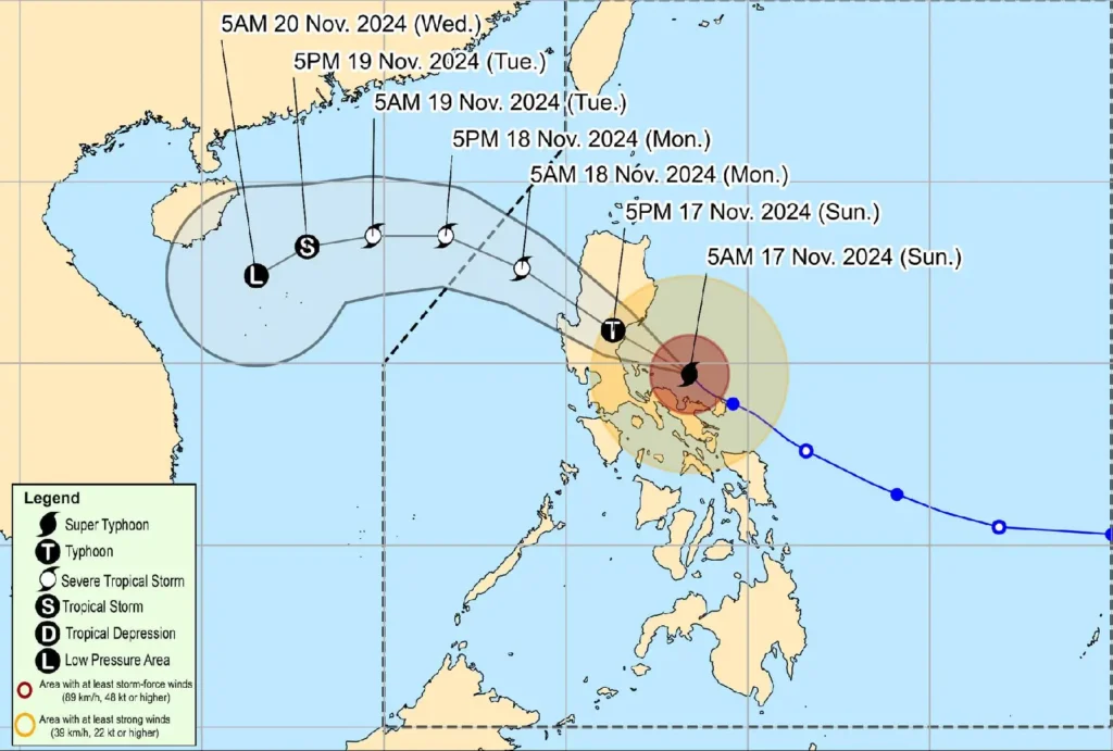
As of 7:00 AM today, the typhoon’s center was located over the coastal waters of Vinzons, Camarines Norte, just north of Calaguas Islands.
The storm is currently traveling northwestward at 15 km/h, bringing with it life-threatening winds and heavy rainfall that will impact much of Southern Luzon.
Current Storm Details:
- Location: 14.9°N, 123.1°E (North of Calaguas Islands, Camarines Norte)
- Intensity: Maximum sustained winds of 185 km/h near the center, with gusts reaching up to 255 km/h. Central pressure is at 925 hPa.
- Movement: Northwestward at 15 km/h
- Wind Extent: Strong to typhoon-force winds extend outwards up to 300 km from the center.
Typhoon Signal Updates:

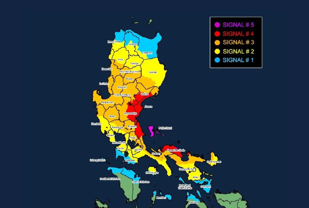
Several provinces are under varying levels of Tropical Cyclone Wind Signals (TCWS), with the most severe warnings in place.
TCWS No. 5:
- Eastern portion of Polillo Islands (Patnanungan, Jomalig)
- Calaguas Islands
TCWS No. 4:
- Northernmost portion of Camarines Sur (Siruma)
- Rest of Camarines Norte
- Northern portion of mainland Quezon (General Nakar, Infanta)
- Rest of Polillo Islands
- Central and southern portions of Aurora (Dingalan, San Luis, Maria Aurora, Baler, Dipaculao, Dinalungan)
- Eastern portion of Nueva Ecija (General Tinio, Gabaldon, Laur, Bongabon, Palayan City, Pantabangan, Rizal, General Mamerto Natividad)
- Southeastern portion of Nueva Vizcaya (Alfonso Castañeda)
- Southern portion of Quirino (Nagtipunan)
TCWS No. 3:
- Northern portion of Camarines Sur (Sipocot, Ragay, Magarao, Del Gallego, Libmanan, Naga City, Bombon, Lupi, Cabusao, Calabanga, Goa, San Jose, Lagonoy, Presentacion, Caramoan, Garchitorena, Tinambac, Canaman, Camaligan)
- Western portion of Catanduanes (Caramoran, Pandan, San Andres)
- Eastern portion of Quezon (Calauag, Guinayangan, Tagkawayan, Lopez, Quezon, Perez, Alabat, Gumaca, Plaridel, Atimonan, Mauban, Sampaloc, Real)
- Eastern portion of Laguna (Santa Maria, Famy, Mabitac, Pakil, Pangil, Siniloan, Paete, Kalayaan, Lumban, Cavinti)
- Eastern and central portions of Rizal (Pililla, Tanay, City of Antipolo, Rodriguez, Baras, San Mateo, Morong, Teresa)
- The rest of Aurora
- Eastern and central portions of Bulacan (Norzagaray, San Miguel, San Ildefonso, San Rafael, Doña Remedios Trinidad, Angat, City of San Jose del Monte, Santa Maria, Pandi, Baliuag, Bustos, Pulilan, Plaridel)
- Northeastern portion of Pampanga (Candaba, Arayat, Magalang, San Luis, San Simon, Mexico, Santa Ana, Apalit, Santo Tomas, City of San Fernando, Mabalacat City, Angeles City)
- Rest of Nueva Ecija
- Tarlac
- Northern portion of Zambales (Santa Cruz, Candelaria, Masinloc, Palauig)
- Rest of Nueva Vizcaya
- Rest of Quirino
- Southern portion of Isabela (San Agustin, Jones, Echague, San Guillermo, Angadanan, Alicia, San Mateo, Ramon, San Isidro, City of Santiago, Cordon)
- Central and southern portions of Ilocos Sur (Alilem, Sugpon, Cervantes, Suyo, Tagudin, Narvacan, Quirino, Sigay, Gregorio del Pilar, San Emilio, Santa Cruz, Salcedo, Banayoyo, City of Candon, Galimuyod, Santa Lucia, Lidlidda, Santa Maria, Burgos, Santiago, San Esteban, Nagbukel)
- La Union
- Pangasinan
- Benguet
- Ifugao
- Western portion of Mountain Province (Sabangan, Bauko, Tadian, Bontoc, Sagada, Besao, Sadanga, Barlig)
- Southern portion of Abra (Tubo, Luba, Pilar, Villaviciosa, San Isidro)
TCWS No. 2:
- Albay
- Northern portion of Marinduque (Santa Cruz, Boac, Mogpog, Torrijos)
- Rest of Quezon
- Rest of Laguna
- Rest of Rizal
- Cavite
- Northern portion of Batangas (City of Tanauan, Santo Tomas, Talisay, Lipa City, Malvar, Balete, Mataasnakahoy, Laurel, Padre Garcia, San Juan, Rosario)
- Metro Manila
- Bataan
- Rest of Pampanga
- Rest of Bulacan
- Rest of Zambales
- Southwestern portion of Cagayan (Enrile, Tuao, Solana, Tuguegarao City, Piat, Rizal)
- Rest of Isabela
- Rest of Abra
- Southern portion of Apayao (Conner, Kabugao)
- Kalinga
- Rest of Mountain Province
- Rest of Ilocos Sur
- Southern portion of Ilocos Norte (Pinili, City of Batac, Banna, Nueva Era, Badoc, Currimao, Marcos, Solsona, Dingras, Sarrat, Paoay, Laoag City, San Nicolas)
TCWS No. 1:
- Northern portion of Masbate (City of Masbate, Mobo, Aroroy, Baleno) including Ticao and Burias Islands
- Rest of Marinduque
- Northern portion of Romblon (Cajidiocan, San Fernando, Magdiwang, Romblon, Banton, Corcuera, Concepcion, San Andres, Calatrava, San Agustin)
- Northern portion of Oriental Mindoro (Puerto Galera, San Teodoro, Naujan, Baco, Victoria, Socorro, Pinamalayan, Gloria, Pola, City of Calapan)
- Northern portion of Occidental Mindoro (Sablayan, Santa Cruz, Mamburao, Abra de Ilog, Paluan) including Lubang Islands
- Rest of Batangas
- Rest of mainland Cagayan
- Rest of Apayao
- Rest of Ilocos Norte
Impacts of Winds:
Pepito’s powerful winds are expected to cause extreme damage in areas under TCWS No. 5, with significant to severe damage possible in areas under TCWS No. 4.
Winds could be destructive to structures, trees, and power lines. Travel disruptions, along with power outages, are likely to affect these regions.
Rainfall and Flooding:
The heavy rains associated with Pepito are expected to cause flooding and landslides, particularly in areas of Luzon and the Visayas under higher wind signals.
Residents in low-lying and mountainous regions should be alert for possible flash floods and landslides.
Storm Surge Threat:
There is a high risk of life-threatening storm surges along the coastlines of the affected regions, with heights exceeding 3.0 meters in some areas.
Areas such as Ilocos Region, Bicol, Central Luzon, and Metro Manila are at significant risk.
Coastal Waters and Sea Travel:
A Gale Warning is in effect for the eastern, western, and southern seaboards of Luzon, as well as the eastern seaboard of the Visayas.
Sea conditions are expected to be extremely rough, with waves reaching up to 14 meters in some areas. Mariners are strongly advised to remain in port.
Forecast Track and Outlook:

Pepito is expected to make landfall over the northern portion of Quezon or central/southern Aurora later today, continuing to track west-northwestward across Luzon.
It is forecast to weaken as it moves inland but will still pose significant risks as it crosses the region.
The typhoon may exit the Philippine Area of Responsibility (PAR) by Monday, 18 November, but heavy rainfall and strong winds may persist in certain areas.
Safety Reminders:
Authorities urge residents in affected areas to take shelter immediately, avoid unnecessary travel, and follow evacuation orders. All mariners should refrain from sailing under these hazardous conditions. Stay tuned for further updates from the Philippine Atmospheric, Geophysical and Astronomical Services Administration (PAGASA).
