
Tropical Storm Leon (Kong-Rey) has intensified slightly this evening, with sustained winds now reaching 85 km/h and gusts up to 105 km/h as it continues to track westward at 20 km/h.
Currently located about 915 kilometers east of Central Luzon, Leon is expected to maintain its westward movement before shifting northwestward by tomorrow evening.
The Philippine Atmospheric, Geophysical and Astronomical Services Administration (PAGASA) has issued Tropical Cyclone Wind Signal No. 1 over portions of eastern Cagayan, Isabela, and the northeastern part of Catanduanes.
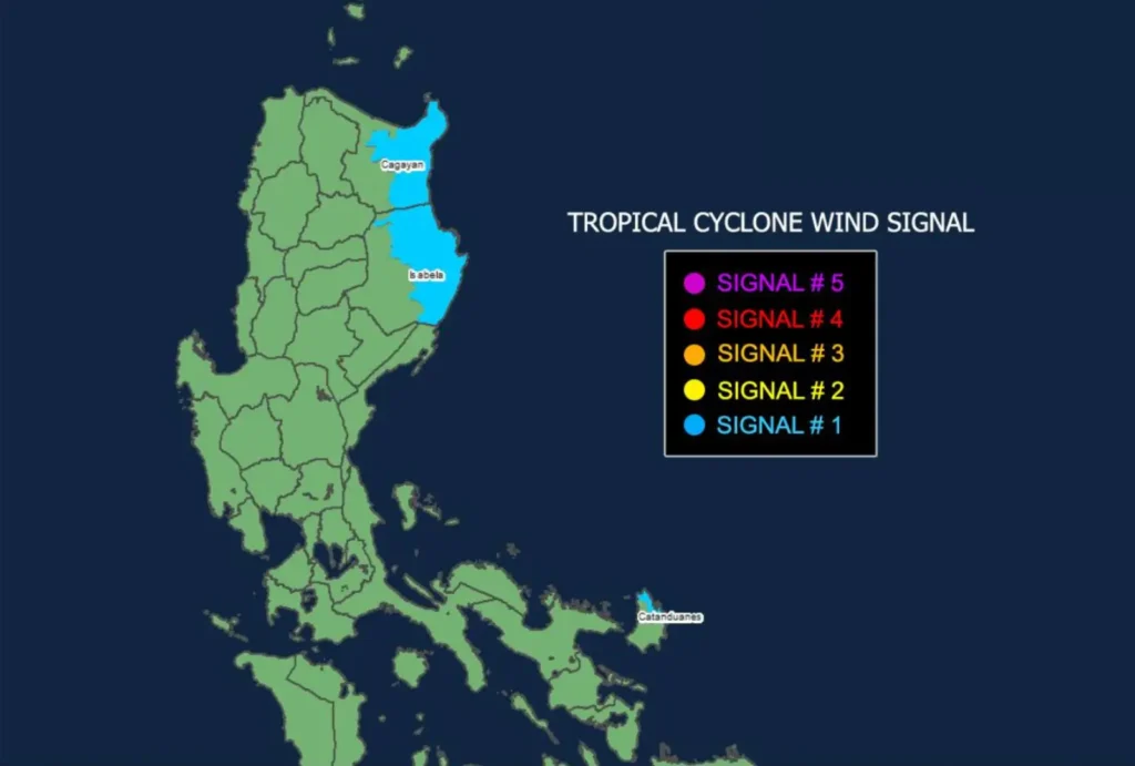
This wind signal warns of strong winds reaching 39-61 km/h, which may cause minimal to minor impacts on life and property.
Rainfall and Severe Winds Warning
While Leon’s outer rainbands may impact Extreme Northern Luzon in the coming days, its trough could bring rain to Visayas, Mindanao, and the western parts of Southern Luzon.
Residents in these areas are advised to monitor updates, as a Weather Advisory may be issued.
Areas currently under Wind Signal No. 1 may experience gusty conditions, particularly in coastal and upland regions.
Winds may be slightly enhanced in areas more exposed to Leon’s circulation, with gusty conditions expected to impact parts of Palawan, Romblon, Catanduanes, Sorsogon, Masbate, and most of Visayas, Dinagat Islands, Surigao del Norte, and Camiguin throughout today.
On Monday, the gusty winds may reach Batanes, Babuyan Islands, Batangas, much of MIMAROPA, Bicol Region, Visayas, Northern Mindanao, and Caraga. Tuesday’s gusty conditions are forecast for Aurora, Metro Manila, CALABARZON, MIMAROPA, Bicol Region, Visayas, Dinagat Islands, Surigao del Norte, and Camiguin.
Coastal Waters and Sea Conditions
PAGASA advises mariners of small seacrafts, including motorbancas, to avoid sea navigation in hazardous conditions.
Rough seas up to 4 meters high are expected along the Batanes seaboard, while the Kalayaan Islands, Babuyan Islands, northern Cagayan Valley, and Catanduanes may experience waves up to 3 meters.
In other areas, moderate seas with waves reaching 2.5 meters are anticipated along Palawan, Batangas, Bataan, and Zambales, as well as around Occidental Mindoro, Pangasinan, La Union, Ilocos, Aurora, Quezon, and Northern Samar.
The eastern seaboard of Dinagat Islands may also experience waves up to 2 meters.
Forecast Track and Intensification
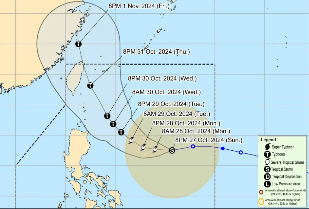
Leon is projected to intensify gradually over the next 24 hours, potentially reaching severe tropical storm status by Monday and typhoon intensity by Tuesday.
While the storm is expected to stay far from Philippine landmass, a westward shift in its track could bring it closer to Extreme Northern Luzon by midweek as it approaches Taiwan or the Ryukyu Islands.
Residents in affected areas are encouraged to stay informed through official PAGASA updates, especially as Leon intensifies and shifts in its course.