
Tropical Storm Leon slightly intensified this afternoon as it continues to move westward across the Philippine Sea. The storm, centered approximately 1,000 kilometers east of Central Luzon, now has maximum sustained winds of 75 km/h and gusts reaching up to 90 km/h, with a central pressure of 992 hPa.
Leon is currently moving westward at a speed of 20 km/h, with strong to gale-force winds extending outward up to 560 kilometers from its center.
Although no Tropical Cyclone Wind Signals are currently in effect, authorities warn that signal levels may be hoisted in parts of Cagayan Valley and the northeastern Bicol Region by tonight or early tomorrow.
The outer rainbands of Leon could affect Extreme Northern Luzon in the coming days, depending on its proximity during a forecasted shift to a northwestward path.
This movement could also enhance the Southwesterly Windflow, which may impact Visayas, Mindanao, and parts of Southern Luzon, potentially prompting a weather advisory.
As the storm approaches, gusty conditions are expected in Palawan, Romblon, Catanduanes, Sorsogon, and Masbate, as well as most of Visayas, Dinagat Islands, Surigao del Norte, and Camiguin.
By Monday, Batanes, Babuyan Islands, and the rest of MIMAROPA, Bicol Region, Visayas, Northern Mindanao, and Caraga Region should brace for similar conditions.
Strong winds will also likely reach Aurora, Metro Manila, CALABARZON, MIMAROPA, Bicol Region, and Visayas by Tuesday.
Hazards to Coastal Waters
Rough sea conditions are expected in various coastal areas. Waves up to 4 meters high may affect the seaboard of Batanes, while the seaboards of the Kalayaan and Babuyan Islands, Cagayan Valley, and Catanduanes may see waves up to 3 meters.
Mariners of small boats, especially those in ill-equipped vessels, are advised to avoid these areas.
Elsewhere, moderate seas are expected with waves reaching 2.5 meters along the coastlines of Palawan, Batangas, Bataan, Zambales, Occidental Mindoro, Pangasinan, La Union, Ilocos, Aurora, Quezon, and Northern Samar.
Track and Intensity Outlook
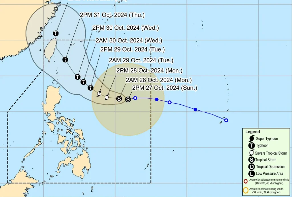
Tropical Storm Leon is forecast to gradually intensify over the next 24 hours, possibly reaching severe tropical storm status by Monday and typhoon strength by Tuesday.
The storm may pass near Taiwan or the southwestern portion of the Ryukyu Islands by midweek.
While Leon is expected to remain distant from the Philippine landmass, a slight westward shift in its track could bring the storm closer to Extreme Northern Luzon by Wednesday or Thursday.
Authorities urge residents, especially those in coastal and upland areas, to stay vigilant and heed updates from local weather agencies.