As of the 5:00 AM update from PAGASA, Tropical Depression Kristine has strengthened into a tropical storm and is now affecting parts of Luzon, Visayas, and Mindanao.
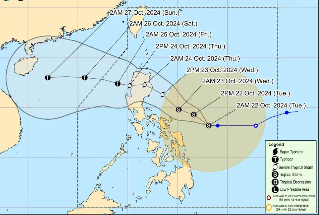
Located 390 km east of Virac, Catanduanes, the storm is packing maximum sustained winds of 65 km/h, with gusts reaching up to 80 km/h.
Kristine continues to move westward at 15 km/h, with strong to gale-force winds extending up to 680 km from its center.
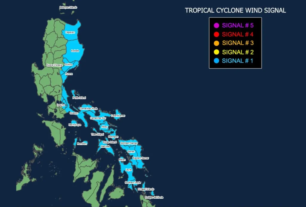
Areas Under Tropical Cyclone Wind Signal No. 1

Tropical Cyclone Wind Signal No. 1 is raised in the following areas:
Luzon: Portions of mainland Cagayan, Isabela, Quirino, Nueva Vizcaya (southern part), Aurora, parts of Rizal and Laguna, northern and eastern Quezon including Polillo Islands, Marinduque, Romblon, Camarines Norte, Camarines Sur, Catanduanes, Albay, Sorsogon, and Masbate including Ticao and Burias Islands.
Visayas: Eastern Samar, Northern Samar, Samar, Leyte, Biliran, and Southern Leyte.
Mindanao: Dinagat Islands and Surigao del Norte including Siargao and Bucas Grande Islands.
Potential Impacts
The areas under Signal No. 1 can expect strong winds between 39 to 61 km/h, posing minimal to minor threats to life and property.
Winds in coastal and upland areas may be enhanced, while those in sheltered locations will experience less intense conditions.
Residents are advised to monitor updates, as Kristine may intensify further. It is forecast to strengthen into a severe tropical storm tomorrow (October 23), with the potential to reach typhoon category by Friday (October 25) as it moves out of the Philippine Area of Responsibility (PAR) and into the West Philippine Sea.
Heavy Rainfall and Wind Outlook
Local advisories warn of heavy rainfall across affected regions, with the highest wind signal expected to be Signal No. 4 due to rapid intensification.
Gale-force winds are expected in Batanes, Babuyan Islands, Ilocos Region, parts of Palawan, and areas in Visayas and Mindanao.
Hazardous Sea Conditions
A Gale Warning has been issued for the eastern seaboards of Luzon and Visayas, with rough to very rough seas expected.
Sea conditions may reach up to 6.5 meters in some coastal areas, making sea travel extremely dangerous. Mariners are advised to remain in port and take necessary precautions until the storm subsides.
Track and Intensity Forecast

Tropical Storm Kristine is forecast to continue its west-northwest track and may make landfall over Isabela by tomorrow evening. The storm may further intensify as it progresses, with the possibility of reaching typhoon status by Friday.
The public is urged to stay updated on weather developments and heed warnings from local disaster management offices.
