
Typhoon Julian (#JulianPH) continues its course away from Batanes and is now heading towards the northwestern boundary of the Philippine Area of Responsibility (PAR), according to the latest update from PAGASA.
As of 4:00 PM today, the center of Typhoon Julian was located 95 km west-southwest of Itbayat, Batanes, with maximum sustained winds of 175 km/h near the center and gusts reaching 215 km/h.
The typhoon is moving west-northwestward at 15 km/h. Typhoon-force winds extend up to 560 km from the center, impacting areas within its reach.
Tropical Cyclone Wind Signals in Effect:
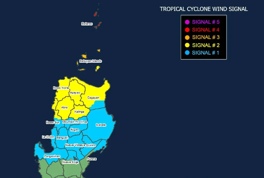
- Signal No. 4 (Typhoon-force winds): Batanes
- Winds between 118 to 184 km/h, posing a significant to severe threat to life and property.
- Signal No. 3 (Storm-force winds): Northern and western Babuyan Islands
- Winds ranging from 89 to 117 km/h, with moderate to significant risks.
- Signal No. 2 (Gale-force winds): Northern portions of Cagayan, Apayao, Abra, Kalinga, Ilocos Norte, and parts of Ilocos Sur.
- Winds between 62 to 88 km/h, with minor to moderate threats.
- Signal No. 1 (Strong winds): The rest of Cagayan, Ilocos Sur, La Union, Pangasinan, Ifugao, Benguet, and parts of Aurora and Nueva Ecija.
- Winds between 39 to 61 km/h, posing minimal to minor threats to life and property.
Rainfall and Storm Surge Risks
Heavy rains are expected over several regions, particularly in Batanes and Babuyan Islands, while a moderate to high risk of life-threatening storm surges persists over Batanes, Cagayan, and Ilocos Norte within the next 48 hours.
Sea Travel Advisory
A Gale Warning remains in effect over the seaboards of Northern Luzon.
Mariners, especially those in small seacrafts, are advised not to venture out to sea due to extremely rough waters, with waves reaching up to 14 meters in Batanes’ coastal areas. Sea travel is considered risky even for larger vessels.
Typhoon Track and Outlook
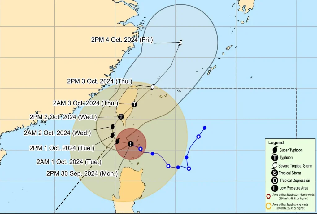
Typhoon Julian is expected to move slowly westward before recurving towards the northeastern direction by October 1.
It is forecast to make landfall on the southwestern coast of Taiwan on Wednesday, October 2. Although Julian may exit PAR briefly, updates will continue.
The typhoon is projected to reach super typhoon status by tonight, though its strength is expected to weaken as it interacts with Taiwan’s rugged terrain.
Authorities are urging the public and local disaster response teams to take the necessary precautions and adhere to evacuation orders.
Residents in flood-prone and landslide-prone areas are advised to monitor updates closely from local officials and PAGASA.