Typhoon Pepito (international name: Man-Yi) continues to gain strength as it approaches the Philippines, prompting authorities to issue higher Tropical Cyclone Wind Signals in various parts of the country.
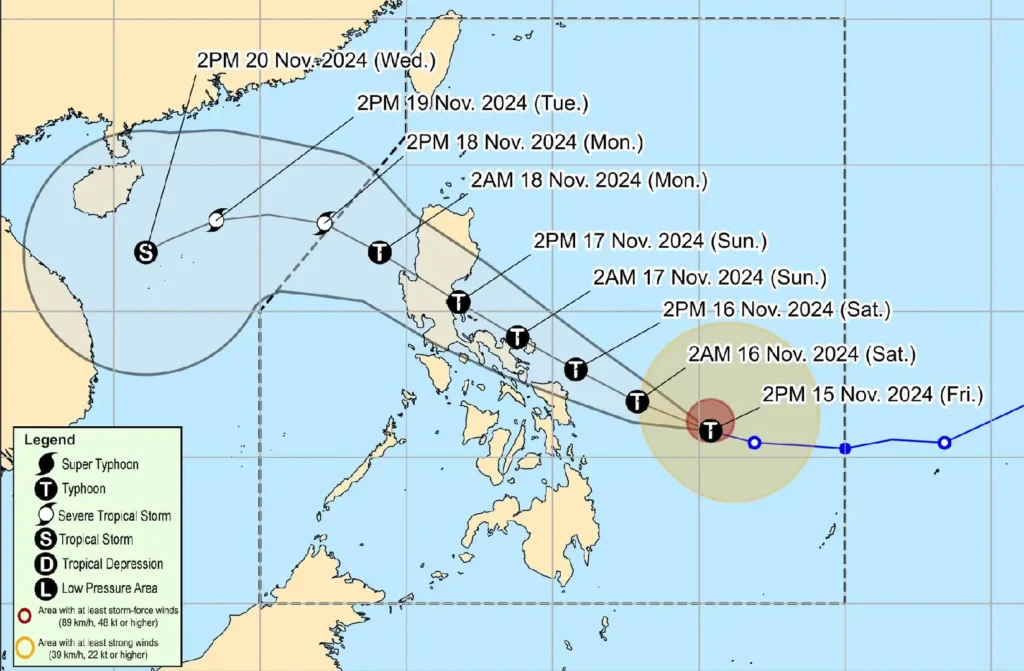
According to the Philippine Atmospheric, Geophysical and Astronomical Services Administration (PAGASA), Typhoon Pepito was last located 465 km east of Guiuan, Eastern Samar, as of 4:00 PM today.
The storm packs maximum sustained winds of 150 km/h near the center, with gusts reaching up to 185 km/h, and is moving west-northwest at a speed of 30 km/h.
Wind Signals Raised

More areas have now been placed under Tropical Cyclone Wind Signals as Typhoon Pepito intensifies:
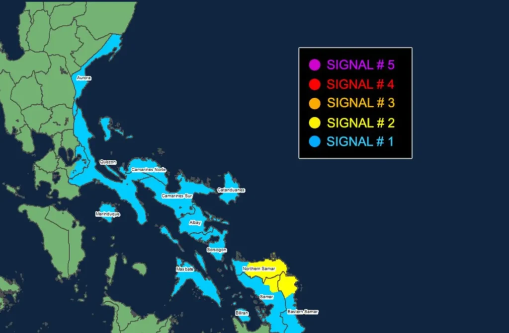
- Signal No. 2, with gale-force winds between 62 to 88 km/h, is in effect over parts of Northern Samar, Eastern Samar, and Samar in the Visayas, posing a minor to moderate threat to life and property.
- Signal No. 1 is raised over several areas in Luzon and the Visayas, including Aurora, Quezon, Laguna (eastern portion), Marinduque, Camarines Norte, Camarines Sur, Catanduanes, Albay, Sorsogon, Masbate, and Biliran. Residents in these areas should prepare for winds of 39 to 61 km/h.
Rainfall and Wind Threats
Heavy rains are expected to batter parts of the country, with potential flooding and landslides in vulnerable areas. PAGASA has issued a three-day heavy rainfall outlook and warns of possible minor to moderate impacts from strong winds.
Coastal areas should be on alert as life-threatening storm surges up to 3.0 meters high may occur over Aurora, Quezon, southeastern Batangas, northwestern Romblon, and the Bicol Region.
Sea Travel Advisory
PAGASA has issued Gale Warnings over the eastern seaboards of the Visayas, warning of high seas up to 8.0 meters in height.
Sea travel is extremely risky for all types of vessels, and mariners are advised to seek safe harbor until conditions improve.
Track and Intensity Forecast

Typhoon Pepito is projected to make landfall near Catanduanes tomorrow evening or early Sunday morning.
However, it may also strike the eastern coasts of Camarines Sur, Albay, Sorsogon, or Northern Samar within the same period.
The typhoon is expected to pass through Bicol, Quezon, Central Luzon, and Pangasinan over the weekend before emerging in the West Philippine Sea by Monday.
Rapid intensification is anticipated, and Pepito may become a super typhoon before landfall, though weakening is expected once it crosses Central Luzon.
