
15 November 2024, 5:00 AM — Typhoon Ofel (USAGI) is gradually weakening as it moves over the Luzon Strait.
As of 4:00 AM, the typhoon’s center was positioned 100 kilometers northwest of Calayan, Cagayan, carrying maximum sustained winds of 120 km/h and gusts of up to 150 km/h.
The storm is moving north-northwestward at 20 km/h, with strong to typhoon-force winds extending up to 340 kilometers from the center.
Tropical Cyclone Wind Signals in Effect

- Signal No. 3: Storm-force winds are expected in the western portion of the Babuyan Islands, the northwestern part of mainland Cagayan, and northernmost Ilocos Norte, with a moderate to significant threat to life and property.
- Signal No. 2: Gale-force winds threaten the rest of Babuyan Island, northwestern mainland Cagayan, northern Apayao, and northern Ilocos Norte, posing a minor to moderate threat.
- Signal No. 1: Strong winds will affect Batanes, the rest of Cagayan, northern Isabela, Apayao, Kalinga, parts of Abra, and the northern portions of Ilocos Norte and Ilocos Sur, with minimal to minor impacts anticipated.
Rainfall and Wind Hazards
Communities should brace for strong winds that may be enhanced in coastal and mountainous regions, leading to potential damage and disruptions.
The public is also advised of significant storm surges, with peak heights of up to 3.0 meters expected in low-lying coastal areas of Batanes, Cagayan, including Babuyan Islands, Ilocos Norte, Ilocos Sur, and Isabela.
Coastal Waters and Maritime Conditions
Very rough seas with waves up to 5.0 meters are expected around Batanes and Babuyan Islands, while northern seaboards of Ilocos Norte and Cagayan may experience waves up to 4.5 meters.
Sea travel is extremely dangerous for all vessel types, and mariners are urged to remain in port until conditions improve.
Small craft operators are strongly advised against venturing out.
Track and Forecast
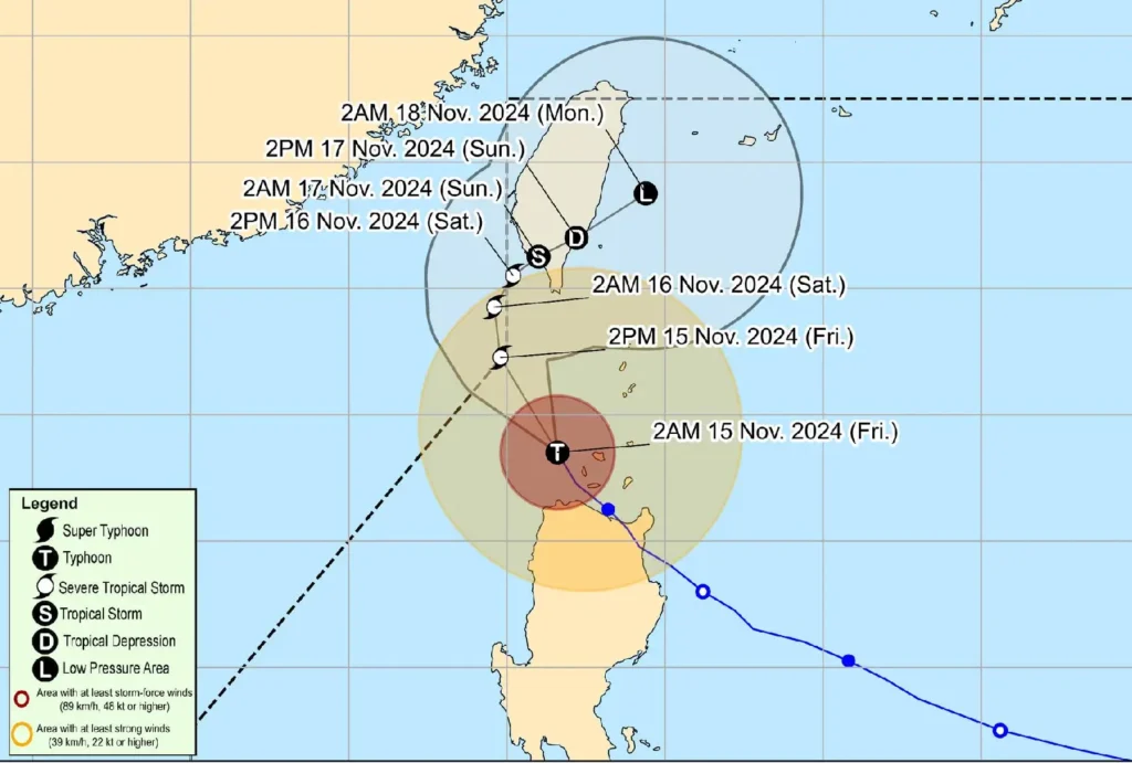
Typhoon Ofel will likely exit the northwestern boundary of the Philippine Area of Responsibility (PAR) this afternoon but may re-enter and linger near southern Taiwan as it shifts northeastward.
The system is expected to continue weakening due to unfavorable conditions in the Luzon Strait and may degenerate into a remnant low-pressure area as it moves toward the sea east of Taiwan.
Advisory
Residents in affected areas must remain vigilant and follow safety guidelines from local authorities. Prepare for the potential impacts of storm-force winds and dangerous coastal conditions. Mariners should exercise extreme caution and avoid sea travel under the current hazardous weather.