
Typhoon Ofel (Usagi) continues to intensify as it approaches Northern Luzon, prompting the Philippine Atmospheric, Geophysical, and Astronomical Services Administration (PAGASA) to expand Tropical Cyclone Wind Signal No. 2 to additional areas.
Current Position and Movement
As of 4:00 PM today, the eye of Typhoon Ofel was located 480 km east of Baler, Aurora, based on data from the Daet Weather Surveillance Radar.
It is moving west-northwest at 25 km/h, carrying maximum sustained winds of 120 km/h near the center and gusts reaching 150 km/h, with a central pressure of 975 hPa.
The storm’s winds extend outwards up to 320 km from the center.
Wind Signals in Effect
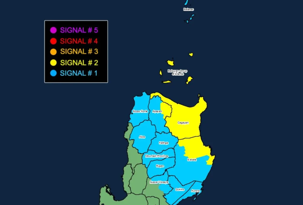
- TCWS No. 2: Cagayan including Babuyan Islands, northern and eastern Isabela, and eastern Apayao are under this signal, facing gale-force winds of 62 to 88 km/h. Expect minor to moderate damage to life and property.
- TCWS No. 1: Batanes, parts of Isabela, Quirino, northern Nueva Vizcaya, Apayao, Kalinga, Abra, Mountain Province, Ifugao, Ilocos Norte, and northern Aurora are under this signal, bracing for strong winds of 39 to 61 km/h. Possible impacts are minimal to minor.
Potential Hazards
- Heavy Rainfall: Rainfall warnings are in effect; refer to PAGASA’s latest advisories for detailed outlooks.
- Severe Winds: Areas under TCWS No. 2 may experience strong winds with minor to moderate impacts, while TCWS No. 1 areas face a minimal to minor threat.
- Storm Surge: There is a risk of life-threatening storm surge, potentially reaching 1.0 to 3.0 meters in the next 48 hours in low-lying coastal areas of Batanes, Ilocos Norte, Ilocos Sur, Cagayan, Isabela, and northern Aurora.
- Coastal Waters: Extremely rough seas up to 10 meters high are forecast over the eastern seaboard of mainland Cagayan and Babuyan Islands, making sea travel hazardous for all types of vessels.
Track and Intensity Forecast
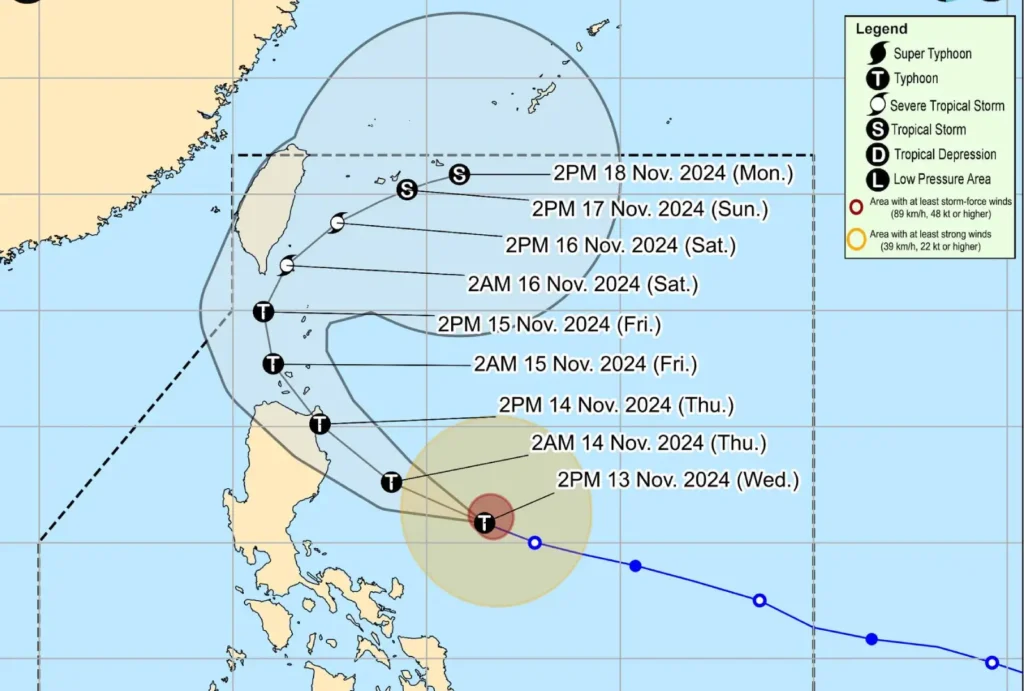
Typhoon Ofel is expected to make landfall along the eastern coast of Cagayan or Isabela tomorrow afternoon and will traverse the Luzon Strait on Friday, passing near or over Babuyan Islands.
It will likely turn northeastward on Saturday toward the sea east of Taiwan.
Ofel is expected to intensify further before landfall but will weaken as it interacts with land.
Residents and authorities in affected areas are urged to take precautions and follow evacuation orders where necessary. Continue to monitor PAGASA’s updates and warnings, and stay safe as the typhoon nears.