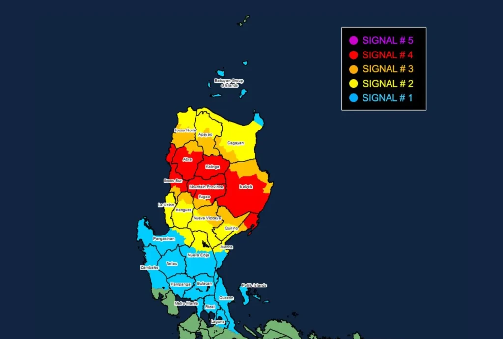
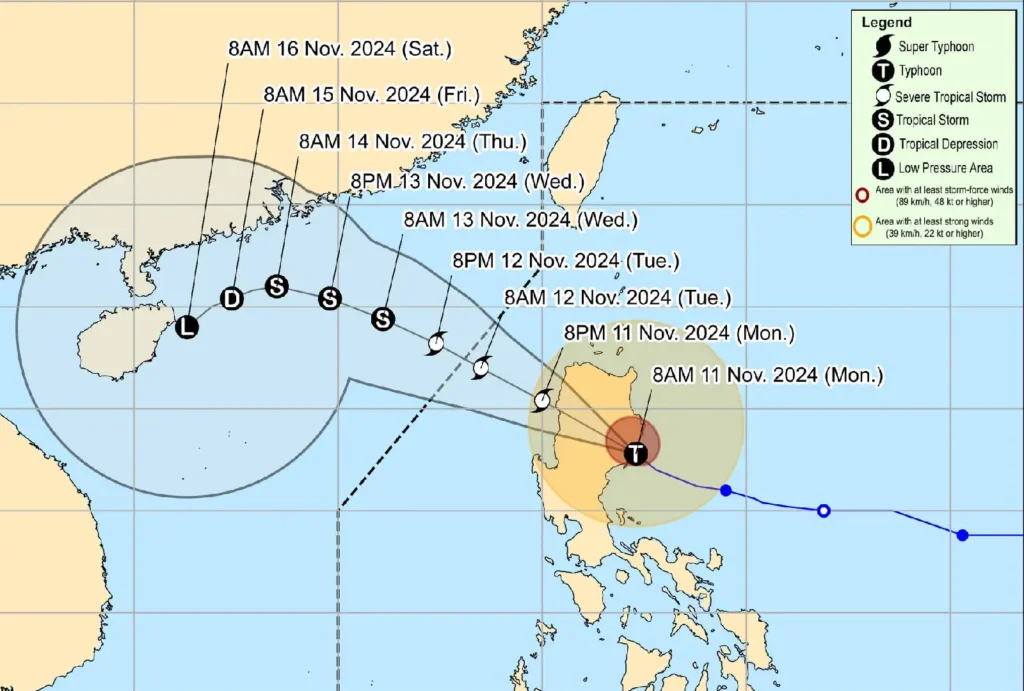
Typhoon Nika (international name: Toraji) has made landfall over Dilasag, Aurora, at around 10:00 AM today and is currently moving across northern Luzon.
The typhoon, packing destructive winds and intense rainfall, is expected to continue its path northwestward at 25 km/h. At 10:00 AM, the center of Nika was located near San Agustin, Isabela (16.5°N, 121.8°E).
Intensity and Movement
- Maximum sustained winds: 130 km/h near the center
- Gustiness: Up to 180 km/h
- Central pressure: 965 hPa
- Direction: Northwestward at 25 km/h
Wind Signals and Impact Forecast

- Tropical Cyclone Wind Signal No. 4
- Areas: Northern Aurora (Dilasag, Casiguran), central and southern Isabela, Kalinga, Mountain Province, northern Ifugao, parts of Abra, and Ilocos Sur.
- Wind Speeds: 118 to 184 km/h
- Potential Impact: Severe threat to life and property, with extensive damage expected.
- Tropical Cyclone Wind Signal No. 3
- Areas: Central Aurora, northern Quirino, parts of Nueva Vizcaya, southwestern Cagayan, southern Apayao, and the northern Benguet region.
- Wind Speeds: 89 to 117 km/h
- Potential Impact: Significant threat to life and property, with considerable damage likely.
- Tropical Cyclone Wind Signal No. 2
- Areas: Portions of Cagayan, the rest of Nueva Vizcaya, Apayao, and La Union, among others.
- Wind Speeds: 62 to 88 km/h
- Potential Impact: Moderate to minor damage; some disruption to daily activities is expected.
- Tropical Cyclone Wind Signal No. 1
- Areas: Metro Manila, the rest of Nueva Ecija, Zambales, Bulacan, Rizal, and parts of Laguna and Quezon.
- Wind Speeds: 39 to 61 km/h
- Potential Impact: Minimal to minor damage; strong winds may disrupt some services and outdoor activities.
Hazards and Warnings
- Heavy Rainfall: A weather advisory remains in effect for areas under Typhoon Nika’s influence, warning of potential flash floods and landslides.
- Severe Winds: Areas under Wind Signal No. 4 may experience devastating winds capable of uprooting trees and toppling weak structures. Signal No. 3 areas should prepare for strong gusts and possible infrastructural damage.
- Coastal Inundation: A moderate to high risk of storm surge threatens coastal areas, including Ilocos Norte, Cagayan, Zambales, and Quezon. Residents in vulnerable areas should be on high alert for potential flooding.
Sea Conditions and Gale Warnings
- Rough to Very Rough Seas: Waves reaching up to 8.0 meters are forecast along the seaboards of Isabela and Aurora, with hazardous conditions persisting around Northern Luzon. All sea travel is risky, and mariners are urged to remain in port.
- Moderate to Rough Seas: Conditions of up to 4.0 meters are expected in the eastern waters of Northern Samar and Kalayaan Islands. Mariners using small vessels should exercise extreme caution.
Track and Intensity Forecast

Typhoon Nika will continue its northwestward course, likely exiting the Philippine Area of Responsibility by tomorrow, November 12. Interaction with landmass will gradually weaken the typhoon, possibly downgrading it to a severe tropical storm. It is projected to further weaken and become a remnant low by November 15 as it approaches the southern coast of China.
Preparedness and Precaution
Authorities advise all residents in affected areas to remain vigilant, adhere to evacuation orders when necessary, and monitor updates from local government units and weather agencies.
