Typhoon Nika (international name: TORAJI) has intensified into a formidable typhoon as it churns over the waters east of Aurora province, bringing the threat of widespread destructive winds, torrential rainfall, and coastal flooding.
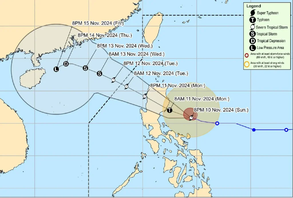
As of 4:00 AM today, the Philippine Atmospheric, Geophysical and Astronomical Services Administration (PAGASA) recorded the eye of Nika about 100 kilometers east-southeast of Casiguran, Aurora, based on Baler and Daet weather radars.
The storm is rapidly moving west-northwestward at 20 kilometers per hour.
Typhoon’s Strength and Reach
Nika now packs maximum sustained winds of 120 kilometers per hour near the center, with gusts reaching up to 150 kilometers per hour. Its central pressure stands at 970 hPa.
The typhoon’s wind field is extensive, with strong to typhoon-force winds radiating outward up to 340 kilometers from the center. This vast reach underscores the extensive impact areas even outside Nika’s direct path.
Areas Under Threat: Wind Signal Warnings

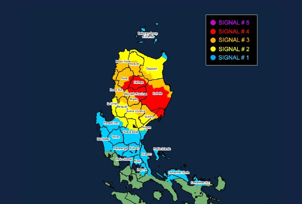
PAGASA has issued multiple Tropical Cyclone Wind Signals (TCWS) to highlight areas most vulnerable to the typhoon’s strength:
- TCWS No. 4 (Typhoon-force Winds: 118-184 km/h, 12-hour lead time): This severe warning covers the northernmost parts of Aurora, particularly Casiguran and Dilasag, along with vast areas in southern and central Isabela, southeastern Abra, and sections of Mountain Province, Ifugao, and Kalinga. Residents in these areas should prepare for life-threatening winds, significant structural damage, and major disruptions.
- TCWS No. 3 (Storm-force Winds: 89-117 km/h, 18-hour lead time): Areas include parts of Aurora, northern Nueva Vizcaya, northern Quirino, and the southwest of Cagayan, among others. Expect moderate to severe damage to property and possible power and communication outages.
- TCWS No. 2 (Gale-force Winds: 62-88 km/h, 24-hour lead time): Extending over central Aurora, northern and eastern Cagayan, and additional portions of the Ilocos region and Pangasinan, winds in these areas pose a moderate threat.
- TCWS No. 1 (Strong Winds: 39-61 km/h, 36-hour lead time): This signal covers Metro Manila, Bulacan, Pampanga, and parts of Zambales, as well as the Polillo Islands and northeastern Camarines Sur, among others. Although the threat here is minor, vigilance remains necessary.
Heavy Rainfall and Coastal Hazards
Severe Rainfall Outlook: Intense rainfall is expected, particularly in regions under higher wind signals. Communities in low-lying and mountainous areas should brace for potential flooding and landslides.
Coastal Inundation: PAGASA warns of moderate to high risks of storm surges, especially in vulnerable localities along the western seaboards of Luzon, including Ilocos Norte, Ilocos Sur, and Aurora.
Residents near coastlines should heed local authorities and evacuate if necessary.
Sea Travel Risks: Gale warnings are in effect over the eastern seaboard of Luzon and northern seaboards of Northern Luzon.
Sea travel remains perilous, with wave heights reaching up to 8 meters along the coasts of Isabela and Aurora. Mariners, particularly those operating small vessels, are advised to remain in port and take all precautions.
Path and Intensity Forecast

Typhoon Nika is expected to continue moving west-northwestward, making landfall over Isabela or northern Aurora later this morning.
After crossing Luzon, Nika will likely emerge over the West Philippine Sea tonight and could exit the Philippine Area of Responsibility by tomorrow.
However, the typhoon’s strength may weaken as it interacts with the rugged terrain of Luzon.
Potential Landfall Impacts: Even outside the core area, significant hazards like landslides, flash floods, and wind damage could occur. The public must remain vigilant, closely monitoring updates and advisories.
Precautions and Preparedness
Residents in affected areas, especially those under TCWS No. 3 and 4, should take urgent steps to protect life and property.
Prepare for possible evacuations, secure loose outdoor objects, and ensure emergency kits are readily available. Authorities are emphasizing the importance of staying informed and following the guidance of local disaster risk management offices.
