Typhoon Marce (international name: Yinxing) continues to batter Northern Luzon as it makes another landfall over Sanchez-Mira, Cagayan, causing severe weather conditions across the region.
The latest Tropical Cyclone Bulletin issued at 11:00 PM reports potentially life-threatening winds, storm surge, and torrential rainfall, prompting urgent warnings to the public in affected areas.
Typhoon Status and Location
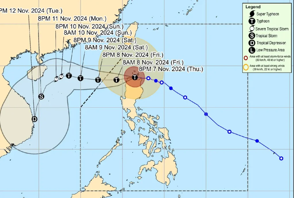
As of 10:00 PM, the eye of Typhoon Marce was located near Claveria, Cagayan (18.5°N, 121.1°E). It maintains its strength with maximum sustained winds of 175 km/h near the center and gustiness reaching up to 290 km/h.
The central pressure is recorded at 940 hPa. The typhoon is moving westward at 20 km/h, and its strong to typhoon-force winds extend up to 560 km from the center.
Tropical Cyclone Wind Signals (TCWS)

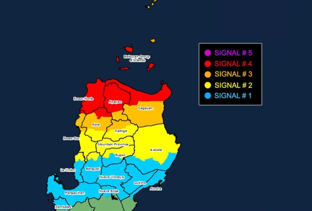
Several areas in Northern Luzon are under varying levels of wind threat:
TCWS No. 4
- Wind threat: Typhoon-force winds
- Warning lead time: 12 hours
- Wind speed range: 118 to 184 km/h (Beaufort 12)
- Areas affected: Northern Cagayan (including Babuyan Islands), northern Apayao, northernmost Abra, Ilocos Norte, and northernmost Ilocos Sur
- Potential impacts: Significant to severe threat to life and property
TCWS No. 3
- Wind threat: Storm-force winds
- Warning lead time: 18 hours
- Wind speed range: 89 to 117 km/h (Beaufort 10-11)
- Areas affected: Batanes, rest of Babuyan Islands, central and southern Cagayan, Apayao, northern Kalinga, most of Abra, and northern Ilocos Sur
- Potential impacts: Moderate to significant threat to life and property
TCWS No. 2
- Wind threat: Gale-force winds
- Warning lead time: 24 hours
- Wind speed range: 62 to 88 km/h (Beaufort 8-9)
- Areas affected: Central Isabela, rest of Kalinga, Mountain Province, northern Ifugao, northern Benguet, and portions of Ilocos Sur and La Union
- Potential impacts: Minor to moderate threat to life and property
TCWS No. 1
- Wind threat: Strong winds
- Warning lead time: 36 hours
- Wind speed range: 39 to 61 km/h (Beaufort 6-7)
- Areas affected: La Union, Pangasinan, Ifugao, Benguet, Nueva Vizcaya, Quirino, and portions of Aurora, Nueva Ecija, and Zambales
- Potential impacts: Minimal to minor threat to life and property
Hazards Affecting Land Areas
Heavy Rainfall Outlook
The typhoon will bring heavy rainfall, increasing the risk of flooding and landslides. The public is advised to refer to Weather Advisory No. 20 for specific rainfall information.
Severe Winds
Significant to severe impacts from typhoon-force winds are anticipated in areas under TCWS No. 4, especially in upland and coastal regions.
Moderate to significant impacts are expected in regions under TCWS No. 3, with minor to moderate impacts under TCWS No. 2.
Winds may be enhanced locally, particularly in exposed areas.
Storm Surge Warning
There is a high risk of storm surge inundation, with water levels potentially exceeding 3 meters. Coastal localities of Batanes, Cagayan, Babuyan Islands, Isabela, Ilocos Norte, Ilocos Sur, and La Union are at critical risk.
Residents in these areas are urged to evacuate to higher ground if necessary.
Coastal and Sea Conditions
A Gale Warning is in effect, with rough to very high seas expected:
- Up to 12 meters: Seaboard of Babuyan Islands, Ilocos Norte, and northern Cagayan
- Up to 7 meters: Remaining Cagayan seaboards, Batanes, and Ilocos Sur
- Up to 5 meters: Remaining Ilocos seaboards and northern Zambales, Isabela coastlines
Sea travel is deemed extremely dangerous, and all mariners are advised to remain in port or seek immediate shelter. Small sea vessels, in particular, should not venture out to sea.
Track and Intensity Forecast

Typhoon Marce is forecast to continue moving westward across Northern Luzon, emerging over the waters west of Ilocos Norte early on November 8.
The system is expected to exit the Philippine Area of Responsibility by November 8 afternoon or evening.
While a slight weakening is anticipated as the typhoon interacts with land and dry air from the northeast, it is projected to remain a powerful typhoon throughout its journey.
Authorities have not ruled out the possibility of Marce intensifying into a Super Typhoon.
Safety and Preparedness Measures
Residents in affected areas are advised to take all necessary precautions. Evacuate if instructed by local authorities, and remain updated on the latest weather advisories.
Keep emergency kits ready and stay indoors during the peak of the storm to minimize risk.
