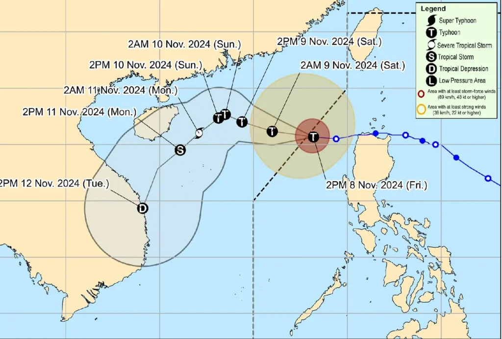
Typhoon “Marce” (international name: YINXING) has exited the Philippine Area of Responsibility (PAR), but precautionary measures remain in place for coastal and highland communities across Northern Luzon as hazardous winds and rough seas persist.
Typhoon Location and Intensity
At 10:00 AM today, the center of Typhoon Marce was tracked at 18.4°N, 117.8°E, situated over the West Philippine Sea. Marce continues to be a formidable system, sustaining maximum winds of 150 km/h near its eye, gusts reaching up to 185 km/h, and a central pressure of 960 hPa.
The typhoon is moving west southwestward at 20 km/h.
The storm’s winds extend up to 400 kilometers from its center, affecting wide areas with varying intensities, although all Tropical Cyclone Wind Signals have been lifted.
Severe Winds Still Impacting Land Areas
Despite Typhoon Marce’s departure from PAR, northeasterly wind flow and the storm’s outer bands will deliver strong to gale-force gusts over northernmost parts of Luzon.
Residents in Batanes, northern Cagayan (including the Babuyan Islands), and the Ilocos Region should brace for intense winds, particularly in exposed coastal and highland zones.
Localized damage to structures and vegetation, as well as difficulties in outdoor activities, are possible.
Coastal Inundation and Storm Surge
The previously issued storm surge warning has now been lifted, and no further coastal inundation is anticipated. The last storm surge advisory was released at 2:00 PM, signaling the end of the most immediate threat. Nonetheless, sea conditions remain treacherous in several areas.
Sea Condition Warnings
The Philippine Atmospheric, Geophysical, and Astronomical Services Administration (PAGASA) has issued Gale Warning No. 11, emphasizing very rough to rough seas that pose a significant risk to marine operations. Here’s what mariners and coastal communities need to know:
- Very Rough Seas (up to 4.5 m): This condition affects the western seaboards of Ilocos Norte and Ilocos Sur. Sea travel remains perilous for all vessels, with advisories for mariners to seek immediate shelter or remain docked.
- Rough Seas (up to 4.0 m): The coastal areas of Zambales, Batanes, Babuyan Islands, and the remaining western shores of the Ilocos Region are under this warning. Navigation here is discouraged.
- Moderate to Rough Seas (up to 3.5 m to 3.0 m): This warning applies to the northern coast of mainland Cagayan, the Babuyan Islands, and the seaboard of Isabela. Mariners of smaller boats are advised to take extra precautions or refrain from venturing out.
- Moderate Seas (up to 2.5 m to 2.0 m): This category extends to the seaboards of northern Aurora, Bataan, Lubang Islands, Calamian Islands, Palawan, and parts of Catanduanes, Polillo Islands, Northern Samar, and Dinagat Islands. Small motorbancas and lightly equipped vessels should exercise caution.
Typhoon Marce’s Track and Future Developments

The typhoon is expected to continue westward until tomorrow, 9 November, as it traverses the West Philippine Sea.
By Sunday, 10 November, the system will be influenced by a northeasterly surge, redirecting its movement west southwestward to southwestward.
PAGASA forecasts a re-intensification over the next 24 hours, but Marce will likely weaken afterward due to harsh atmospheric conditions from the incoming northeasterly wind flow.
