
Life-threatening weather conditions continue to grip northeastern Cagayan as Typhoon Marce made landfall over Santa Ana on Thursday afternoon.
The powerful storm, known internationally as Yinxing, was centered at 18.5°N, 122.0°E, packing maximum sustained winds of 175 km/h and gusts reaching up to 240 km/h, with a central pressure of 940 hPa.
Marce is moving westward at a pace of 10 km/h.
Severe Weather Warnings in Effect
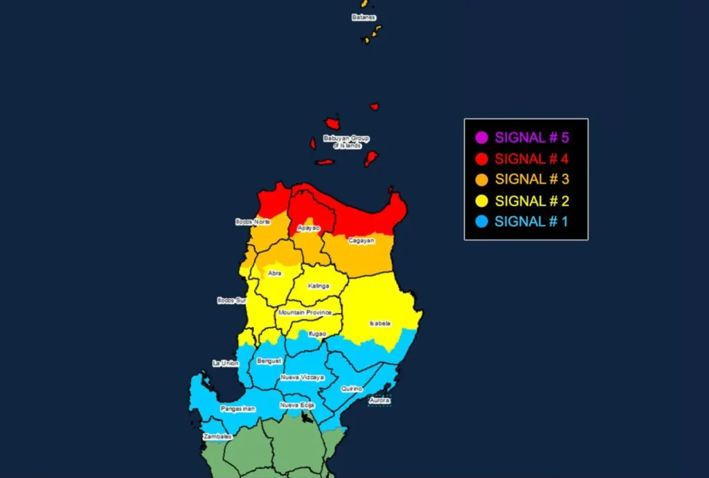
- Tropical Cyclone Wind Signal No. 4 has been raised over the northern portions of Cagayan, Apayao, and Ilocos Norte, where typhoon-force winds between 118 to 184 km/h are expected to pose a significant to severe threat to life and property. Areas under this signal, including the Babuyan Islands, are bracing for 12 hours of intense winds.
- Signal No. 3 is active over Batanes, the rest of Cagayan, Apayao, parts of Abra, and northern Ilocos provinces, with storm-force winds up to 117 km/h expected within 18 hours.
- Signal No. 2 covers sections of Isabela, Kalinga, Abra, and parts of Ilocos Sur, warning of gale-force winds within 24 hours, while Signal No. 1 spans broader areas, including La Union, Pangasinan, and parts of Aurora.
Heightened Risk of Storm Surges and Rough Seas
Residents in Batanes, Cagayan (including the Babuyan Islands), Ilocos Norte, Ilocos Sur, and La Union are on high alert for life-threatening storm surges, with peak heights projected to exceed 3.0 meters.
Mariners are advised to stay ashore, as sea conditions in Northern and Central Luzon’s seaboards range from rough to extremely rough, with waves reaching up to 12 meters in some areas.
Rainfall and Wind Impacts
Heavy rain and gale-force winds are forecast to persist, with local wind enhancements in coastal and upland regions. Severe impacts from typhoon-force winds are imminent under Signal No. 4 zones, while areas under lower wind signals will experience varying degrees of wind damage, ranging from minor to significant.
Path and Intensity Outlook
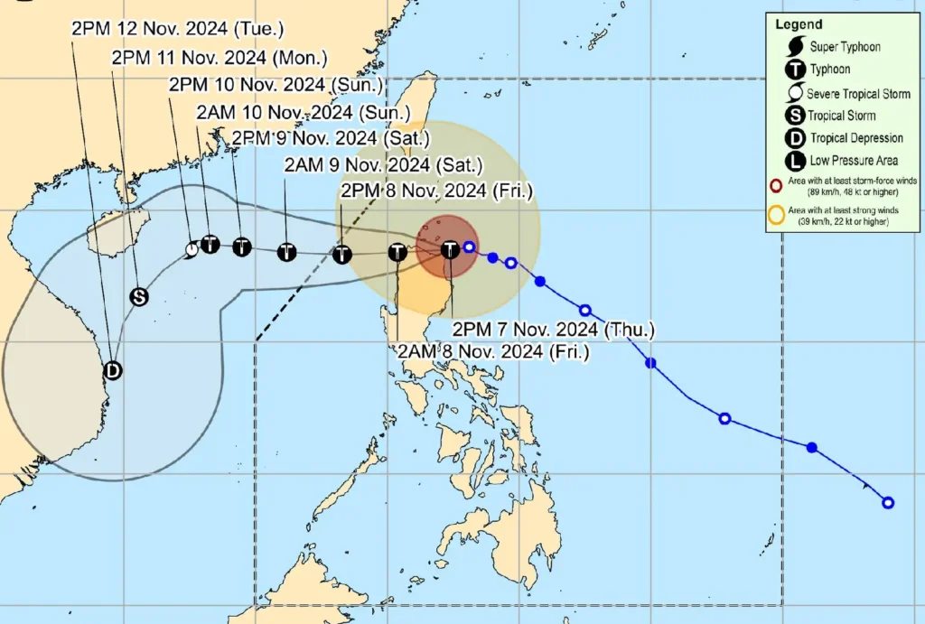
Typhoon Marce is expected to continue moving westward, possibly making another landfall in northwestern Cagayan tonight before emerging over Aparri Bay.
It will exit the Philippine Area of Responsibility (PAR) by Friday evening.
Although there is still a chance of the system intensifying into a super typhoon, interaction with Luzon’s mountainous terrain and prevailing dry air from the northeast are anticipated to weaken the storm gradually over the weekend.
Authorities are urging all residents in affected areas to take necessary precautions, remain indoors, and stay tuned to further weather advisories as Typhoon Marce continues to threaten Northern Luzon.