
Typhoon Leon, internationally known as Typhoon Kong-Rey, has intensified as it continues to approach Northern Luzon over the Philippine Sea.
The typhoon’s center was last located 450 km east of Aparri, Cagayan, with maximum sustained winds reaching 155 km/h and gusts of up to 190 km/h.
Movement and Wind Signals
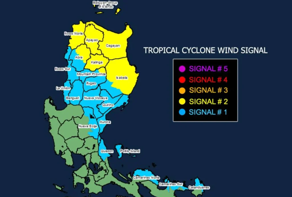
Leon is moving northwestward at a speed of 15 km/h. The Philippine Atmospheric, Geophysical, and Astronomical Services Administration (PAGASA) has issued Tropical Cyclone Wind Signal (TCWS) No. 2 over several areas due to expected gale-force winds.
This signal affects Batanes, Cagayan (including Babuyan Islands), parts of Isabela, Apayao, Kalinga, and areas in Ilocos Norte and Mountain Province.
These regions may experience winds of 62 to 88 km/h within the next 24 hours, potentially causing minor to moderate impacts.
TCWS No. 1 is also in place for parts of Luzon, including Quirino, Nueva Vizcaya, portions of Nueva Ecija, and regions in Camarines Norte, Camarines Sur, and Catanduanes, where winds may range from 39 to 61 km/h with minimal to minor impacts on life and property.
Severe Winds and Heavy Rainfall
PAGASA warns of severe winds, especially in coastal and mountainous areas, with winds becoming slightly stronger.
The highest wind signals, up to TCWS No. 5, may be issued if Leon continues to intensify as it moves closer to Batanes and Babuyan Islands.
Meanwhile, gusty conditions are expected outside wind-signal areas, affecting Metro Manila, CALABARZON, and the Bicol Region, among others.
Storm Surge and Sea Conditions
There is a high risk of life-threatening storm surges in low-lying coastal areas of Batanes and Cagayan, with water levels possibly reaching 2.0 to 3.0 meters above normal tide levels within 48 hours.
Gale warnings remain in effect over Northern Luzon’s seaboards and parts of Central and Southern Luzon, where very rough seas, up to 10 meters high, make sea travel risky for all types of vessels.
Track and Landfall Forecast
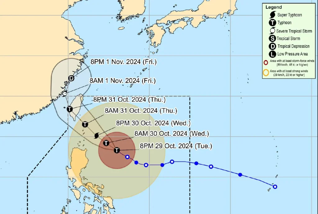
Leon is expected to make landfall along Taiwan’s eastern coast on Thursday, 31 October, before turning towards the East China Sea.
It is projected to reach or near super typhoon intensity by the time it nears Batanes on Thursday morning.
A landfall in Batanes cannot be ruled out, and PAGASA urges residents to monitor updates closely as Leon’s trajectory and intensity could still shift.