Typhoon Julian (international name: Krathon) is currently passing near Sabtang Island, Batanes, bringing typhoon-force winds and threatening severe damage to life and property in the northernmost part of the Philippines.
As of 10:00 AM, the eye of Typhoon Julian was spotted over the coastal waters of Sabtang Island, Batanes, with maximum sustained winds of 175 km/h near the center, gusting up to 240 km/h.
The typhoon is moving north-northwest at 10 km/h, with strong winds extending outward up to 580 km from the center.
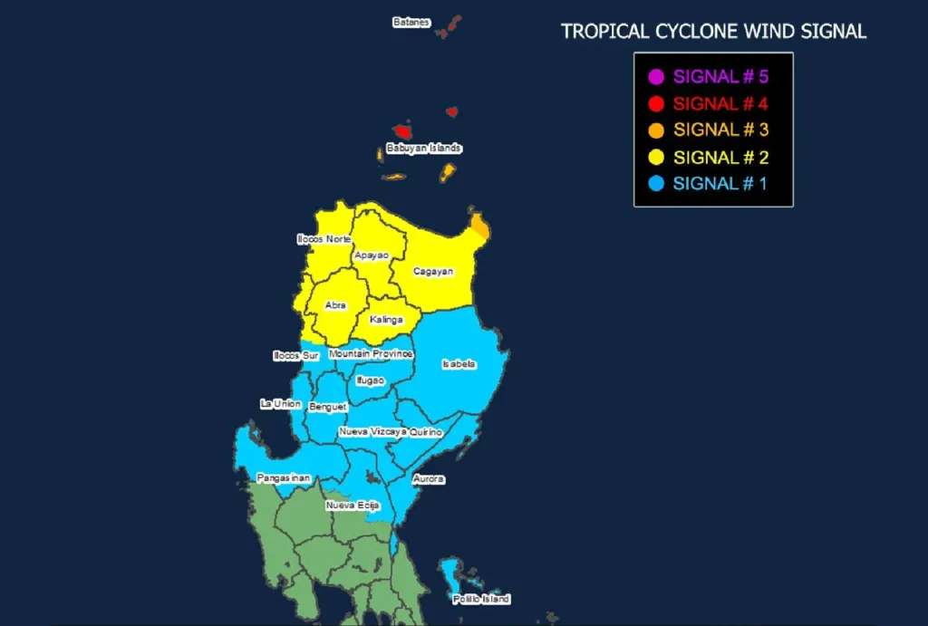
Tropical Cyclone Wind Signals in Effect

Several areas in Northern Luzon are under various Tropical Cyclone Wind Signals (TCWS) as Julian intensifies:
- TCWS No. 4: Batanes and the northern part of Babuyan Islands are bracing for typhoon-force winds with speeds ranging from 118 to 184 km/h. This poses significant to severe threats to life and property, with devastating winds expected this morning and into the afternoon.
- TCWS No. 3: The rest of the Babuyan Islands and northeastern Cagayan (Santa Ana) are expecting storm-force winds with speeds of 89 to 117 km/h, posing a moderate to significant threat to life and property.
- TCWS No. 2: Gale-force winds will be felt in Cagayan, Apayao, Abra, Kalinga, Ilocos Norte, and parts of Ilocos Sur, with wind speeds between 62 to 88 km/h.
- TCWS No. 1: Areas under this signal, including parts of Isabela, Nueva Vizcaya, Quirino, Aurora, and Polillo Islands, will experience winds between 39 to 61 km/h, posing minimal to minor threats to life and property.
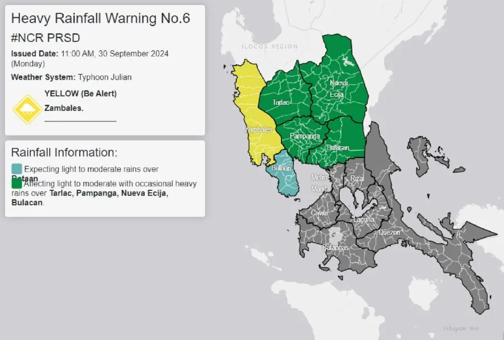
Heavy Rainfall and Strong Winds Expected

Typhoon Julian is expected to bring severe winds and heavy rainfall across affected areas. Residents in low-lying and coastal regions of Batanes, Cagayan, and Ilocos Norte are warned of the potential for storm surges in the next 48 hours, increasing the risk to life and property.
Additionally, areas like Metro Manila, CALABARZON, Bicol Region, and portions of Central Luzon are advised to prepare for strong to gale-force gusts today and tomorrow, as the typhoon’s circulation enhances local wind speeds.
Coastal Hazards and Sea Travel Warning
A gale warning has been issued for Northern Luzon’s seaboards, with waves reaching up to 14 meters around Batanes and up to 10 meters around the Babuyan Islands.
Mariners are advised to avoid sea travel, as conditions remain extremely dangerous for all types of vessels.
Sea conditions in areas along the northern coast of Ilocos Norte, Cagayan, and Ilocos Sur will also remain very rough, with waves reaching up to 6 meters.
All small seacrafts are urged to stay in port and seek shelter until conditions improve.
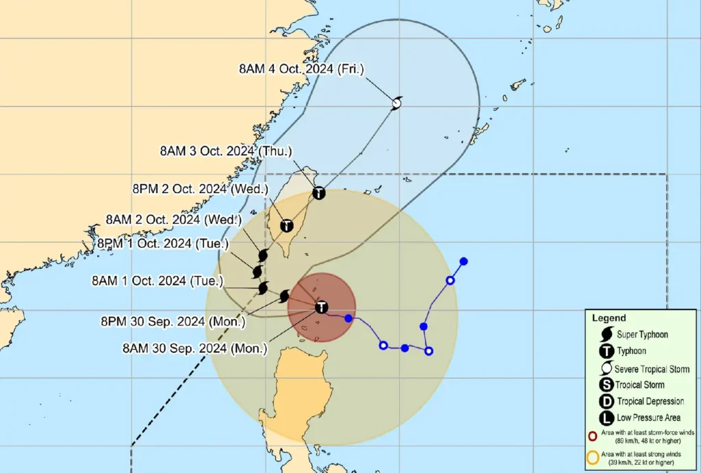
Track and Forecast

Typhoon Julian is expected to continue moving west-northwest through the Bashi Channel today before slowing and making a turn toward the north-northeast by Wednesday.
It is forecast to make landfall on the southwestern coast of Taiwan on October 2 before exiting the Philippine Area of Responsibility (PAR) by Thursday morning.
As Julian moves closer to Taiwan, there is a possibility of further intensification, with forecasts suggesting it may reach super typhoon status by this afternoon or evening.
However, interaction with Taiwan’s rugged terrain is expected to weaken the storm before it crosses the island.
Public Advisory
Residents in affected areas are urged to take all necessary precautions and follow the directives of local disaster risk reduction offices.
Evacuations may be necessary in flood-prone and coastal areas, and continued monitoring of local weather updates is strongly advised.
For real-time information on heavy rainfall, flooding, and evacuation alerts, follow updates from PAGASA and local authorities.
