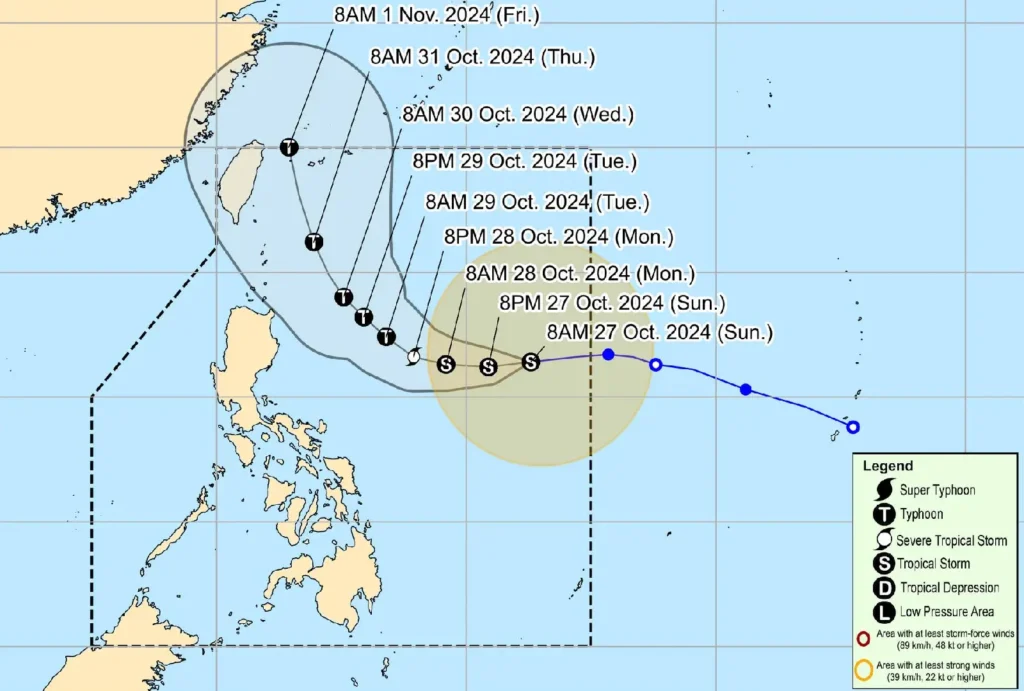
Tropical Storm Leon (Kong-Rey) is maintaining strength as it moves westward across the Philippine Sea, possibly impacting parts of Northern Luzon with gusty winds and heavy rains in the coming days, according to the latest advisory from PAGASA.
Tropical Storm Leon Status
- Location: As of 10:00 AM, the center of Leon was located about 1,075 km east of Central Luzon, positioned at 16.6°N, 132.2°E.
- Intensity: The storm holds maximum sustained winds of 65 km/h near its center, with gusts up to 80 km/h and a central pressure of 994 hPa.
- Movement: The storm is moving westward at 30 km/h.
- Wind Extent: Strong to gale-force winds extend up to 560 km from the center.
Rain and Wind Impacts Expected
While no Tropical Cyclone Wind Signals (TCWS) are currently hoisted, PAGASA warns that Signal No. 1 may be raised over Cagayan Valley and northeastern Bicol by tonight or early tomorrow. Depending on Leon’s path, Signal No. 2 could be issued in certain areas later.
- Rainfall: Outer rainbands may bring rains over Extreme Northern Luzon, while the Southwesterly Windflow, influenced by Tropical Storm Trami, may affect the Visayas, Mindanao, and parts of Southern Luzon.
- Gusty Winds: The storm is expected to cause strong to gale-force winds, especially in coastal and upland areas, affecting:
- Today, October 27: Palawan, Romblon, Catanduanes, Sorsogon, Masbate, most of the Visayas, Dinagat Islands, Surigao del Norte, and Camiguin.
- Tomorrow, October 28: Batanes, Babuyan Islands, Batangas, MIMAROPA, Bicol Region, Visayas, Northern Mindanao, and Caraga Region.
- Tuesday, October 29: Aurora, Metro Manila, CALABARZON, MIMAROPA, Bicol Region, Visayas, Dinagat Islands, Surigao del Norte, and Camiguin.
Coastal Waters Advisory
The storm is expected to create moderate to rough seas, with waves reaching:
- Up to 3.0 meters along the western seaboard of Luzon.
- Up to 2.5 meters along the northern and eastern seaboards of Northern Luzon, northern and eastern seaboards of Catanduanes, and northeastern parts of Northern and Eastern Samar.
Mariners, particularly operators of small vessels, are urged to exercise caution or avoid sailing under these conditions.
Forecast Track and Intensification

Leon is expected to continue moving westward today, transitioning to a northwestward path by tomorrow.
By Wednesday, October 30, it will shift to a north-northwestward track, with a forecasted close approach to or landfall in Japan’s Ryukyu Islands by Thursday.
The storm is expected to intensify over the next 24 hours, potentially reaching severe tropical storm status by tomorrow and typhoon strength by Tuesday, with the possibility of rapid intensification.
PAGASA advises the public to stay informed on local weather advisories, take necessary precautions, and prepare for potential gusty conditions in affected areas.
For more detailed updates and localized advisories, follow announcements from the PAGASA Regional Services Division.
