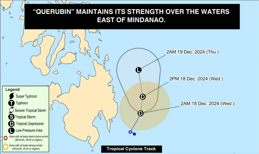
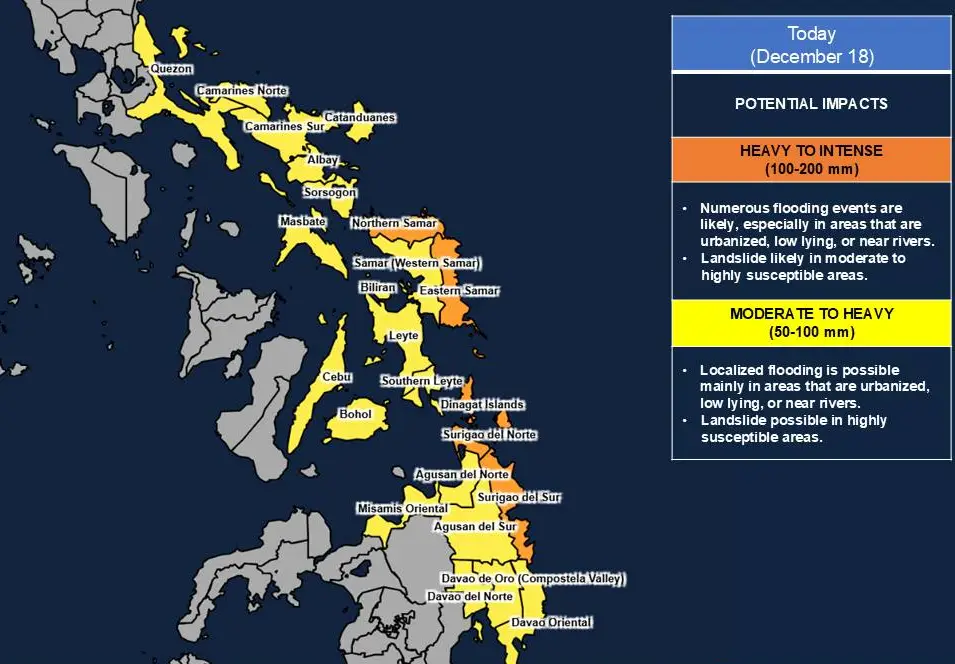
Tropical Depression ‘Querubin’ continues to maintain its strength while moving north-northwestward at a speed of 10 km/h over the waters east of Mindanao. The tropical depression is expected to weaken into a remnant low-pressure area within the next 24 hours but remains a cause for concern as it interacts with the Shear Line, potentially bringing heavy rainfall across parts of Visayas and Mindanao.
Current Location and Movement
- As of 5:00 AM, the center of Tropical Depression ‘Querubin’ was estimated at 230 km East of Davao City or 205 km East of Tagum City, Davao del Norte (07.5°N, 127.7°E).
- Moving north-northwestward at 10 km/h.
- Maximum sustained winds: 45 km/h near the center.
- Gustiness: Up to 55 km/h.
Track and Forecast

Over the next 24 hours, ‘Querubin’ is forecast to continue its northward movement over the waters east of Mindanao. By Thursday (December 19), it is expected to weaken into a remnant low-pressure area but may redevelop into a tropical depression upon reaching the West Philippine Sea.
- Forecast Positions:
- December 18, 2:00 PM: 165 km East Southeast of Hinatuan, Surigao del Sur
- December 19, 2:00 AM: 240 km East Southeast of Surigao City, Surigao del Norte
Heavy Rainfall Outlook

The combined effects of the Shear Line and Tropical Depression ‘Querubin’ are expected to bring moderate to heavy, and at times intense, rainfall across Visayas and Mindanao, even in areas far from the center of the tropical depression.
Residents in flood- and landslide-prone areas are advised to remain vigilant and follow local advisories. Refer to Weather Advisory No. 8 issued at 5:00 AM for detailed rainfall forecasts.
Wind Hazards
- Areas under Tropical Cyclone Wind Signal (TCWS) No. 1 are warned of winds ranging from 39-61 km/h within the next 36 hours.
- Affected Areas: Davao Oriental and nearby localities in Mindanao.
- Possible Impacts:
- Very light to light damage to structures made of light materials.
- Minor damage to crops such as banana plants and rice during its flowering stage.
- Broken twigs and slight tree damage may occur in exposed areas.
The highest wind signal expected during ‘Querubin’s occurrence is Signal No. 1.
Hazards for Coastal Waters
Rough to very rough sea conditions are expected across several coastal waters, making sea travel risky, particularly for small vessels and motorbancas. Mariners are strongly advised to remain in port or seek safe harbor until conditions improve.
- Up to 4.5 m: Seaboard of Batanes.
- Up to 4.0 m: Northern and eastern seaboards of Polillo Islands, Catanduanes, and Camarines Norte.
- Up to 3.5 m: Eastern seaboards of Cagayan, Aurora, Northern Samar, and parts of the Bicol Region.
- Up to 2.5 m: Eastern seaboard of Davao Oriental, Surigao del Sur, and Camotes Islands.
Safety Reminders
- Residents in affected areas should prepare for possible flooding and landslides. Monitor updates from PAGASA and local authorities.
- Mariners and fisherfolk are advised to avoid sea travel due to rough to very rough sea conditions.
