
The Low Pressure Area (LPA) east of Batanes has developed into Tropical Depression “Julian,” according to the Philippine Atmospheric, Geophysical, and Astronomical Services Administration (PAGASA).
Location and Intensity:
- As of 4:00 AM today, Tropical Depression Julian was spotted approximately 525 km East of Itbayat, Batanes (20.9°N, 126.9°E).
- It carries maximum sustained winds of 55 km/h, with gusts reaching up to 70 km/h and a central pressure of 1004 hPa.
- Julian is moving south-southwestward at 15 km/h with strong winds extending outward up to 150 km from the center.
Current Tropical Cyclone Wind Signal (TCWS):
No Wind Signal has been raised yet. However, Tropical Cyclone Wind Signal No. 1 may be issued over portions of Cagayan Valley later today. The highest signal that could be raised during the cyclone’s progress is Wind Signal No. 2 or 3.
Weather Hazards and Outlook:
- Heavy Rainfall: For the latest heavy rainfall outlook, refer to Weather Advisory No. 1, issued earlier today.
- Severe Winds: Strong to gale-force winds are expected over the following areas:
- Tomorrow (September 28): Aurora, Quezon, Bicol Region
- Sunday (September 29): Aurora, Bataan, Pampanga, Bulacan, Metro Manila, CALABARZON, Romblon, Marinduque, Bicol Region, Western Visayas, Negros Occidental, and Northern Samar.
Coastal Waters: Moderate seas are expected with wave heights reaching up to 2.5 meters along the seaboards of Batanes, Cagayan, and Isabela. Mariners of small vessels are advised to avoid sailing under these conditions or take necessary precautions.
Track and Intensity Forecast:
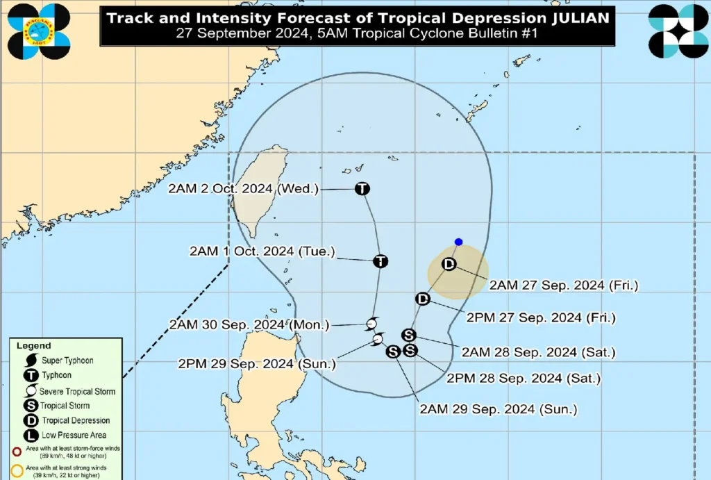
- Julian is projected to follow a looping path over the waters east of Batanes and Cagayan in the next five days.
- Today (September 27): It will move south-southwestward, decelerating as it progresses.
- Tomorrow (September 28): The cyclone will shift westward and begin intensifying.
- Sunday (September 29): Julian is forecast to move northwestward, with continued strengthening into a tropical storm.
- Monday-Tuesday (September 30-October 1): Further intensification into a severe tropical storm and eventually a typhoon by early next week.
Residents and local disaster management offices in affected areas are urged to take the necessary safety precautions. Those in high-risk zones should follow evacuation and safety instructions from their local officials. For localized updates, continue monitoring PAGASA’s bulletins and advisories.