
PAGASA has issued an urgent warning as Super Typhoon Pepito barrels toward Luzon, threatening catastrophic conditions across the affected areas.
As of 7:00 PM, the eye of the storm was located over the coastal waters of Gigmoto, Catanduanes, with maximum sustained winds of 195 km/h, gusts of up to 240 km/h, and a central pressure of 920 hPa.
Pepito is moving northwest at 20 km/h, with typhoon-force winds extending up to 300 km from the center.
Areas Under Wind Signals
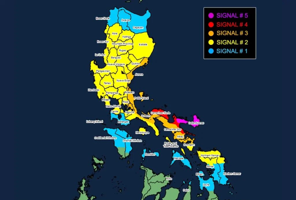
Tropical Cyclone Wind Signal No. 5
Typhoon-force winds expected within 12 hours (185 km/h or higher)
- Luzon: Catanduanes, Northeastern Camarines Sur (Caramoan, Garchitorena, Lagonoy, Presentacion)
Tropical Cyclone Wind Signal No. 4
Typhoon-force winds expected within 12 hours (118-184 km/h)
- Luzon: Camarines Norte, Northern and Southeastern Camarines Sur (Siruma, Tinambac, Goa, San Jose, Tigaon, Sagñay, Calabanga), Northeastern Albay (Tabaco City, Tiwi, Malinao, Malilipot, Bacacay, Rapu-Rapu)
Tropical Cyclone Wind Signal No. 3
Storm-force winds expected within 18 hours (89-117 km/h)
- Luzon: Aurora, Polillo Islands, Northern and Eastern Quezon (Calauag, Guinayangan, Tagkawayan, Buenavista, Lopez, Quezon, Perez, Alabat, Gumaca, Plaridel, Atimonan, Real, General Nakar, Infanta, Mauban, Sampaloc), Eastern Rizal (Tanay, Pililla), Northeastern Laguna (Santa Maria, Famy, Mabitac, Pakil, Pangil, Siniloan, Paete, Kalayaan, Lumban, Cavinti), Rest of Camarines Sur, Rest of Albay, Northern Sorsogon (Prieto Diaz, Sorsogon City, Gubat, Barcelona, Castilla, Casiguran, Pilar, Donsol)
Tropical Cyclone Wind Signal No. 2
Gale-force winds expected within 24 hours (62-88 km/h)
- Luzon: Isabela, Quirino, Nueva Vizcaya, Abra, Kalinga, Mountain Province, Ifugao, Benguet, Ilocos Sur, La Union, Pangasinan, Nueva Ecija, Bulacan, Tarlac, Pampanga, Zambales, Bataan, Metro Manila, Rest of Rizal, Rest of Laguna, Cavite, Rest of Quezon, Marinduque, Burias Island, Ticao Island, Rest of Sorsogon
- Visayas: Northern Samar, Northern Samar (Matuguinao, Calbayog City, Santa Margarita, San Jorge, San Jose de Buan, Gandara), Northern Eastern Samar (Dolores, Maslog, Jipapad, Arteche, Oras, San Policarpo)
Tropical Cyclone Wind Signal No. 1
Strong winds expected within 36 hours (39-61 km/h)
- Luzon: Mainland Cagayan, Apayao, Ilocos Norte, Batangas, Northern Occidental Mindoro (Sablayan, Santa Cruz, Mamburao, Abra de Ilog, Paluan) including Lubang Islands, Northern Oriental Mindoro (Puerto Galera, San Teodoro, Naujan, Baco, Victoria, Socorro, Pinamalayan, Bansud, Gloria, Pola, Calapan City, Bongabong, Roxas, Mansalay), Romblon, Rest of Masbate
- Visayas: Rest of Eastern Samar, Rest of Samar, Biliran, Northern and Central Leyte (Tunga, Pastrana, San Miguel, Matag-Ob, Tolosa, Palo, Calubian, Leyte, Mayorga, Julita, Carigara, Babatngon, Dagami, Jaro, San Isidro, Santa Fe, Albuera, Villaba, La Paz, Palompon, Tabontabon, Tanauan, Merida, Ormoc City, Isabel, Dulag, Capoocan, Alangalang, Burauen, Tabango, Tacloban City, Kananga, Barugo), Northernmost Cebu (Daanbantayan, Medellin) including Bantayan Islands, Northernmost Iloilo (Carles)
Heavy Rainfall Outlook
PAGASA warns of torrential rainfall exceeding 200 mm in Catanduanes, Camarines Sur, and surrounding provinces, increasing the risk of landslides and flash floods.
Affected regions should prepare for preemptive evacuations as conditions worsen. Heavy rain will spread westward, impacting areas like Aurora, Quezon, and Metro Manila from tomorrow.
Coastal Waters and Sea Conditions
- Extreme Sea Conditions: Seas around northern Catanduanes could reach heights up to 14 meters. Coastal waters off Camarines Norte, Aurora, and Northern Samar are expected to reach up to 12 meters, making sea travel extremely hazardous.
- High Storm Surge Risk: Low-lying areas in Metro Manila, Central Luzon, CALABARZON, and Bicol Region face potential inundation as storm surges may exceed 3 meters.
Additional Hazards
Heavy rainfall and storm surges exceeding 3 meters are anticipated in coastal areas, particularly in the Ilocos Region, Isabela, Metro Manila, CALABARZON, and Bicol Region.
Sea travel is deemed extremely dangerous, and all mariners are urged to remain in port until conditions stabilize.
PAGASA reminds the public to prepare for life-threatening impacts, secure properties, and follow evacuation orders from local authorities. Stay tuned for further updates.