
Severe Tropical Storm Julian has intensified further as it moves closer to Northern Luzon, according to the latest bulletin from PAGASA issued at 5:00 AM today, September 29, 2024.
Julian was last located 305 kilometers east of Aparri, Cagayan, packing maximum sustained winds of 95 km/h near the center and gusts of up to 115 km/h.
The storm is currently moving west-northwest at 10 km/h, with strong winds extending up to 450 km from the center.
Wind Signals in Effect:
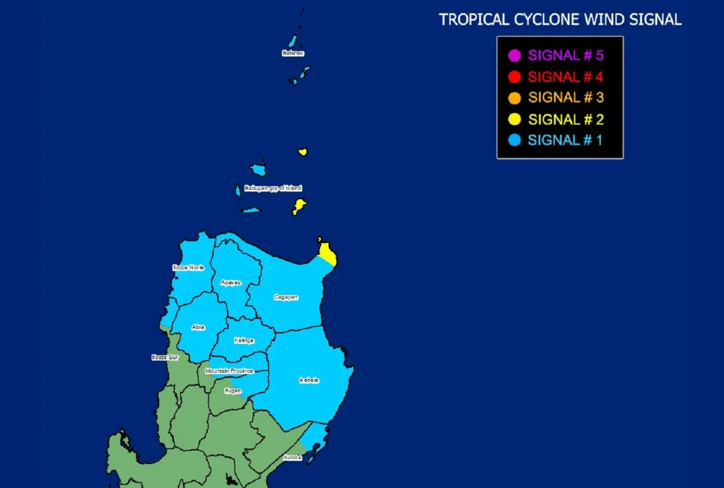
- Tropical Cyclone Wind Signal No. 2 is raised over the northeastern portion of Cagayan (Santa Ana) and the eastern portion of Babuyan Islands, warning of gale-force winds (62-88 km/h) within the next 24 hours. Minor to moderate impacts on life and property are expected.
- Tropical Cyclone Wind Signal No. 1 is hoisted over Batanes, the rest of Cagayan, parts of the Babuyan Islands, Isabela, Ilocos Norte, and portions of Ilocos Sur, Mountain Province, and Aurora. Winds of 39-61 km/h are expected within the next 36 hours, with minimal to minor impacts likely.
Rainfall and Wind Outlook:
- Heavy rainfall is expected in parts of Northern Luzon, especially in coastal and mountainous areas. Strong to gale-force winds will also affect Aurora, CALABARZON, Romblon, Bicol Region today, and areas like Pangasinan, Zambales, Bataan, and Quezon tomorrow.
- The possibility of Julian intensifying into a typhoon or even a super typhoon by tonight or tomorrow morning is high. A landfall or close approach over Batanes or the Babuyan Islands is highly likely by tomorrow, September 30.
Sea Conditions:
- A Gale Warning is in effect over the northern and eastern seaboards of Northern Luzon, with sea waves reaching up to 8.0 meters in Batanes and 6.0 meters in the Babuyan Islands. Sea travel is risky for all types of vessels, and mariners are advised to remain in port.
- Moderate to rough sea conditions are expected in the seaboards of Cagayan, Ilocos Norte, Isabela, and northern Aurora, with waves reaching up to 4.0 meters. Small boats and motorbancas are strongly advised against venturing out to sea.
Track and Intensification:
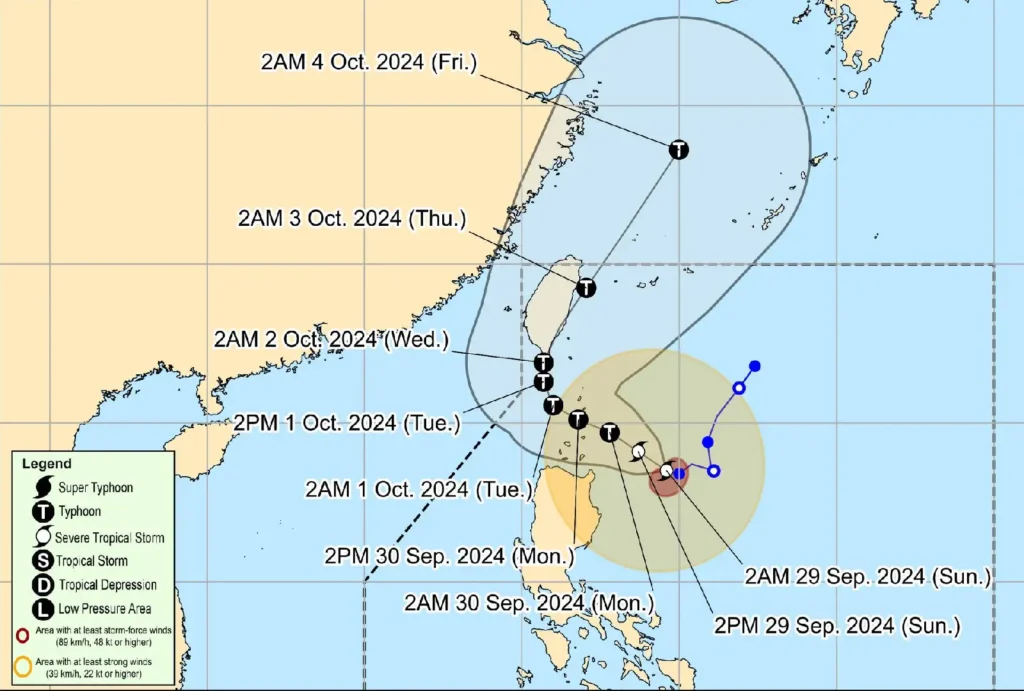
Julian is forecast to continue moving northwestward, nearing Batanes and the Babuyan Islands by tomorrow. It is expected to intensify into a typhoon by tonight or early tomorrow morning.
The storm may rapidly intensify, potentially reaching super typhoon status, posing significant risks to affected areas.
PAGASA advises the public to monitor further updates and take necessary precautions, especially in areas vulnerable to flooding, strong winds, and rough seas.