
As of 4:00 PM today, Tropical Storm Kristine has slightly intensified as it moves west-northwestward over the Philippine Sea, east of Bicol Region.
The center of Kristine is now located approximately 390 km east of Daet, Camarines Norte (14.3°N, 126.6°E).
Storm Intensity and Movement
Kristine now carries maximum sustained winds of 75 km/h near the center, with gustiness reaching up to 90 km/h and a central pressure of 990 hPa.
The storm is moving west-northwest at 15 km/h, with strong to gale-force winds extending up to 760 km from the center.
Wind Signal Alerts
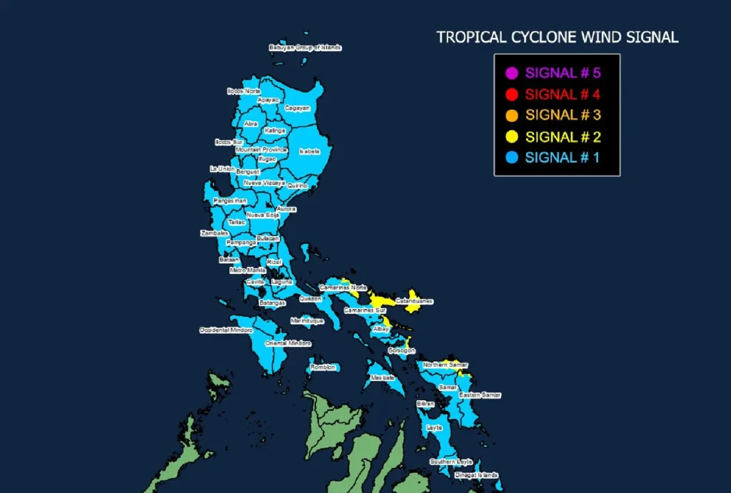
- Tropical Cyclone Wind Signal (TCWS) No. 2 is currently in effect over parts of Luzon (Catanduanes, eastern Camarines Norte, eastern Camarines Sur, eastern Albay, and eastern Sorsogon) and Visayas (northeastern Northern Samar and northern Eastern Samar).
- Winds of 62 to 88 km/h are expected, posing a minor to moderate threat to life and property.
- TCWS No. 1 covers various regions across Luzon, Visayas, and Mindanao, including Metro Manila, Cagayan Valley, Central Luzon, and parts of Northern Samar and Southern Leyte. Winds of 39 to 61 km/h are expected, posing minimal to minor threats.
Hazards Affecting Land Areas
Heavy rains and severe winds are expected to impact coastal and upland areas. A storm surge warning is in effect, with a risk of life-threatening coastal inundation in low-lying areas across Catanduanes, Camarines Norte, Camarines Sur, Albay, Quezon, Aurora, Isabela, and Cagayan. Localized heavy rainfall is also forecasted.
Coastal Waters and Sea Conditions
The storm is causing up to 7-meter waves along the seaboards of Batanes, Cagayan, Isabela, and parts of Bicol.
Gale warnings are in effect for the eastern and northern seaboards of Luzon and Visayas, making sea travel dangerous for all types of vessels.
Mariners are advised to remain in port or seek shelter until conditions improve.
Forecast Track and Intensity
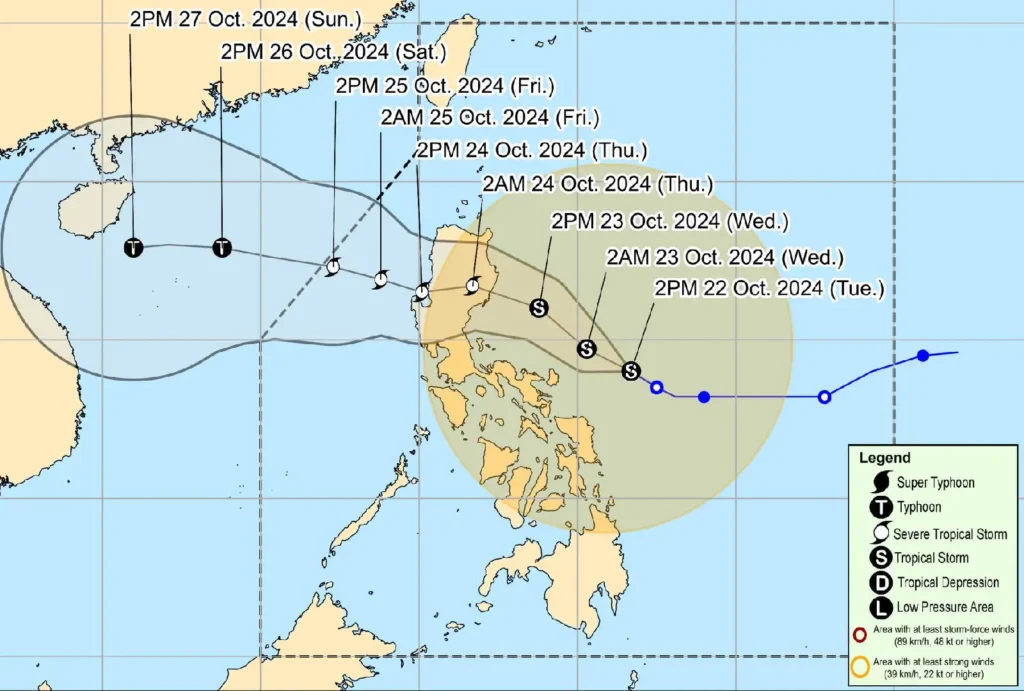
Tropical Storm Kristine is forecast to gradually intensify into a severe tropical storm before making landfall over Isabela or northern Aurora by tomorrow evening or early Thursday.
After crossing Northern Luzon, it may re-intensify into a typhoon over the West Philippine Sea before exiting the Philippine Area of Responsibility (PAR) on Friday.
Authorities advise the public, especially those in high-risk areas, to remain vigilant and follow evacuation orders. Stay updated through local advisories for further weather updates.