
A potentially catastrophic situation is unfolding as Super Typhoon Pepito intensifies, threatening the northeastern Bicol region. As of 2:00 PM today, the Philippine Atmospheric, Geophysical and Astronomical Services Administration (PAGASA) issued Tropical Cyclone Bulletin No. 10, with Signal No. 5 now in effect for Catanduanes.
The storm’s center is located approximately 200 km east of Juban, Sorsogon, and continues to move west-northwest at 20 km/h. Pepito’s maximum sustained winds have reached 195 km/h near its center, with gusts of up to 240 km/h.
The severe wind threat extends up to 300 km from the storm’s center, posing an extreme risk of life and property in areas under the highest-level warning.
Signal No. 5 in Effect for Catanduanes:
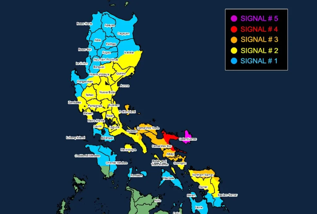
Signal No. 5 (Typhoon-force wind):
- Location: Catanduanes
- Wind Speed: 185 km/h or higher (Beaufort 12)
- Potential Impacts: Extreme threat to life and property.
Signal No. 4 (Typhoon-force winds):
- Locations:
- Northeastern Camarines Sur (Garchitorena, Caramoan, Presentacion, Siruma, Tinambac, Goa, Lagonoy, San Jose, Tigaon, Sagñay)
- Northeastern Albay (City of Tabaco, Tiwi, Malinao, Malilipot, Bacacay, Rapu-Rapu)
- Wind Speed: 118 to 184 km/h (Beaufort 12)
- Potential Impacts: Significant to severe threat to life and property.
Signal No. 3 (Storm-force winds):
- Locations:
- Polillo Islands, southeastern portion of Mainland Quezon (Calauag, Guinayangan, Tagkawayan, Buenavista), Camarines Norte, rest of Camarines Sur, rest of Albay, and northern portion of Sorsogon (Prieto Diaz, City of Sorsogon, Gubat, Barcelona, Castilla, Casiguran, Pilar, Donsol)
- Eastern and central portions of Northern Samar (Palapag, Laoang, Mapanas, Gamay, Lapinig, Catubig, Pambujan, Las Navas, Biri, Bobon, Catarman, Mondragon, San Roque, Silvino Lobos, Lope de Vega, San Jose)
- Northern portion of Eastern Samar (San Policarpo, Arteche, Oras, Jipapad)
- Wind Speed: 89 to 117 km/h (Beaufort 10 to 11)
- Potential Impacts: Moderate to significant threat to life and property.
Signal No. 2 (Gale-force winds):
- Locations:
- Southern portion of Isabela (Dinapigue, Cordon, Ramon, Alicia, City of Cauayan, Angadanan, City of Santiago, San Isidro, Echague, Jones, San Agustin, San Guillermo, San Mariano, Benito Soliven, Naguilian, Palanan)
- Quirino, Nueva Vizcaya, Eastern portion of Pangasinan (San Nicolas, Umingan, Natividad, San Quintin, Tayug, Santa Maria, Rosales, Balungao, San Manuel, Villasis, Malasiqui, Bautista, Mapandan, Binalonan, Alcala, Asingan, Santo Tomas, City of Urdaneta, Laoac, Manaoag, Bayambang, Santa Barbara)
- Aurora, Nueva Ecija, Bulacan, Tarlac, Pampanga, southern portion of Zambales (Botolan, Cabangan, San Marcelino, San Felipe, San Narciso, San Antonio, Castillejos, Subic, Olongapo City), Bataan, Metro Manila, Rizal, Rest of Quezon, Laguna, Cavite, Marinduque, Burias Island, and Ticao Island
- Central portion of Eastern Samar (Dolores, Maslog, Can-Avid, Taft, Sulat, San Julian, City of Borongan)
- Northern portion of Samar (Matuguinao, Calbayog City, Santa Margarita, San Jorge, San Jose de Buan, Tarangnan, Motiong, Gandara, Jiabong, City of Catbalogan, Paranas, Hinabangan, San Sebastian, Pagsanghan)
- Northern portion of Iloilo (Carles)
- Wind Speed: 62 to 88 km/h (Beaufort 8 to 9)
- Potential Impacts: Minor to moderate threat to life and property.
Signal No. 1 (Strong winds):
- Locations:
- Mainland Cagayan, rest of Isabela, Apayao, Kalinga, Abra, Mountain Province, Ifugao, Benguet, Ilocos Norte, Ilocos Sur, La Union, rest of Pangasinan, rest of Zambales, Batangas, northern portion of Occidental Mindoro (Sablayan, Santa Cruz, Mamburao, Abra de Ilog, Paluan) including Lubang Islands, northern portion of Oriental Mindoro (Puerto Galera, San Teodoro, Naujan, Baco, Victoria, Socorro, Pinamalayan, Bansud, Gloria, Pola, City of Calapan, Bongabong, Roxas, Mansalay)
- Romblon, rest of Masbate
- Eastern Samar, rest of Samar, Biliran, northern and central portions of Leyte (Tunga, Pastrana, San Miguel, Matag-Ob, Tolosa, Palo, Calubian, Leyte, Mayorga, Julita, Carigara, Babatngon, Dagami, Jaro, San Isidro, Santa Fe, Albuera, Villaba, La Paz, Palompon, Macarthur, Tabontabon, Tanauan, Merida, Ormoc City, Isabel, Dulag, Capoocan, Alangalang, Burauen, Tabango, Tacloban City, Kananga, Barugo, Abuyog, Javier, City of Baybay, Mahaplag)
- Northeastern portion of Southern Leyte (Silago)
- Northernmost portion of Cebu (Daanbantayan, Medellin) including Bantayan Islands
- Northernmost portion of Iloilo (Carles)
- Northern portion of Dinagat Islands (Loreto, Tubajon)
- Wind Speed: 39 to 61 km/h (Beaufort 6 to 7)
- Potential Impacts: Minimal to minor threat to life and property.
Coastal Inundation and Dangerous Seas:
The storm surge is expected to bring life-threatening conditions to coastal areas, with peak heights potentially exceeding 3 meters.
This affects the low-lying or exposed coastal areas of the Bicol Region, Samar, and other nearby provinces.
Mariners are strongly advised to avoid sea travel as conditions will be hazardous, with waves up to 14 meters high in some parts.
Heavy Rainfall and Flash Flood Risk:
Pepito’s heavy rainfall will also contribute to flooding, particularly in areas under higher wind signals.
The continuous rain, combined with strong winds, is expected to exacerbate the risk of landslides and flash floods, especially in mountainous and coastal areas.
Track and Landfall Forecast:
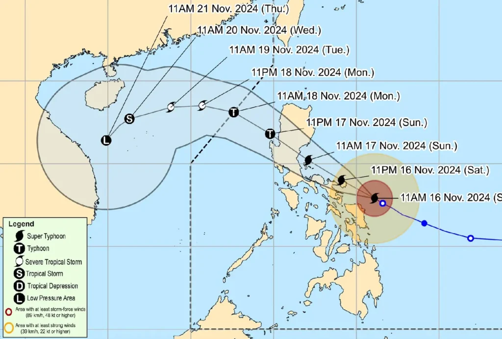
Pepito is expected to continue its west-northwestward track over the weekend, with landfall likely occurring in Catanduanes tonight or early Saturday morning.
While the typhoon is forecast to weaken slightly as it moves over mainland Luzon, it will remain a powerful typhoon through its passage.
The storm is predicted to exit the Philippine Area of Responsibility (PAR) by Monday.
Residents across the affected areas should remain on high alert, heed local authorities’ warnings, and prepare for dangerous conditions.
Updates will continue to be issued by PAGASA as the storm progresses.