Typhoon Nika (international name: TORAJI) continues to make its presence felt over the Cordillera Administrative Region, bringing intense winds and heavy rainfall to Northern Luzon.
The Philippine Atmospheric, Geophysical and Astronomical Services Administration (PAGASA) has issued its latest Tropical Cyclone Bulletin, providing critical updates on the storm’s path, intensity, and the associated threats to life and property.
Typhoon Nika’s Current Status
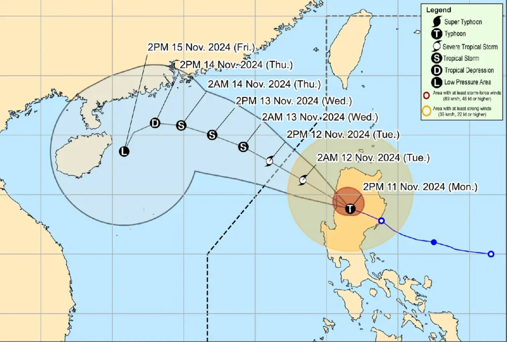
- Location (4:00 PM): The eye of Typhoon Nika was estimated near Besao, Mountain Province (17.1°N, 120.8°E).
- Intensity: Maximum sustained winds of 120 km/h near the center, with gusts reaching up to 200 km/h and a central pressure of 970 hPa.
- Movement: The typhoon is moving west-northwest at 25 km/h.
- Extent of Winds: Strong to typhoon-force winds are extending outward up to 340 km from the center.
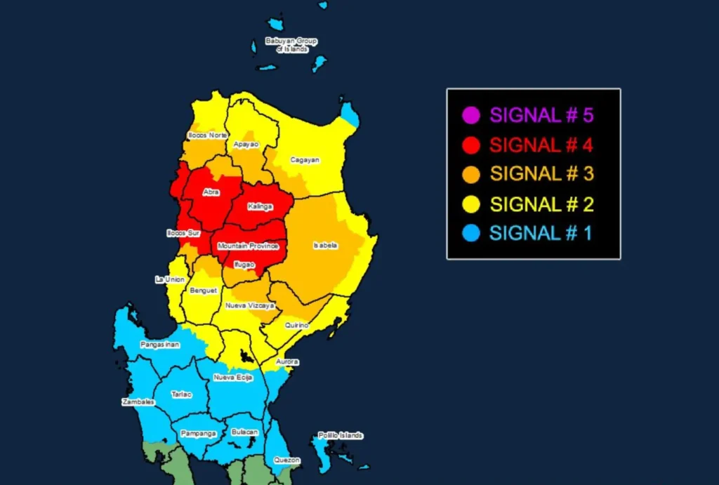
Tropical Cyclone Wind Signals (TCWS) in Effect

TCWS No. 4
- Areas Affected: Kalinga, Mountain Province, parts of Ifugao, central and southern Abra, and northern and central Ilocos Sur.
- Wind Threat: Typhoon-force winds (118 to 184 km/h).
- Lead Time: 12 hours.
- Impact: Severe threat to life and property, with extensive damage to structures and widespread power outages expected.
TCWS No. 3
- Areas Affected: Northern Quirino, northeastern Nueva Vizcaya, central Isabela, southwestern Cagayan, southern Apayao, the rest of Abra, and parts of Ilocos Norte, among others.
- Wind Threat: Storm-force winds (89 to 117 km/h).
- Lead Time: 18 hours.
- Impact: Moderate to significant damage to structures and potential risk to life and infrastructure.
TCWS No. 2
- Areas Affected: Northwestern and eastern Cagayan, the rest of Isabela, Nueva Vizcaya, Apayao, Benguet, and parts of Ilocos Norte.
- Wind Threat: Gale-force winds (62 to 88 km/h).
- Lead Time: 24 hours.
- Impact: Minor to moderate damage to infrastructure and vegetation.
TCWS No. 1
- Areas Affected: Babuyan Islands, remaining parts of Cagayan, Pangasinan, Nueva Ecija, Bulacan, and the northern parts of Zambales and Quezon.
- Wind Threat: Strong winds (39 to 61 km/h).
- Lead Time: 36 hours.
- Impact: Minimal to minor threat, with some risk to light structures and vegetation.
Rainfall and Coastal Warnings

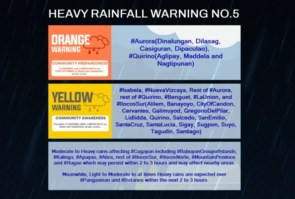
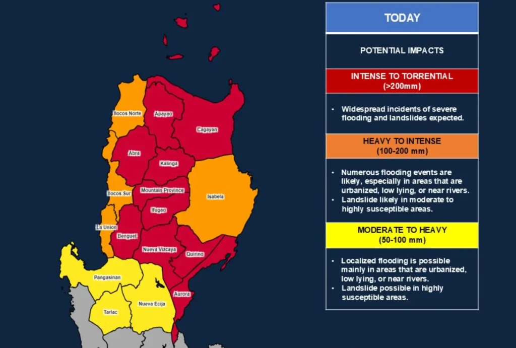
Heavy Rainfall Outlook: Torrential rains are expected over much of Northern and Central Luzon. Flooding and landslides are a major concern in vulnerable areas. Communities should heed advisories and follow evacuation orders as necessary.
Severe Winds: Typhoon Nika’s winds may enhance gustiness, especially in exposed coastal and mountainous regions. Significant damage is likely in areas under TCWS No. 4.
Storm Surge Warning: A moderate to high risk of storm surge exists over coastal areas of Ilocos Norte, Ilocos Sur, La Union, Pangasinan, Cagayan, and Isabela. Residents are urged to remain vigilant, particularly in low-lying and exposed coastal areas.
Sea Conditions and Marine Safety

- High to Very Rough Seas: Waves of up to 5.5 meters are anticipated along the eastern seaboard of mainland Cagayan, Isabela, and the seaboards of Ilocos Norte and Sur.
- Rough Seas: Expected along the northern seaboards of Batanes, northern Aurora, and other parts of Northern Luzon. Sea travel is risky for all vessels, and mariners are advised to remain in port until conditions improve.
Typhoon Nika’s Projected Track

Typhoon Nika is forecast to cross the mainland of Luzon today, exiting over the West Philippine Sea by tonight.
As it continues to move west-northwest, it is projected to weaken into a severe tropical storm due to land interaction.
Further weakening is expected as it heads towards southern China, potentially degenerating into a remnant low by the end of the week.
