


The tropical depression outside the Philippine Area of Responsibility (PAR) continues to intensify and is now moving west northwestward at a fast pace.
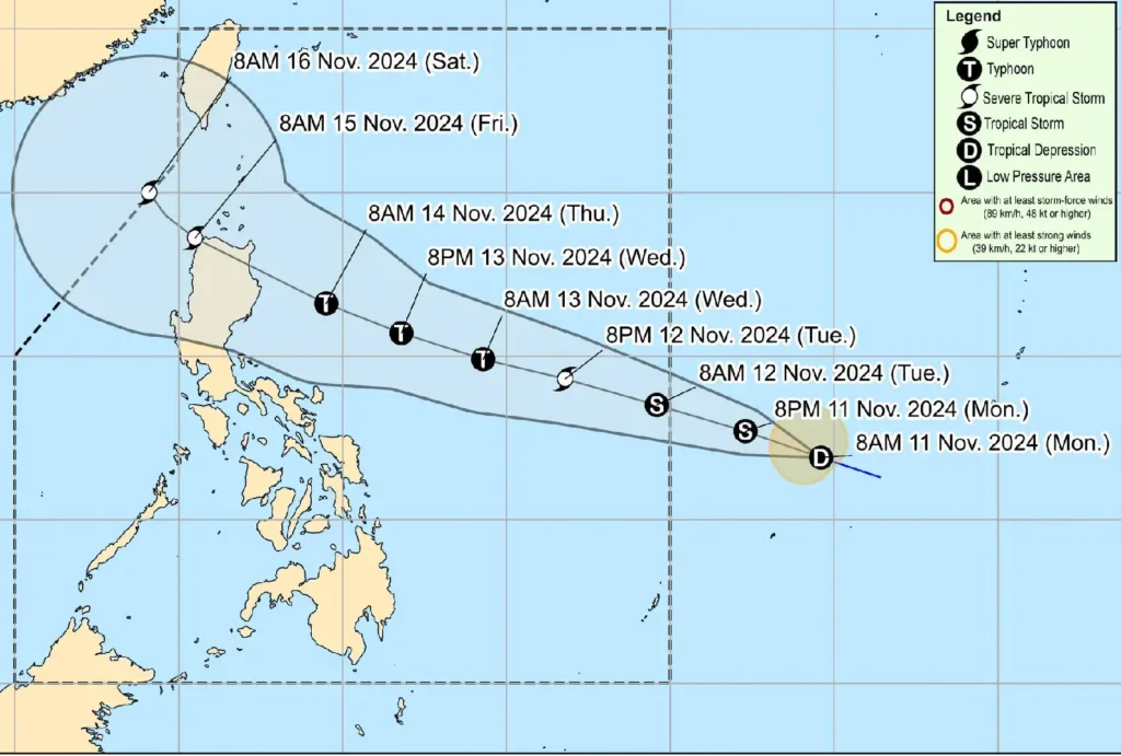
As of 10:00 AM today, the center of the depression was located 1,480 kilometers east of Eastern Visayas, at coordinates 12.1°N, 139.3°E.
Current Intensity:
- Maximum sustained winds: 55 km/h near the center
- Gustiness: Up to 70 km/h
- Central pressure: 1002 hPa
Movement:
- Present speed: West northwestward at 35 km/h
- Strong winds extend outward up to 190 km from the center
The tropical depression is expected to enter the Philippine Area of Responsibility (PAR) by tomorrow morning, 12 November 2024, and will be named “Ofel.”
It will continue its west northwestward track and may make landfall over Northern or Central Luzon by Thursday evening or early Friday morning.
Forecast: The depression is forecast to steadily intensify in the coming days and is expected to reach typhoon status by Wednesday. Landfall could occur at or near its peak intensity, with the potential for significant impacts across affected areas.
Hazards:
- Heavy Rainfall: Northern Luzon is at risk for heavy rains, which could lead to flooding and landslides.
- Strong Winds: Severe winds could affect parts of Northern Luzon, particularly in the landfall areas.
- Storm Surge: Coastal areas, especially in Northern and Central Luzon, may experience storm surge, potentially causing flooding and coastal erosion.
- Sea Conditions: Hazardous sea conditions (moderate to rough seas) are expected to develop along the northern and eastern coasts of the Bicol Region and Eastern Visayas by Wednesday, with similar conditions forecast for the northern and eastern seaboards of Northern and Central Luzon from late Wednesday through early Saturday.
Although landfall locations are still uncertain, residents in affected regions are urged to stay vigilant and follow the advisories of local authorities for updates.
As the storm track could shift, it is important to monitor the latest bulletins from PAGASA.